Page 1 of 2
Emigrant: Chain Lakes to Grouse Lakes
Posted: Sun Aug 02, 2020 10:53 pm
by Cruzberg
Hi All,
AllTrails shows a trail linking Chain Lakes (accessed from Box Springs Trailhead) to Grouse Lake (see attachment). The official Emigrant Wilderness map does not show this, and it appears to be unmaintained. Does anyone have any info on this trail? Is it usable? Super steep?
Also anyone have any beta on the mosquitoes out there right now?
Thanks!
Re: Emigrant: Chain Lakes to Grouse Lakes
Posted: Mon Aug 03, 2020 6:21 am
by balzaccom
I've seen a relatively large cairn at this junction, and assumed it led to Chain Lakes. But I've never followed it. The topogrphy in this area isn't too hard to follow. We have a trip report on Chain Lakes from the other side on our website.
Re: Emigrant: Chain Lakes to Grouse Lakes
Posted: Mon Aug 03, 2020 8:15 am
by kpeter
Good question. I have not been to Chain Lakes and I don't recall seeing a marked intersection at the west (I originally mistakenly said "east") end of Grouse Lake, the two times I have been by there--but I would certainly accept Balzacom's memory of a cairn. I wonder if the trail up to Chain lakes is similar to the trail that goes up to Rosaco Lake from Louse Canyon? That trail--and in fact all the trails to Big Lake, Pingree, and over to Leighton's Camp near Yellowhammer--are now unmarked and unmaintained and therefore quite intermittent. I found I could follow all the routes and came across trail remnants just often enough to keep my bearings. I think many of those trails were Leighton's creations and have been allowed to revert--making for something that is almost cross country but not quite. But all this is just an educated guess when it comes to a Grouse-Chain Lakes trail.
Re: Emigrant: Chain Lakes to Grouse Lakes
Posted: Mon Aug 03, 2020 5:13 pm
by phoenix2000
In 2014 & 2015 I started at the Crabtree trailhead, made it to Grouse Lake then climbed up to Chain Lakes. Neither time did I see any evidence of a trail. The ascent is super steep at first and is easy right before you get to Chain Lakes. Looking at the map now I think I just climbed straight up by the west end of the lake instead of heading southeast to begin with like the map shows the trail going. In the beginning, I followed a section of the mountain that has a runoff of water in earlier months but in August it was mainly dry with a few pools here and there.
I 2014 I decided to stay at Chain Lakes before even going on the trip. This was due to the trip reports where people stated that cows graze in the valley that Grouse Lake is in and some have even seen the cows standing in the lake. Both years I saw and heard cows in the creek flowing out of Grouse Lake but not at the lake itself.
Re: Emigrant: Chain Lakes to Grouse Lakes
Posted: Mon Aug 03, 2020 5:40 pm
by balzaccom
To clarify--the cairn I saw was at the West end of Grouse, not the East end.
And the official designation of these is "routes" not trails, because while they may or may not be marked, they are not maintained...at least by the USFS.
Re: Emigrant: Chain Lakes to Grouse Lakes
Posted: Wed Aug 05, 2020 2:15 pm
by Enigmagic
Alltrails probably is using
OpenStreetMap, which mentions a USGS 24K map... while it's not there anymore it shows up on the 1990 quad:
Re: Emigrant: Chain Lakes to Grouse Lakes
Posted: Wed Aug 05, 2020 3:38 pm
by phoenix2000
I looked thru my pictures and found one that gives you some idea of how steep a climb it would be. The picture is taken from the northwest corner of
Grouse Lake and looking towards the southeast corner. The section where the trail would be unfortunately is off of the picture
to the right, but you still can get an idea of what the climb would be like. I remember the first 50 feet or so being easy then it gets steep enough where I was sometimes having
to use both my hands and feet
to climb up or I was having
to raise my right foot above my left knee, place it on a rock or ledge, then use my trekking poles
to help me lift myself up.
 Viewed 221 times")
- Grouse Lake, taken from northwest corner looking towards southeast corner
I noticed that the title says
Chain Lakes to Grouse Lake so your going down and not up. In 2014 I chose
to go cross country from
Chain to Hyatt but didn't like it. So in 2015 I instead went from
Chain back down
to the trail that runs by
Grouse Lake but I went east from
Chain Lakes then dropped down where the slope wasn't as bad. I ended up coming out on the trail just before it climbs. About 30 yards from the gate and fence put there
to keep the cows from going any further east. I've marked the route I took in orange on the map below. It was easy going except for when I hit the bottom of the slope and had
to deal with 100 yards of really dense bush with a dried creek bed running thru it.
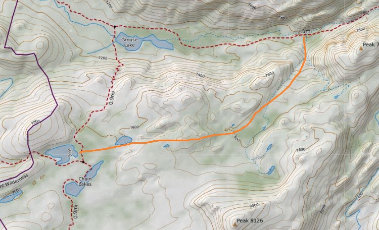
- Map.JPG (131.94 KiB) Viewed 216 times
Re: Emigrant: Chain Lakes to Grouse Lakes
Posted: Mon Aug 10, 2020 10:09 pm
by Cruzberg
Hi All,
Just as a follow-up, we did this over the weekend. The route shown on AllTrails was doable but not ideal with dogs, as there was some serious down-climbing and we ended up having
to pass the canines down
to each other. On the way out, we took a mellower route that ascended a "ramp", and it was much more comfortable and probably took less time (see attached map).
We went
to Pingree from Boxsprings TH, and saw maybe 5 mosquitoes the whole time! Get out there!

- Capture.PNG (239.38 KiB) Viewed 185 times
Re: Emigrant: Chain Lakes to Grouse Lakes
Posted: Tue Aug 11, 2020 8:24 am
by looks easy from here
Thanks for the follow up and mosquito report. I'm headed that direction in just a few days. If you don't mind being pestered for a bit more info, how many cars were at the Box Spring TH, and how many people did you see camped around the first Chain Lake? I know those aren't static numbers, just hoping to get a general idea of the area's popularity right now (I've only been in October).
Re: Emigrant: Chain Lakes to Grouse Lakes
Posted: Tue Aug 11, 2020 12:38 pm
by murphtron
I know a family of 4 just hiked up from Grouse to Chain. A bit steep in places but the 12yo made it fine. Grouse Lake, BTW, is a miserable place to camp. Camped there our last night just so the hike out via Crabtree would be shorter. The entire hill to the south of Grouse L is dotted with poo and toilet paper. The FS should really have porta potties by that 'lake' as it's heavily used (why? I have no idea).
And I'll never use Crabtree to Pine Valley route again. Would rather put in a bit more effort, but fewer miles, and use Box Springs or Bourland trailheads to hit the lakes in the Pingree region. Heading back in on Thursday to Big Lake.