TR: Sphinx Crest Loop 7/16 - 7/20 2012
Posted: Wed Sep 05, 2012 4:02 pm
My planned route was a circumnavigation of Sphinx Crest: Road's End to Upper Sphinx Creek to Sphinx Lakes, over Sphinx Col to Big Brewer Lake, then over to the Avalanche Pass trail and out again. The design of the trip was driven by a single location...where I ended up spending about an hour. But more about that later.
Sunday morning I left at the cracko and got up to Kings Canyon a little after 11:30. At Moraine Campground I found my friends Lou and Tony and Tony's friend Davie, from Scotland; they were all leaving Tuesday for a 9-day trip over the Monarch Divide, and meanwhile hanging in the valley and fishing the South Fork Kings. I got my permit and spent the rest of the day at the campsite, drinking beer and swapping stories.
Next morning I was up a little after 5:00, and was on the trail at Road's End a little after 6:30. At the trailhead was a sign saying fire had closed the Woods Creek stretch of trail (from Paradise to the bridge); bummer for all those people getting Rae Lakes Loop permits yesterday.
Five minutes down the trail I reached into my shirt pocket and...no map. Back in the car. So I dropped my pack at the permit station and went back to the car for my maps. At about 6:50 I was on the trail again, this time for good.
I made good time on the first leg, getting to Sphinx Creek junction in just under 2 hours. Early start is key here: I was in nice cool shade until just after the Bubbs Creek switchbacks. Encouraged by the good start, I started up the Avalanche Pass trail toward Sphinx Creek.
Can I just say how much I hate this trail? (A lot, is how much, in case you were wondering.) You take a trail like the Copper Creek Trail (which is often unfairly maligned): you can plod up, and cruise down. Copper Creek Trail, you just keep putting one foot in front of the other and sooner or later you'll get somewhere. The trail up Sphinx Creek, though, those rocky switchbacks, it's impossible to get into any kind of a decent rhythm going up or [SPOILER] down. I found that stretch really enervating, and my pace was maybe half what it had been on the first leg.
Then you get above the cut-into-the-rock switchbacks and you're on more or less normal trail, and you get into the switchbacks climbing away from Sphinx Creek. Which, you do a few switchbacks, right, and then you start to hear the side creek approaching--the side creek that you cross once you've reached the top of the switchbacks--and you're almost to the creek and then suddenly the trail doubles back. Another switchback. And then another and another and another and another, and they're really long switchbacks, and every single time the trail gets almost to the creek so you think maybe this time and then at the last moment your hopes are dashed. Around the upmteenth time this happened I just shouted "are you f***ing SERIOUS?" at the trail.
The trail did not respond.
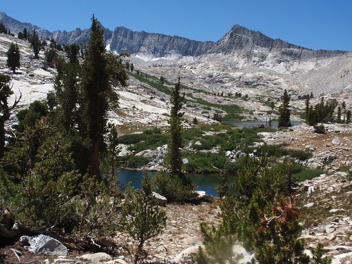
I dragged myself into Upper Sphinx Creek a little after noon. There's one campsite right by the creek, a little upstream from the crossing, and another back in the woods west of the creek and north of the trail. I took this one. It's not a particularly attractive spot--lots of down trees everywhere--but after 3500' of climb I certainly didn't have the juice to go any further that day.
(If someone forced me to at gunpoint, I might admit that I could have been in better shape, and that I'm not as young as I used to be. But nobody's holding a gun to my head right now, so I'm not admitting that.)
So I spent the afternoon reading (War and Peace, which I last read more than a quarter century ago), with a couple of strolls out to the meadow to try to figure out the next day's route.
Around 8:00 pm, as I was taking another stroll, I ran into a hiker just arriving from below. We chatted briefly; he described a route that sounded like the Circle of Solitude, but with an eastern entry. It wasn't until after I had gone back to my site that I remembered someone here was doing a route like that; turns out the hiker was Schmalz.
Next morning I slept in until nearly 6:00 am, and didn't get on the trail until 7:10.
Above the trail, Sphinx Creek goes through a series of stepped hanging valleys. The first riser presents a particulary ugly prospect: the west side is one big talus slope, the east side is steep and rocky, and in between near the stream it's all rocky and willow-choked. I followed an intermittent trail remnant along the western edge of the meadow; at the head of the meadow, it appeared to point straight into that willow hell. Didn't look appealing, but it didn't look any less appealing than the alternatives, so I tried it.
Turns out there's a pretty clear way up a little west of the stream that isn't apparent when you're looking from a distance. (General tip for Sphinx Creek basin: if you find a trail remnant, follow it; it never steered me wrong.) Once up this it's slabs and open forest (with smokey views back toward the valley) for a little ways. I got a little above the second valley, thinking maybe I could keep traversing upslope, but that's more trouble than it's worth and I wound up dropping back to near creek level.

The forest & undergrowth get thicker as you get further into the second valley, and there's a wet jungle-ish stretch just before the next climb. Best bet is to bypass as much of this as possible by staying on the right (west), then traverse up the slopes to the right to get to the next level. Then it's fairly easy slopes up to the first lake.
The swampy area on the map looks like a nice green meadow but it is, in fact, swampy, so as tempting as a shortcut looks it's better to go around it on the west. That sets you up for a nice gentle climb up the slabs, meeting up with the creek again and crossing it somewhere around the 10000' contour.
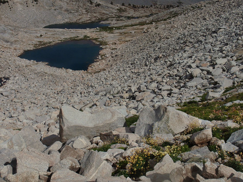
I got to the second lake and then ended up backtracking slightly; the shortest way is to veer northeast just before you reach the lake. That takes you into a nice valley that leads east and up above the lake (and above the cliffs on the east side). You get to a meadowy flat around 10160 or so; here you want to veer right (south) to the low-angle slabs at the far side of the meadow. These slabs take you all the way to Lake 10514.
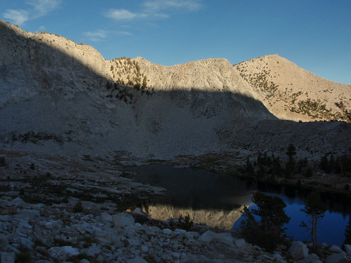
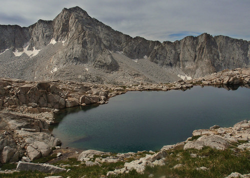
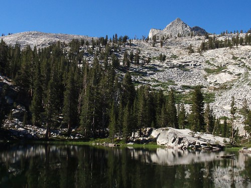
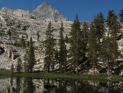
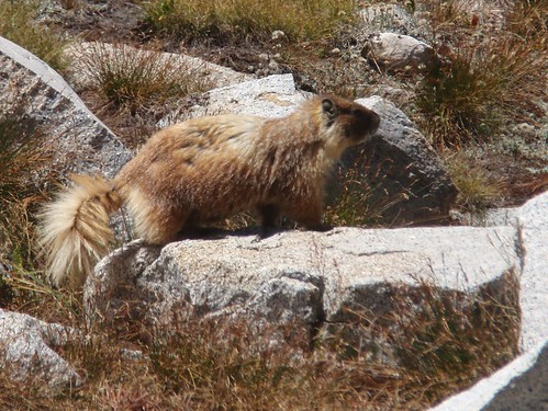
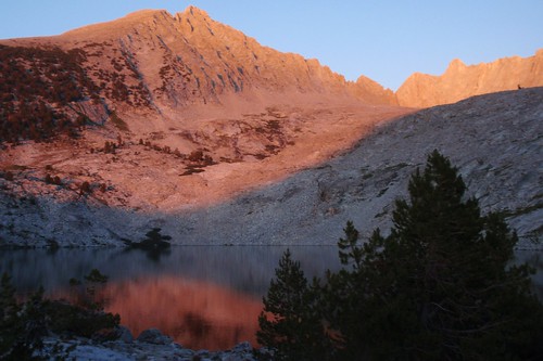
I set up camp in a little whitebark-and-foxtail grove a north of the western end of the lake, looking out on the lower Sphinx Creek basin and over to the Monarch Divide. (There are some really magnificent foxtail pines at Sphinx Lakes.) Couple of marmots spent a while checking me out, coming in closer than marmots usually do. Marmots are at their most hilarious when they're trying to be all stealthy and invisible. One was watching me from a crack in a boulder about 5 feet away and I just stared straight back at it. You aren't fooling me, adorable rodent!
But just in case, I hung my pack from a whitebark branch. Chewed packstraps are generally considered sub-optimal.
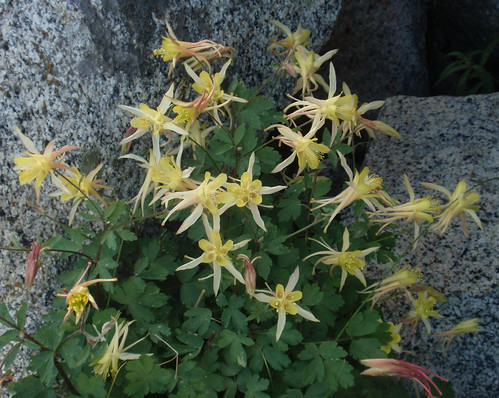
Later in the afternoon I took a walk over to Lake 10546. Right by the outlet there was a beautiful patch of Sierra Columbine.
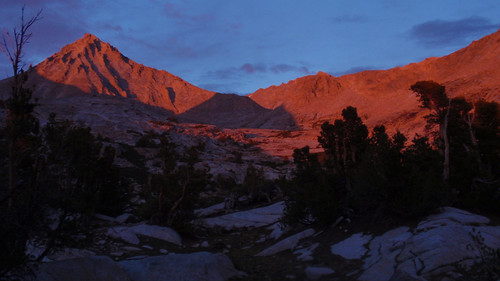
Later still, after dinner, I watched the peaks turn orange-pink in the alpenglow.
Sunday morning I left at the cracko and got up to Kings Canyon a little after 11:30. At Moraine Campground I found my friends Lou and Tony and Tony's friend Davie, from Scotland; they were all leaving Tuesday for a 9-day trip over the Monarch Divide, and meanwhile hanging in the valley and fishing the South Fork Kings. I got my permit and spent the rest of the day at the campsite, drinking beer and swapping stories.
Next morning I was up a little after 5:00, and was on the trail at Road's End a little after 6:30. At the trailhead was a sign saying fire had closed the Woods Creek stretch of trail (from Paradise to the bridge); bummer for all those people getting Rae Lakes Loop permits yesterday.
Five minutes down the trail I reached into my shirt pocket and...no map. Back in the car. So I dropped my pack at the permit station and went back to the car for my maps. At about 6:50 I was on the trail again, this time for good.
I made good time on the first leg, getting to Sphinx Creek junction in just under 2 hours. Early start is key here: I was in nice cool shade until just after the Bubbs Creek switchbacks. Encouraged by the good start, I started up the Avalanche Pass trail toward Sphinx Creek.
Can I just say how much I hate this trail? (A lot, is how much, in case you were wondering.) You take a trail like the Copper Creek Trail (which is often unfairly maligned): you can plod up, and cruise down. Copper Creek Trail, you just keep putting one foot in front of the other and sooner or later you'll get somewhere. The trail up Sphinx Creek, though, those rocky switchbacks, it's impossible to get into any kind of a decent rhythm going up or [SPOILER] down. I found that stretch really enervating, and my pace was maybe half what it had been on the first leg.
Then you get above the cut-into-the-rock switchbacks and you're on more or less normal trail, and you get into the switchbacks climbing away from Sphinx Creek. Which, you do a few switchbacks, right, and then you start to hear the side creek approaching--the side creek that you cross once you've reached the top of the switchbacks--and you're almost to the creek and then suddenly the trail doubles back. Another switchback. And then another and another and another and another, and they're really long switchbacks, and every single time the trail gets almost to the creek so you think maybe this time and then at the last moment your hopes are dashed. Around the upmteenth time this happened I just shouted "are you f***ing SERIOUS?" at the trail.
The trail did not respond.
I dragged myself into Upper Sphinx Creek a little after noon. There's one campsite right by the creek, a little upstream from the crossing, and another back in the woods west of the creek and north of the trail. I took this one. It's not a particularly attractive spot--lots of down trees everywhere--but after 3500' of climb I certainly didn't have the juice to go any further that day.
(If someone forced me to at gunpoint, I might admit that I could have been in better shape, and that I'm not as young as I used to be. But nobody's holding a gun to my head right now, so I'm not admitting that.)
So I spent the afternoon reading (War and Peace, which I last read more than a quarter century ago), with a couple of strolls out to the meadow to try to figure out the next day's route.
Around 8:00 pm, as I was taking another stroll, I ran into a hiker just arriving from below. We chatted briefly; he described a route that sounded like the Circle of Solitude, but with an eastern entry. It wasn't until after I had gone back to my site that I remembered someone here was doing a route like that; turns out the hiker was Schmalz.
Next morning I slept in until nearly 6:00 am, and didn't get on the trail until 7:10.
Above the trail, Sphinx Creek goes through a series of stepped hanging valleys. The first riser presents a particulary ugly prospect: the west side is one big talus slope, the east side is steep and rocky, and in between near the stream it's all rocky and willow-choked. I followed an intermittent trail remnant along the western edge of the meadow; at the head of the meadow, it appeared to point straight into that willow hell. Didn't look appealing, but it didn't look any less appealing than the alternatives, so I tried it.
Turns out there's a pretty clear way up a little west of the stream that isn't apparent when you're looking from a distance. (General tip for Sphinx Creek basin: if you find a trail remnant, follow it; it never steered me wrong.) Once up this it's slabs and open forest (with smokey views back toward the valley) for a little ways. I got a little above the second valley, thinking maybe I could keep traversing upslope, but that's more trouble than it's worth and I wound up dropping back to near creek level.
The forest & undergrowth get thicker as you get further into the second valley, and there's a wet jungle-ish stretch just before the next climb. Best bet is to bypass as much of this as possible by staying on the right (west), then traverse up the slopes to the right to get to the next level. Then it's fairly easy slopes up to the first lake.
The swampy area on the map looks like a nice green meadow but it is, in fact, swampy, so as tempting as a shortcut looks it's better to go around it on the west. That sets you up for a nice gentle climb up the slabs, meeting up with the creek again and crossing it somewhere around the 10000' contour.
I got to the second lake and then ended up backtracking slightly; the shortest way is to veer northeast just before you reach the lake. That takes you into a nice valley that leads east and up above the lake (and above the cliffs on the east side). You get to a meadowy flat around 10160 or so; here you want to veer right (south) to the low-angle slabs at the far side of the meadow. These slabs take you all the way to Lake 10514.
I set up camp in a little whitebark-and-foxtail grove a north of the western end of the lake, looking out on the lower Sphinx Creek basin and over to the Monarch Divide. (There are some really magnificent foxtail pines at Sphinx Lakes.) Couple of marmots spent a while checking me out, coming in closer than marmots usually do. Marmots are at their most hilarious when they're trying to be all stealthy and invisible. One was watching me from a crack in a boulder about 5 feet away and I just stared straight back at it. You aren't fooling me, adorable rodent!
But just in case, I hung my pack from a whitebark branch. Chewed packstraps are generally considered sub-optimal.
Later in the afternoon I took a walk over to Lake 10546. Right by the outlet there was a beautiful patch of Sierra Columbine.
Later still, after dinner, I watched the peaks turn orange-pink in the alpenglow.