Page 8 of 23
Re: 2011 BACKCOUNTRY CONDITIONS UPDATES: Wallace Creek/Forrester
Posted: Thu Jul 07, 2011 1:51 pm
by cgundersen
Quentin,
My wife and I gave a ride to a guy who hiked the JMT from W portal and exited via Bishop Pass. He said he had to go about a mile upstream to find a place to cross Wallace, and even so it was mid-chest. But, that would have been around June 30, so it could be better, it could be worse. His worst day was going over Forrester. Massive sun, few tracks and snow forever. But, he made it over after camping by Tyndall Creek the night before. From the tracks we saw on Muir Pass on June 25th, quite a few folks had made it over the high passes on the PCT/JMT, some with snowshoes, most without. There are some motivated souls out there!
cg
Re: 2011 BACKCOUNTRY CONDITIONS UPDATES
Posted: Thu Jul 07, 2011 2:19 pm
by KathyW
quentinc wrote:Kathy, thanks for that report. How was Wallace Creek (if you got that far)? I have some friends who were planning on the JMT starting on July 10, and they are now looking for alternatives since they aren't experienced with rough conditions. I was going to suggest they head down to Junction Meadow from the JMT and then loop south along the Kern.
I did not go as far as Wallace, but I met a guy coming north that had crossed it. He said Wright was worse than Wallace, and you can cross Wright as long as you're willing to hike upstream until you find a good place to cross.
Re: Leavitt Meadows/Beartrap Lake
Posted: Thu Jul 07, 2011 3:00 pm
by TehipiteTom
no2haven wrote:Yeah, most of those creeks are easy boot crossings too...I just don't like getting wet, and will take the easy log over shallow water every time.
I'm the opposite. I don't mind a big fat (dry, level) log or a set of easy steps on (dry) rocks, but otherwise I prefer the certainty of wet feet to the possibility of injury if I lose footing trying to avoid getting my feet wet.
Re: 2011 BACKCOUNTRY CONDITIONS UPDATES
Posted: Thu Jul 07, 2011 3:39 pm
by quentinc
Thanks CG and Kathy. I guess my friends will just have to hike up to Wallace and make their own call. They're very cautious sorts, so I'm not worried about sending them that far. But Forester Pass will definitely be the Maginot Line!
Florence Lake, Muir Trail Ranch, Kaiser Pass
Posted: Sun Jul 10, 2011 6:59 am
by AlmostThere
Trails are opening right and left. The trail between MTR and Florence is open, but in places under water, and in other places (meadows) muddy as heck.
The roads into Edison and Florence are free and clear - patchy snow continues to exist at about 9,000 feet along Kaiser Pass. Nearly everything below 9,000 in that area is melted out.
Piute Pass is still icy and snowy.
Re: 2011 BACKCOUNTRY CONDITIONS UPDATES
Posted: Sun Jul 10, 2011 6:23 pm
by Packtofish
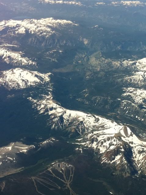
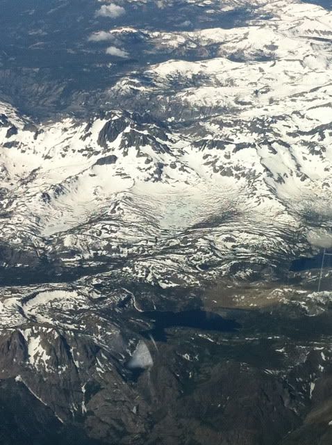
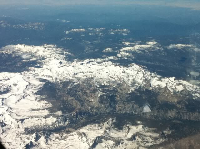
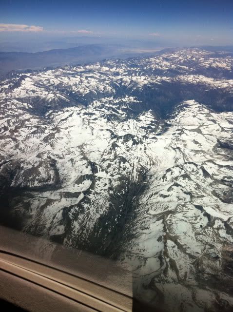
Not so much a trip report, but I flew across the Sierra today and passed over Evolution Valley and had a good look at the area. From what I saw, Wanda lake and the Muir Pass area was nearly solid snow cover. Saffire was maybe 20% clear. The Darwin Lakes looked like they had nearly solid cover. I also passed over east to west, just north of Mammoth and saw that Thousand Island and Garnet were still snow covered, but there was signs of water showing from the air.
Didn't have my good camera, but I snapped a few cruddy iPhone pics.
Reds Meadow
Thousand Island Lake
Southern Yosemite and the Clarke Range
Goddard Canyon
Muir Pass and Wanda under snow
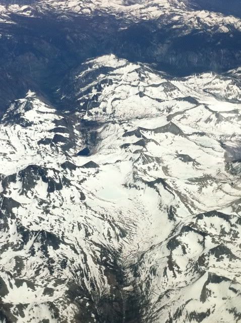
Apologize for the crummy pics....
Re: 2011 BACKCOUNTRY CONDITIONS UPDATES
Posted: Sun Jul 10, 2011 7:48 pm
by gary c.
Pictures look great to me. Things are looking much better than a few weeks ago. Thanks for posting them.
Cottonwood Pass, Miter Basin, Soldier Lakes 7/2-7/9
Posted: Tue Jul 12, 2011 7:58 am
by papercup
Spent a week (7/2 - 7/9) in the southern sierra via Cottonwood Pass. Conditions were excellent. There's still some snow floating around, but most trails are largely snow-free, and those that retain cover are easily navigable. Climbed Langley and Cirque, explored the Siberian Outpost, Whitney Meadows, Miter Basin, Upper and Lower Soldier Lakes. All are doable. A few spots are made more complicated by the snow. Rock Creek was not a problem. A few of the higher lakes are still partially frozen. Some of the lower lakes and streams were full of trout.
Also climbed Army Pass and New Army Pass from the West. It's easy enough to get to the top, but both passes remain snow-covered from the East and should not be climbed without proper equipment. Poles and boots won't cut it.
If anybody would like more information on any of these spots, I'd be happy to provide what I can.
It's still fairly quiet out there. Except for the PCT, we rarely saw more than one or two groups a day. Some days passed in complete isolation. Bumped into a solo hiker on Langley, and spied one photographer from the distance while viewing Miter Basin from the Major General, but otherwise saw nobody while off trail. I don't know if this is just a quiet area or what, but the isolation was nice. Even Chicken Spring Lake, which I expected to be quite busy, had only one other tent during the night we spent there.
Re: 2011 BACKCOUNTRY CONDITIONS UPDATES
Posted: Tue Jul 12, 2011 8:12 am
by mschnaidt
Hey Papercup,
Thanks for posting. Do you have any photos of Army Pass? I'm hoping to head through the pass without crampons and ice axe two weeks from today. Any feedback would be appreciated.
M
Re: 2011 BACKCOUNTRY CONDITIONS UPDATES
Posted: Tue Jul 12, 2011 8:21 am
by hikerchick395
After hiking up to Piute Pass last Friday, I was curious about Kearsarge Pass, so hiked up there yesterday. (The SEKI NPS site claimed that the Kearsarge Basin was still snowbound on their July 8 report.) Not many cars at the trailhead. Snow was icy early, but softened up nicely. It ended up that there was more snow on the eastside...the trail to the west was clear and the lakes were ice free (except a tiny bit on the western most Kearsarge Lake.)