TR: Dinkey Lakes Wilderness, 7/5-7/6
Posted: Fri Jul 12, 2019 8:28 pm
For a quick overnighter to a popular low-elevation area of the Sierra, the planning of this trip involved more than a bit of intrigue. I wasn't sure that this trip was going to work until two days before. The Sierra National Forest Facebook page said that the Dinkey Lakes were inaccessible due to snow. The main Dinkey Lakes trailhead couldn't be driven to, though I was told one could drive to "5-6 miles from the trailhead." The road to Courtright was open, but the last few miles to the Cliff Lake trailhead were said to be closed. I was tracking snow levels using satellite map layers fanatically, refreshing the Conditions section of this forum as often as possible, and pestering the poor folks at the High Sierra Ranger District station as often as I thought they had new information.
The latest high res satellite image on 7/1 showed things looking up: Bullfrog Lake was ice-free, and the road from the Courtright dam to the Cliff Lake trailhead looked snow-free too. I was still worried about the Nelson Creek crossing, especially as one person in our group wasn't a very experienced backpacker. But then on July 3 Mav re-posted a conditions update from someone who had just been in the area and who confirmed that there was a crossing 100 yards upstream of Nelson Creek that was only knee-deep. We were good to go.
The Clovis FS headquarters was closed on July 4 for the holiday, so I made the drive up to Prather to pick up our walk-in permits for July 5 when the office opened at 8:00am. We got there a few minutes late, and there were already 4 parties in front of me. I tried my hardest to eavesdrop on their conversations to ascertain whether or not I'd be able to snag my permits -- I needed 5 of the 8 available. 20 minutes later I got to the front, picked up the permit, and headed back to enjoy the rest of my 4th.
On Friday morning, we fueled up in Sanger and drove up to Courtright. I haven't driven past the Dinkey Road turnoff in over 15 years, so it was a fun drive peering around every corner trying to reacquaint myself with my surroundings. We got to the Cliff Lake trailhead after 2.5 hours, surprised by the number of cars in the parking lot, and geared up. Mosquitoes were about a 2-3.
The hike down to Nelson Creek was straightforward and thankfully downhill. This was our first backpack of the season, so in good hiking shape we were not. Upon arriving at the creek, we turned upstream and, just as expected, a much more mellow section appeared in about 100 yards. We forded and none of our oxen died. The water was cold as snow. The first two seconds were pleasant, the next three were tolerable, and then the following 5 were highly uncomfortable. Had the crossing taken longer than 10 seconds, who knows how I'd describe it. I'd been reading all of the cautionary threads on HST about stream crossings and the much more significant danger posed by water than by snow, so the risk was very present in my mind.
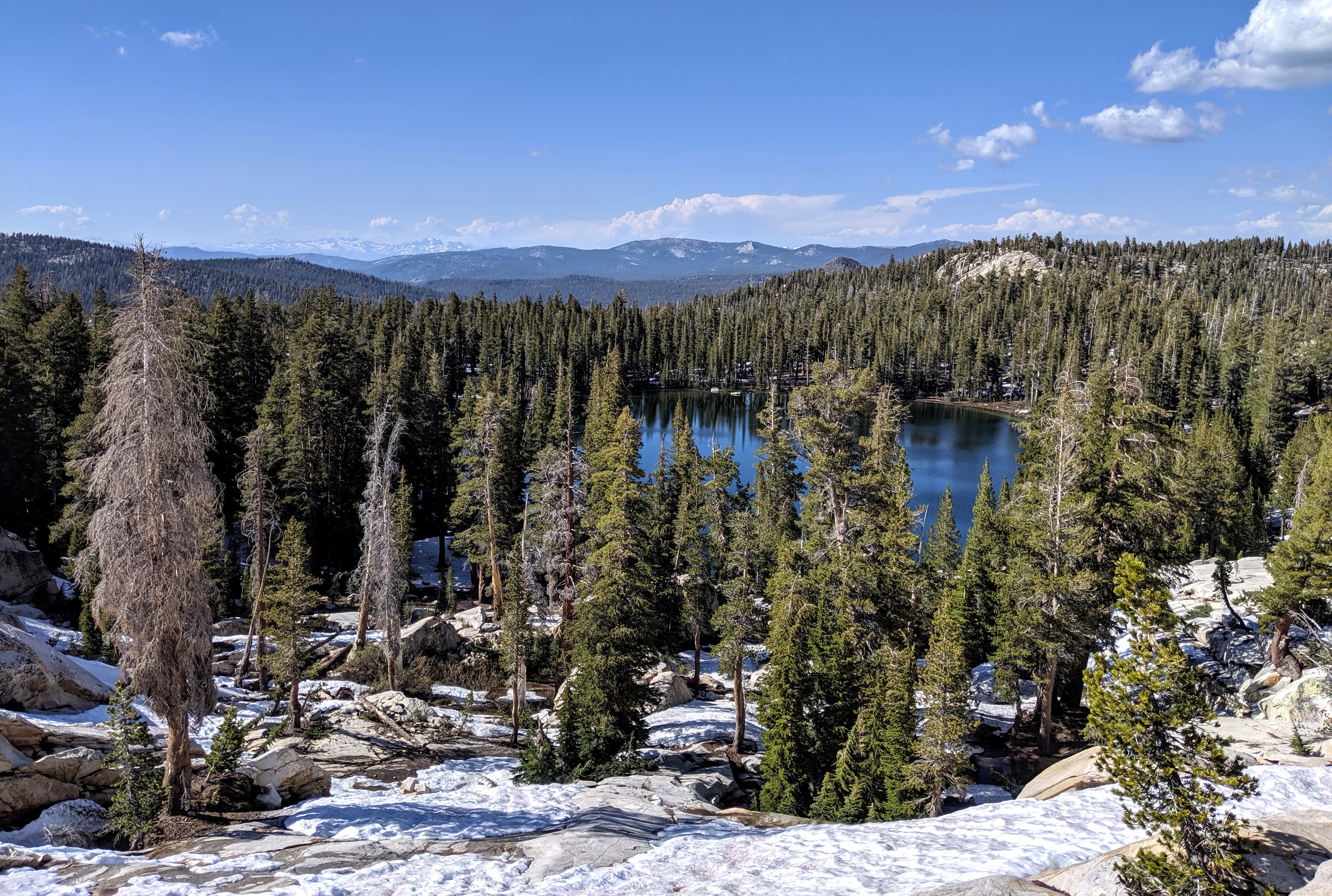
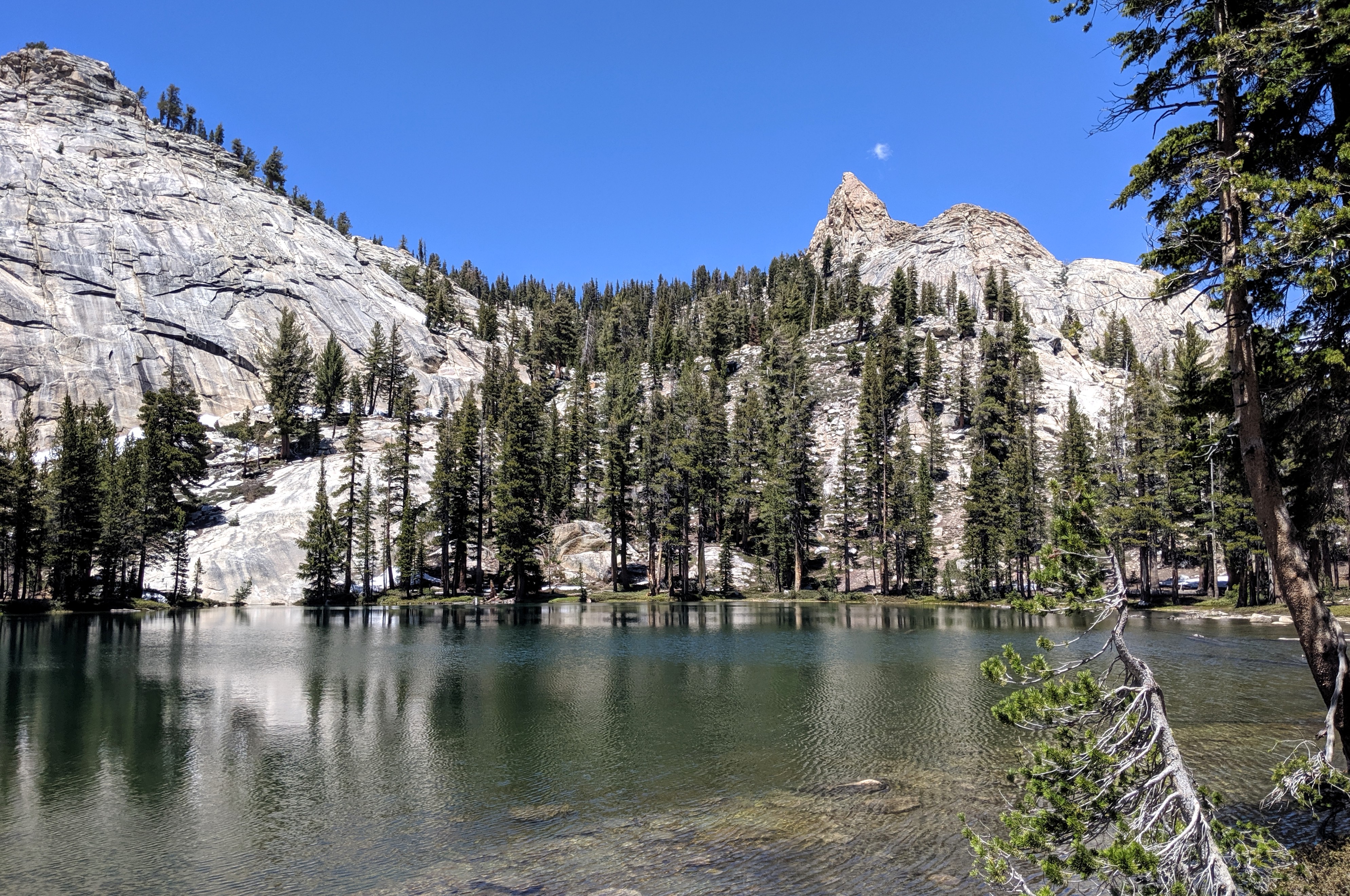
The rest of the hike up to Cliff Lake was snow-free and iffy stream crossing-free. I'd never hiked this trail before, so I was surprised by how gradual it is. There were a handful of groups coming back down, and we passed a few groups going up. Once we hit the Cliff Lake turnoff, we veered off-trail a bit and hooked up with the unmaintained trail to Bullfrog. We had the lake to ourselves (saw several folks going to/coming from Cliff) so we took our time and found a good well-used campsite on the northeast corner and set up camp there.
I stopped to fish a bit and the rest of my party decided to spend the afternoon relaxing around the lake, but I had designs on further exploration so I headed out to check out the rest of the Dinkey Lakes. Up to Rock Pass was snow-free, but on the north side of the pass the trail disappeared in snow. I continued down to Rock, where the lake was about 1/4 frozen. My goal was to visit Island so I was tempted to head directly there (SW of Rock), but the slope was covered in a solid snow field with a steep gradient so I thought better of it and headed the long way around Rock. Once I was due W of Rock I headed straight toward Island, crossing several more snow fields until I topped out on the small cliffs above Island's eastern shore.
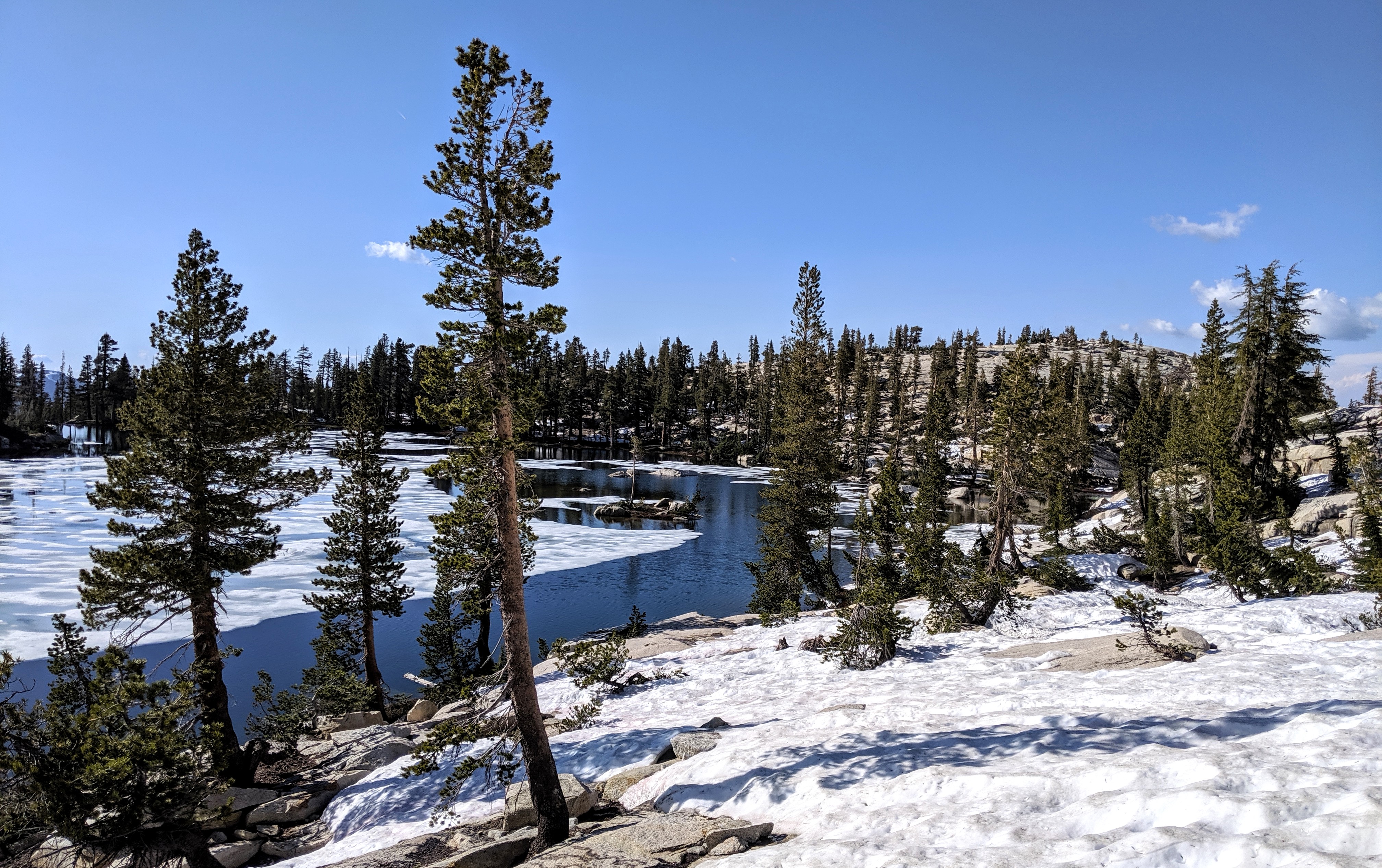
Island was still about 75% covered in ice, with most open water on the southwest corner and western fringe. I circumnavigated the lake clockwise, hopping across the one narrow part of the swollen inlet creek, and trying a bit of fishing. No luck, though a few people camped at the lake told me they saw a fish. I headed back around 6:30pm and got back to Bullfrog an hour later, in time for a hearty dinner and drinks at camp. Mosquitoes were present but not bad at all -- I imagine they'll be much worse very soon.
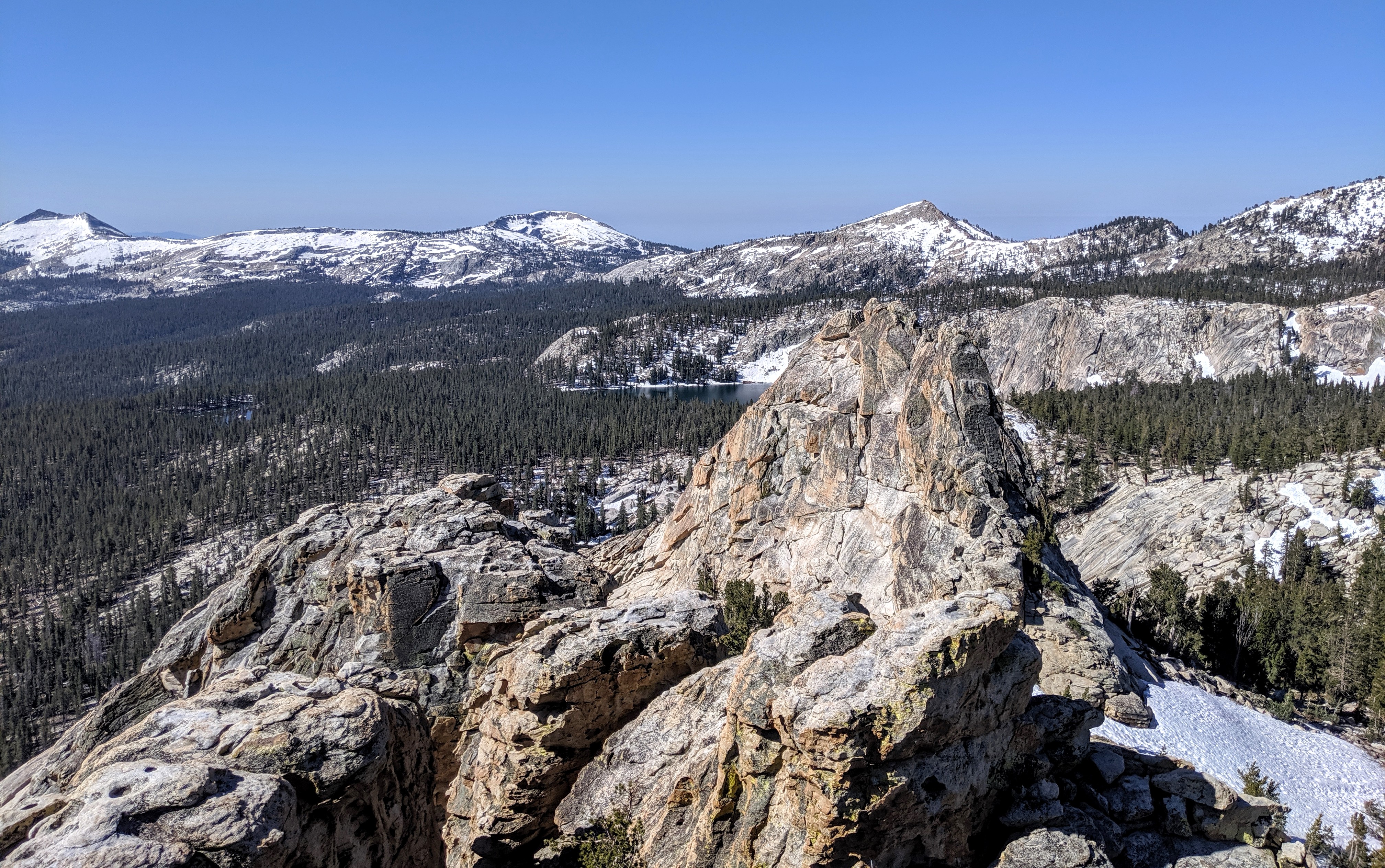
The next morning we hiked up to the top of Dogtooth Peak. We initially headed up along the path toward Rock Pass, but once atop the ridge we took the more direct path north/northeast and found easy walking up to the top. Only the final 20 feet or so required the use of both hands, and we enjoyed great 360 degree views.
We took the direct route due south back to camp, where we packed up and headed out after eating an early lunch. 2 hours later we were back at the Nelson Creek crossing, and shortly after that we were back at the truck. Not a whole lot to report, but it was a great first backpack of the year and a useful warmup for longer trips later in the season.
The latest high res satellite image on 7/1 showed things looking up: Bullfrog Lake was ice-free, and the road from the Courtright dam to the Cliff Lake trailhead looked snow-free too. I was still worried about the Nelson Creek crossing, especially as one person in our group wasn't a very experienced backpacker. But then on July 3 Mav re-posted a conditions update from someone who had just been in the area and who confirmed that there was a crossing 100 yards upstream of Nelson Creek that was only knee-deep. We were good to go.
The Clovis FS headquarters was closed on July 4 for the holiday, so I made the drive up to Prather to pick up our walk-in permits for July 5 when the office opened at 8:00am. We got there a few minutes late, and there were already 4 parties in front of me. I tried my hardest to eavesdrop on their conversations to ascertain whether or not I'd be able to snag my permits -- I needed 5 of the 8 available. 20 minutes later I got to the front, picked up the permit, and headed back to enjoy the rest of my 4th.
On Friday morning, we fueled up in Sanger and drove up to Courtright. I haven't driven past the Dinkey Road turnoff in over 15 years, so it was a fun drive peering around every corner trying to reacquaint myself with my surroundings. We got to the Cliff Lake trailhead after 2.5 hours, surprised by the number of cars in the parking lot, and geared up. Mosquitoes were about a 2-3.
The hike down to Nelson Creek was straightforward and thankfully downhill. This was our first backpack of the season, so in good hiking shape we were not. Upon arriving at the creek, we turned upstream and, just as expected, a much more mellow section appeared in about 100 yards. We forded and none of our oxen died. The water was cold as snow. The first two seconds were pleasant, the next three were tolerable, and then the following 5 were highly uncomfortable. Had the crossing taken longer than 10 seconds, who knows how I'd describe it. I'd been reading all of the cautionary threads on HST about stream crossings and the much more significant danger posed by water than by snow, so the risk was very present in my mind.
The rest of the hike up to Cliff Lake was snow-free and iffy stream crossing-free. I'd never hiked this trail before, so I was surprised by how gradual it is. There were a handful of groups coming back down, and we passed a few groups going up. Once we hit the Cliff Lake turnoff, we veered off-trail a bit and hooked up with the unmaintained trail to Bullfrog. We had the lake to ourselves (saw several folks going to/coming from Cliff) so we took our time and found a good well-used campsite on the northeast corner and set up camp there.
I stopped to fish a bit and the rest of my party decided to spend the afternoon relaxing around the lake, but I had designs on further exploration so I headed out to check out the rest of the Dinkey Lakes. Up to Rock Pass was snow-free, but on the north side of the pass the trail disappeared in snow. I continued down to Rock, where the lake was about 1/4 frozen. My goal was to visit Island so I was tempted to head directly there (SW of Rock), but the slope was covered in a solid snow field with a steep gradient so I thought better of it and headed the long way around Rock. Once I was due W of Rock I headed straight toward Island, crossing several more snow fields until I topped out on the small cliffs above Island's eastern shore.
Island was still about 75% covered in ice, with most open water on the southwest corner and western fringe. I circumnavigated the lake clockwise, hopping across the one narrow part of the swollen inlet creek, and trying a bit of fishing. No luck, though a few people camped at the lake told me they saw a fish. I headed back around 6:30pm and got back to Bullfrog an hour later, in time for a hearty dinner and drinks at camp. Mosquitoes were present but not bad at all -- I imagine they'll be much worse very soon.
The next morning we hiked up to the top of Dogtooth Peak. We initially headed up along the path toward Rock Pass, but once atop the ridge we took the more direct path north/northeast and found easy walking up to the top. Only the final 20 feet or so required the use of both hands, and we enjoyed great 360 degree views.
We took the direct route due south back to camp, where we packed up and headed out after eating an early lunch. 2 hours later we were back at the Nelson Creek crossing, and shortly after that we were back at the truck. Not a whole lot to report, but it was a great first backpack of the year and a useful warmup for longer trips later in the season.