Re: TR-North Lake to McGee Creek
Posted: Mon Aug 29, 2016 9:20 am
No wonder you had trouble beyond White Bear Lake. Your image shows the view from Brown Bear Lake up towards what is called Whitebear or sometime Brown Bear Pass, one of the trickiest class 2 passes in the range.
http://mapper.acme.com/?ll=37.34042,-118.80044&z=15&t=T
Most groups going from EF Bear Creek Basin to Lake Italy use Dancing Bear Pass that drops down to Jumble Lake.
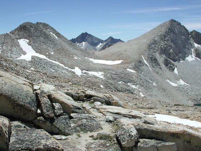
This picture shows the view south towards Dancing Bear Pass:
http://www.thewyants.com/hikes/sierra03/dscn0158b.jpg
I've camped at Brown Bear Lake on a couple backpacking trips and into the EF Bear Creek basin a few times. Whitebear Pass is not even listed on our HST passes sub forum and probably should remain so because most would get into class 3 terrain. Everything right below the pass is class 3 including the least steep choice a bit north because of a steep band between 11500 and 11700 that is not visible from the top. Of course a whole lot of people only really ever use visual sight to figure out their routes that in my opinion is a huge mistake and this pass is a prime example where a concave slope that looks ok from the top conceals the steepest sections below. One will also not find anything really usable about the route elsewhere on the web because DBP is also less total vertical uphill if one is continuing either over Italy or Gabbot passes. One does need to climb up from Whitebear Lake to reach DBP but that is less than one climbs from the Brown Bear Lake outlet to Lake Italy.
The first time I went over the pass, I had the advantage of looking up from Brown Bear Lake and could see the route I had drawn from topo studies before my trip. The trick if going north is to at pass level first traverse north all the way to what shows on the topo as an intermittent stream. The traverse is actually on an easy ramp. One crosses that stream and then descends directly all the way down. Looking at the topo lines one can see though steep, it is significantly less so than anywhere else.
Likewise a careful topo map study of Carol Col even without any other advice clearly shows the route below that rlown discusses is less steep.
Also note HST has a page for Carol Col:
viewtopic.php?f=31&t=7686
http://mapper.acme.com/?ll=37.34042,-118.80044&z=15&t=T
Most groups going from EF Bear Creek Basin to Lake Italy use Dancing Bear Pass that drops down to Jumble Lake.
This picture shows the view south towards Dancing Bear Pass:
http://www.thewyants.com/hikes/sierra03/dscn0158b.jpg
I've camped at Brown Bear Lake on a couple backpacking trips and into the EF Bear Creek basin a few times. Whitebear Pass is not even listed on our HST passes sub forum and probably should remain so because most would get into class 3 terrain. Everything right below the pass is class 3 including the least steep choice a bit north because of a steep band between 11500 and 11700 that is not visible from the top. Of course a whole lot of people only really ever use visual sight to figure out their routes that in my opinion is a huge mistake and this pass is a prime example where a concave slope that looks ok from the top conceals the steepest sections below. One will also not find anything really usable about the route elsewhere on the web because DBP is also less total vertical uphill if one is continuing either over Italy or Gabbot passes. One does need to climb up from Whitebear Lake to reach DBP but that is less than one climbs from the Brown Bear Lake outlet to Lake Italy.
The first time I went over the pass, I had the advantage of looking up from Brown Bear Lake and could see the route I had drawn from topo studies before my trip. The trick if going north is to at pass level first traverse north all the way to what shows on the topo as an intermittent stream. The traverse is actually on an easy ramp. One crosses that stream and then descends directly all the way down. Looking at the topo lines one can see though steep, it is significantly less so than anywhere else.
Likewise a careful topo map study of Carol Col even without any other advice clearly shows the route below that rlown discusses is less steep.
Also note HST has a page for Carol Col:
viewtopic.php?f=31&t=7686