Page 3 of 7
Re: 2016 Backcountry Conditions Reports
Posted: Fri May 27, 2016 2:38 pm
by marymaryland
Looking forward to a report from BlueWater's report and pictures-- I'm headed to Center Basin next week. Sounds like I shouldn't even bother bringing skis?! I'll post my own report about Center Basin when I get back.
White Wolf to Tuolumne Meadow 5/23-5/27
Posted: Sat May 28, 2016 6:07 pm
by cinestir
May 23-27. White Wolf to Pate Valley to Tuolumne Meadows: Patchy snow above 7000ft, but easy and safe to get over/around. All creeks crossable with some knee high wading at Register Creek as of the 25th. Some light flooding of trails coming up out of Pate Valley. "The marsh" is about knee high as well. Lots of poison oak in the valley.
Re: 2016 Backcountry Conditions Reports
Posted: Sun May 29, 2016 12:42 pm
by maverick
Please update the "Subject" tab with the location and dates of your trip.
Thank you.
5/28 - 5/30 NE of Graveyard Meadows
Posted: Mon May 30, 2016 8:37 pm
by RoguePhotonic
Took a trip up to Arrowhead and Feather Lakes NE of Graveyard Meadow. In the trees around Graveyard 60% snow coverage. At 9800 feet and above 95-100% snow coverage 3 feet deep.
Lodgepole to Twin Lakes 5/28 - 5/30
Posted: Tue May 31, 2016 5:18 pm
by robow8
Silliman Creek below knee wade. A little patchy snow below Cahoon Gap, mostly snow on the North side to Clover Creek. Patchy snow and lots of snowmelt on the trail th Twin Lakes, becoming all snow just below the lakes. Some bare patches around the lakes, which are partially frozen. 3 feet of snow in the shade.
5/29: Desolation Wilderness- Lake Sylvia
Posted: Tue May 31, 2016 7:54 pm
by ksenn
Route taken: Lyon's Creek Trail to Lake Sylvia
Difficult section encountered: Trail is a running stream or swamp if not covered in snow. Patchy snow below 7400ft increasing to 100% coverage around 7800ft. Lake is mostly frozen over, starting to melt around the edges. Lyons creek is high and fast. Postholed a few times up to my thighs.
Special equipment needed/used: None, but may want waterproof footwear if adverse to getting wet feet.
DSC04972(2).JPG
DSC04982(2).JPG
DSC04981(2).JPG
DSC04977(2).JPG
Clouds Rest 5/26 - 5/30
Posted: Tue May 31, 2016 7:58 pm
by oliverlu
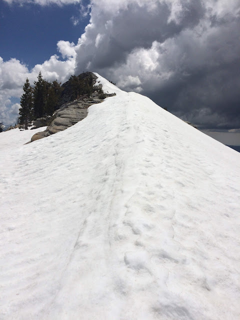
Approached from North, patches of snow on south facing fire-burned area beginning at 8700. Full consolidated coverage at 9,000. 3-4' consolidated knife ridge of snow covering the granite steps leading towards summit at 9,900'. South approach mostly clear with sporadic patches of snow.

Chicken Spring Lake 5/28 / Shepherd Pass Trail 5/29
Posted: Tue May 31, 2016 8:09 pm
by dougieb
5/28 Hiked from horseshoe meadows to Chicken Spring Lake and then just above the lake to look west. There was very little snow on the trail until Chicken Spring Lake which was mainly frozen. About a 50/50 spread between dry and snow covered areas. Looking to the west, golden trout meadows down there had very little to no snow from what I could see.
5/29 Hiked along Symmes Creek on the Shepherd's Pass trail and it was beautiful. The water is flowing pretty well but it is all below knee high and easy to cross. There was no snow for us but we only went to about 7000 feet so duh. Snow looked like it was peppered around 10,500 in that drainage.
Sabrina Basin 5-26 through 5-29
Posted: Wed Jun 01, 2016 10:21 am
by snevill
Hiked out of Lake Sabrina to Blue Lake. The trail was under snow in a number of places and there were a number of spots with precarious snow crossings. Blue Lake was mostly frozen and the surrounding areas had about 50% snow coverage. The trail to Dingleberry Lake required a detour around a steep snow crossing. We didn't venture beyond Dingleberry due to the conditions (and incoming weather).
Re: 2016 Backcountry Conditions Reports
Posted: Wed Jun 01, 2016 5:36 pm
by ExploreABitMore
Looks like a forest fire in the Kennedy Meadows area just started up. Didn't notice it around lunch time, came out to go home and there it was. Looks to be just a little north of Sawtooth Peak.
