Fellow Members,
Would like to bring the following precautionary warning to anyone planning to go backpacking into
the Sierra early this Spring season because of the drought conditions and the low snow levels
that currently exist, especially those of you who are relatively new to backpacking, don't let these
conditions make you complacent.
Be prepared for all conditions and do not underestimate mother nature, April and May can bring
surprise winter storms into the Sierra bringing cold temps and snow that covers the trails, check
several weather sources before heading out and if going out for several days be prepared,
have an evac plan in place, and leave an itinerary back home so you don't become a SAR inicdent.
Warning
-
maverick

- Forums Moderator

- Posts: 11834
- Joined: Thu Apr 06, 2006 5:54 pm
- Experience: Level 4 Explorer
Warning
Professional Sierra Landscape Photographer
I don't give out specific route information, my belief is that it takes away from the whole adventure spirit of a trip, if you need every inch planned out, you'll have to get that from someone else.
Have a safer backcountry experience by using the HST ReConn Form 2.0, named after Larry Conn, a HST member: http://reconn.org
-
The Other Tom

- Founding Member
- Posts: 970
- Joined: Mon Dec 19, 2005 6:06 pm
- Experience: N/A
- Location: Upstate South Carolina
Re: Warning
Very timely Mav
From the Nat'l weather service:
345 am pdt sat apr 4 2015
Caz096-097-051200-
Sierra nevada from yosemite to kings canyon-
Tulare county mountains-
345 am pdt sat apr 4 2015
This hazardous weather outlook is for the higher elevations of
The southern sierra nevada.
...Snow accumulations in the sierra tuesday through wednesday...
.Day one...Today and tonight
No hazardous weather expected.
.Days two through seven...Sunday through friday
* snow accumulations: up to a foot of snow is possible at the
Highest elevations by wednesday evening...With a few inches
Possible down around 5000 feet.
* elevation: snow levels lowering to around 4000 feet.
* timing: snow beginning tuesday with the heaviest snow tuesday
Evening into early wednesday morning...Then tapering off
Wednesday.
* impacts: visitors and outdoor enthusiasts to yosemite national
Park...Sequoia and kings canyon national parks...Devils
Postpile national monument as well as the sierra national
Forest...Sequoia national forest and mountain home state forest
Should be prepared for snow and colder temperatures. Roads can
Become slick and icy.
* stay tuned to noaa weather radio...Or your favorite news
Source...For further information.
.Spotter information statement...
Skywarn spotter activation is not anticipated.
Weather spotters are encouraged to report any significant or
Unusual conditions to the national weather service.
$$
-
balzaccom
- Topix Addict
- Posts: 2966
- Joined: Wed Dec 17, 2008 9:22 pm
- Experience: N/A
Re: Warning
God, I hope this is a huge storm....
Check our our website: http://www.backpackthesierra.com/
Or just read a good mystery novel set in the Sierra; https://www.amazon.com/Danger-Falling-R ... 0984884963
Or just read a good mystery novel set in the Sierra; https://www.amazon.com/Danger-Falling-R ... 0984884963
-
DoyleWDonehoo
- Founding Member
- Posts: 480
- Joined: Wed Dec 14, 2005 2:06 pm
- Experience: N/A
- Location: San Jose, CA
- Contact:
Re: Warning
This is what concerns me. Sooner or later there will be a wet "normal" or extreme winter. Meanwhile there are people who have been backpacking in just the last 5 years. What they have never experienced is a serious winter runoff, one that extends into August. Then suddenly river and stream crossings become very serious business. Hopefully by then we are all raising awareness of this very real hazard and people will be prepared.
Doyle W. Donehoo
Sierra Trails:
http://www.doylewdonehoo.com" onclick="window.open(this.href);return false;
Sierra Trails:
http://www.doylewdonehoo.com" onclick="window.open(this.href);return false;
-
Tom_H
- Topix Expert
- Posts: 795
- Joined: Tue Jul 10, 2012 1:11 pm
- Experience: Level 4 Explorer
- Location: Camas, WA
Re: Warning
I concur. This is a dangerous season to be out and what looks like benign conditions can quickly become treacherous. Here in the valley it was hot enough for shorts yesterday, yet it poured freezing rain and even hail for awhile today. Weather forecasts can give you a window of a couple of days for a short trip, but heading deep into the backcountry this time of year is risky. A huge system could come in with less than five days notice and bury a party under many feet of snow. Hypothermia is a dangerous condition, one that can seduce people without them realizing what is happening. At this time of year, the only people who should head deep into the backcountry are those who are experienced in such conditions and who have the correct equipment for winter camping. Be safe out there. Maverick and others here already spend too much time organizing and carrying out search efforts.
-
SSSdave
- Topix Addict
- Posts: 3524
- Joined: Thu Nov 17, 2005 11:18 pm
- Experience: N/A
- Location: Silicon Valley
- Contact:
Re: Warning
Looks like winter again!
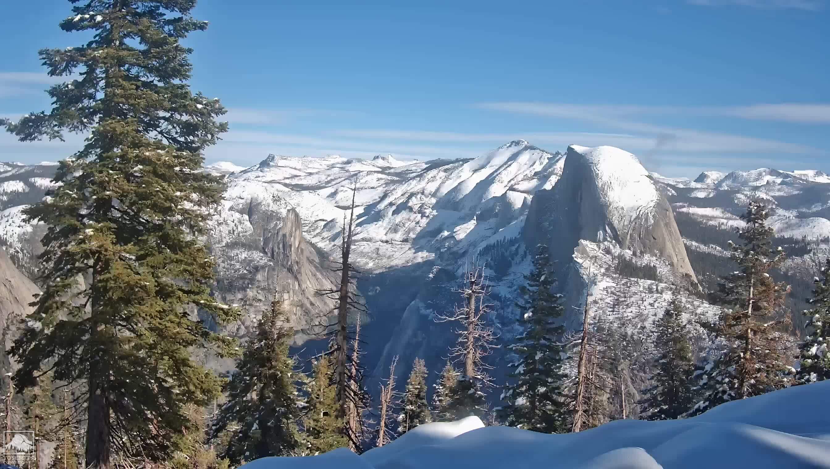
(courtesy yosemiteconservancy.org site)
Storm came through nicely for a change this winter. Checked several CDEC remote gauges showing nice totals of a half inch to two inches precip. Not much left reached far southern Sierra areas and SoCal just received minor showers. Two feet of fresh snow up at Carson Pass today and generally at least a foot at the Tahoe region ski resorts. Even if it gets dry again, will do a lot for the usual vegetation sequence going into May for the lower Sierra forest elevations.
Elsewhere about most lower elevations of California to the west spring wildflower season has already played out much earlier than usual so this rain won't have much affect. Really had outstanding days out in the field this last couple months chasing wildflowers that am now just finishing up a large feature chronology for my website on. Wildflowers up on the central and north coast bluff areas are just now nearing peak if one can pick days without northwesterlies.
NWS is looking at another smaller Gulf Of Alaska low that may move down into California next week so lets hope that holds up.
David
-
tomba

- Topix Regular
- Posts: 375
- Joined: Sat Jun 18, 2011 12:50 pm
- Experience: Level 4 Explorer
- Location: Bay Area
Re: Warning
That image is black right now (at night). Here is an image from earlier today:

Taken from http://rockyags.cr.usgs.gov/cgi-bin/cam ... ible=false
Taken from http://rockyags.cr.usgs.gov/cgi-bin/cam ... ible=false
-- Found trash? Please pack it out. Thank you.
Who is online
Users browsing this forum: divination and 28 guests