Hi Rich,
Going over the shoulder is the easiest way to gain access into Red Spur Lakes Basin,
and there are several lakes that deserve a photographers attention. If my schedule
allows, meaning getting 9 days off, then I plan on spending 2-3 days in RSLB, especially
if there is some weather disturbance or at least clouds in the area that can be
conducive to some quality light.
No fish in the lakes.
Maverick's 2015 Annual HST Meet-Up 7/22-7/24/15
-
maverick

- Forums Moderator

- Posts: 11835
- Joined: Thu Apr 06, 2006 5:54 pm
- Experience: Level 4 Explorer
Re: Maverick's 2015 Annual HST Meet-Up 7/22-7/24/15
Professional Sierra Landscape Photographer
I don't give out specific route information, my belief is that it takes away from the whole adventure spirit of a trip, if you need every inch planned out, you'll have to get that from someone else.
Have a safer backcountry experience by using the HST ReConn Form 2.0, named after Larry Conn, a HST member: http://reconn.org
-
richlong8

- Topix Expert
- Posts: 839
- Joined: Tue Nov 25, 2008 6:02 pm
- Experience: Level 4 Explorer
Re: Maverick's 2015 Annual HST Meet-Up 7/22-7/24/15
Thanks, it looked like going to the meetup lake first was the best approach. I will probably try to at least get one sundown and one sunrise there.
-
maverick
- Forums Moderator
- Posts: 11835
- Joined: Thu Apr 06, 2006 5:54 pm
- Experience: Level 4 Explorer
Re: Maverick's 2015 Annual HST Meet-Up 7/22-7/24/15
Yes it is, especially coming from the east.Rich wrote:
Thanks, it looked like going to the meetup lake first was the best approach.
There are some great photo opportunities in the upper part of the KB, also from the
ridge between Picket Creek and Kaweah Basin.
The ridge line extending from just south of Mt. Kaweah to about half the length of
the ridge extending towards Kaweah Queen can be bathed in a beautiful Alpine Glow
in the morning hours.
Some of the small lakes/ponds, and view points on the previously mentioned ridge line
(between Picket-Kaweah Basin), should have outstanding opportunities in the morning
hours, and if enough clouds are present, then at sunset too.
In Red Spur Lakes Basin most of the action is at sunset, the Whitney Range can glow
in a beautiful warm light at sunset, and if you locate an ideal lake that gives you the
perfect reflection of this magnificent show, like some of the lakes towards the southern
end of the basin, a photographer can be well rewarded for their efforts.
Professional Sierra Landscape Photographer
I don't give out specific route information, my belief is that it takes away from the whole adventure spirit of a trip, if you need every inch planned out, you'll have to get that from someone else.
Have a safer backcountry experience by using the HST ReConn Form 2.0, named after Larry Conn, a HST member: http://reconn.org
I don't give out specific route information, my belief is that it takes away from the whole adventure spirit of a trip, if you need every inch planned out, you'll have to get that from someone else.
Have a safer backcountry experience by using the HST ReConn Form 2.0, named after Larry Conn, a HST member: http://reconn.org
-
SSSdave
- Topix Addict
- Posts: 3524
- Joined: Thu Nov 17, 2005 11:18 pm
- Experience: N/A
- Location: Silicon Valley
- Contact:
Re: Maverick's 2015 Annual HST Meet-Up 7/22-7/24/15
Completed an updated plan for a 2015 8 or 9 day backpack over Shepherd Pass. As noted previously, won't be joining the rest of you for reasons given. I won't set the dates until later April when I can assess the winter snowpack in order to be up there at peak greenery and wildflowers which ought to also be in the late stages of mosquito season. If the winter is average will likely set dates of August 1 through 9 that will be after the group trip.
Since I will be carrying less weight than when I planned this out 3 years ago, changed my plan to get over Shepherd in just 2 full days. Have now reviewed the mileage to the pass given changes in the inaccurate topo switchback section noted previously on a http://www.summitpost.org" onclick="window.open(this.href);return false; thread which adds another 0.5 miles to the distance to the 2760+ meter ridge point.

elev.....up.....down....miles
--------------------------------------------
6,300
9,080...2780............3.7 ridge crossing
8,990...........90
9,070.....80
8,500...........570.....4.7
8,920....420............5.9
9,150....230............6.3 Mahogany Flat
10,040...890............8.0 Anvil Camp
10,810...770............9.2 The Pothole
12,040..1230...........10.5 Shepherd Pass
----------------------------------------
........6400 feet......10.5 miles
Measurements were done using my usual 1/4 mile pencil marking on a topo. So if this trip happens, will pick up my permit as soon as possible after the Whitney ranger station opens at 8am on a Saturday given the Sequoia NP sermon policy then drive back north the 18 miles to Lone Pine, 4 miles up the Onion Valley Road then the 4 miles on that ugly dirt road. Which means probably getting on the trail by a hot 9:30am which is horrible. In any case my uphill hiking style carrying low 60's pounds is slow with lots of breaks and napping. (:
Snippet from summitpost.org:
Shepherd Pass (6400'). From Independence, drive west on Market Street for 4.2 miles, before turning left on Foothill Road (gravel). The road forks after 1.3 miles; take the right fork, and continue on this main road, ignoring side roads. Continue about 1.5 miles further to a corral and a sign saying "Symmes Creek"; turn left here.
After another 0.5 miles, you'll reach a signed junction for the Shepherd Pass trail; turn right here, and follow the road to the trailhead, keeping right at both forks. The road is passable, with some care, to most passenger cars. This trail is used to access Mt. Tyndall, Mt. Williamson, Junction Peak, as well as peaks in the Sequoia NP backcountry around the upper reaches of the Kern River (Milestone Mtn., Midway Mtn., etc.). Although this trail has a reputation for being a hard hike, it is well-graded, and is generally one of the more pleasant of the high passes.
My own trip now will spend the second night Sunday at one of the lakes near Shepherd Pass so I might get something late of Williamson and Tyndal from 3806. Then dawn speed down to the Wrights Creek meadows Bighorn Plateau zone where I will semi base camp 3 nights at spots giving me 3 afternoons and 2 mornings for photography. And note that is way lower in those drainages than where you folks went this summer. Then day 6 dawn will ramble over to the Upper Kern Basin for 1 or more likely 2 nights before making the 2 day return leg.
Since I will be carrying less weight than when I planned this out 3 years ago, changed my plan to get over Shepherd in just 2 full days. Have now reviewed the mileage to the pass given changes in the inaccurate topo switchback section noted previously on a http://www.summitpost.org" onclick="window.open(this.href);return false; thread which adds another 0.5 miles to the distance to the 2760+ meter ridge point.
elev.....up.....down....miles
--------------------------------------------
6,300
9,080...2780............3.7 ridge crossing
8,990...........90
9,070.....80
8,500...........570.....4.7
8,920....420............5.9
9,150....230............6.3 Mahogany Flat
10,040...890............8.0 Anvil Camp
10,810...770............9.2 The Pothole
12,040..1230...........10.5 Shepherd Pass
----------------------------------------
........6400 feet......10.5 miles
Measurements were done using my usual 1/4 mile pencil marking on a topo. So if this trip happens, will pick up my permit as soon as possible after the Whitney ranger station opens at 8am on a Saturday given the Sequoia NP sermon policy then drive back north the 18 miles to Lone Pine, 4 miles up the Onion Valley Road then the 4 miles on that ugly dirt road. Which means probably getting on the trail by a hot 9:30am which is horrible. In any case my uphill hiking style carrying low 60's pounds is slow with lots of breaks and napping. (:
Snippet from summitpost.org:
Shepherd Pass (6400'). From Independence, drive west on Market Street for 4.2 miles, before turning left on Foothill Road (gravel). The road forks after 1.3 miles; take the right fork, and continue on this main road, ignoring side roads. Continue about 1.5 miles further to a corral and a sign saying "Symmes Creek"; turn left here.
After another 0.5 miles, you'll reach a signed junction for the Shepherd Pass trail; turn right here, and follow the road to the trailhead, keeping right at both forks. The road is passable, with some care, to most passenger cars. This trail is used to access Mt. Tyndall, Mt. Williamson, Junction Peak, as well as peaks in the Sequoia NP backcountry around the upper reaches of the Kern River (Milestone Mtn., Midway Mtn., etc.). Although this trail has a reputation for being a hard hike, it is well-graded, and is generally one of the more pleasant of the high passes.
My own trip now will spend the second night Sunday at one of the lakes near Shepherd Pass so I might get something late of Williamson and Tyndal from 3806. Then dawn speed down to the Wrights Creek meadows Bighorn Plateau zone where I will semi base camp 3 nights at spots giving me 3 afternoons and 2 mornings for photography. And note that is way lower in those drainages than where you folks went this summer. Then day 6 dawn will ramble over to the Upper Kern Basin for 1 or more likely 2 nights before making the 2 day return leg.
-
Wandering Daisy
- Topix Docent
- Posts: 6689
- Joined: Sun Jan 24, 2010 8:19 pm
- Experience: N/A
- Location: Fair Oaks CA (Sacramento area)
- Contact:
Re: Maverick's 2015 Annual HST Meet-Up 7/22-7/24/15
I am still waiting on the date for the NOLS 50th year reunion in Lander Wyoming this summer. I am DEFINITELY going to that! Plus I will do a 10-day Wyo backpack when there. If the meet-up does not conflict, I will plan on being there.
-
Hobbes
- Topix Fanatic
- Posts: 1120
- Joined: Wed Apr 27, 2011 8:09 am
- Experience: N/A
- Location: The OC
Re: Maverick's 2015 Annual HST Meet-Up 7/22-7/24/15
Your 10.5 looks closer to the mark. Having been up/down a couple of times, I always thought the distance between the top of the ridge and the bottom was longer than noted. (Then again, maybe it's just perception as you have to climb out almost 600' while thoroughly tired.)
As for those lakes at the pass, I do believe the upper Tyndall plateau might win the most forlorn, windswept and barren place in the Sierra award. It's similar to the way PCTers describe hiking across Tehachapi pass - you pop out over the pass, where the canyon is generally calm & warm and boom - hold onto your hat. Going the other way, it's like a mini, depressing ordeal until you literally drop over a small ledge and are basked in the warmth of the canyon.
I think you'll really like Wright lakes basin - I was really impressed by the extensive meadows and easy hiking. Will you be going over Rockwell? That would make a nice little loop either heading back over Bighorn (Mav's route) or continuing down to the PCT. From there, you could drop down to the Kern on the HST, and then hit Milestone on the way back out.
-
Wandering Daisy
- Topix Docent
- Posts: 6689
- Joined: Sun Jan 24, 2010 8:19 pm
- Experience: N/A
- Location: Fair Oaks CA (Sacramento area)
- Contact:
Re: Maverick's 2015 Annual HST Meet-Up 7/22-7/24/15
Last year I went over Rockwell - it now has a pretty distinct use-trail all the way up on the north side, if you can find it from the bottom. Fishing was great at the ugly lakes just below the pass on the south side. I say ugly because the water quality was so bad I wondered how fish could live in it.
I have camped at one of the lakes just as you top over the pass. I guess I was lucky - it was not that windy.
I find Shepherd Pass a mental issue. Just as you finish the grueling first uphill you have to go down! So I do a lot of internal "pep talks" to myself. I focus on the nice rest I am getting going down, and put the going back up out of my head. In fact on all the long east side passes, I find that an "in the moment" attitude helps a lot, plus I do not look up! I look back to see how far I have come instead. Sort of get into a "zen" place, one foot in front of the other. I also trick myself by planning to camp part way up a pass (a more reasonable goal), and get to my initial destination soon enough that I actually go all the way over the pass. Another key to success is a pre-dawn start to beat the heat. I tend to totally wilt in the heat.
I have always camped at the upper flat above the Pot Holes, at the edge of timber. I do not get too obsessed with actual mileage given in guide books or on trail signs. Some are quite inaccurate. Time needed is more important than miles, and that is variable depending on my mood, the weather, how well I slept the night before, etc, etc, Two days to get to destinations on the other side of Shepherd Pass seems quite reasonable. Luckily there are choices of campsites before you get to the pass and after you get over.
-
freestone

- Topix Expert
- Posts: 963
- Joined: Fri Nov 11, 2005 9:42 pm
- Experience: Level 3 Backpacker
- Location: Santa Barbara
- Contact:
Re: Maverick's 2015 Annual HST Meet-Up 7/22-7/24/15
...And speaking of ugly, lets not forget about that deep wash out gash just before Anvil holding an assortment of nasty surprises and challenges for the weary traveler.
Short cuts make long delays. JRR Tolkien
-
SSSdave
- Topix Addict
- Posts: 3524
- Joined: Thu Nov 17, 2005 11:18 pm
- Experience: N/A
- Location: Silicon Valley
- Contact:
Re: Maverick's 2015 Annual HST Meet-Up 7/22-7/24/15
The following ought to give some understanding as to why my usual detailed itinerary plans are often too strange to backpack with others with. Well except for serious photographers buying in to the same strategy. Yeah upper Tyndall images look desolate. Given the sw to ne trend it is the perfect angle for unblocked winter storm winds. After my 3k+ climb on the second day to the pass by early pm, am likely to be rather dead so will nap a few hours by lake 3580+ wsw of the pass.
http://mapper.acme.com/?ll=36.67262,-118.35815&z=15&t=T" onclick="window.open(this.href);return false;
If in the very unlikely event late afternoon breezes are calm, might climb to get a Williamson and Tyndall image from lake 3800+ meters nw of the pass. More likely with refreshed energy about 4pm will leave my backpack and climb up the 600 foot class 2 south point of Diamond Mesa and find a perspective at the brink near where the "P" in PARK shows on the topo. That way I get the lake I was napping at below and Tyndall and Williamson are nicely separated enough for a normal lens angle view though will like most serious pics on that trip use my robotic head for a multi row-column stitch. Although that is also a good angle for late light as the sun sets maybe 27 degrees north of due west, I won't bother with staying up there beyond about 6:30pm as my plan is also to be back in that zone on the return leg. Besides although the two peaks get more interesting light towards 7pm plus, the lower frame landscapes will loose definition because the angle is too directly front lit. So will be back at my pack by about 7pm. That will leave me an hour to ramble down by dusk, the 2.5 miles to the lake chain on the bench nw of Tawny Point where I would be asleep by 9:30pm.
The third morning would rise by 5am, break camp, and ramble down the PCT till vectoring off at the popular pond next to the trail on Bighorn Plateau. From there will continue to a location down in the foxtail pines with water further to the sw on this feature, drop my pack, and then work all morning and afternoon up on this uniquely unusual landscape that has superb am perspectives with foxtail foregrounds of the Great Western Divide and Kaweah Peaks Ridge and crest perspectives in the pm.
Fourth morning will move down to the lower Wrights Creek Meadows where I've id'd a good perspective towards the big peaks to the east and drop gear for later camp while continuing up the creek for a view down at lake 3380+ from above towards Kaweah Peaks Ridge. Back at my campspot, midday is usually the main meal of the day, gear work, and rest. After some 4pm to 5pm pics about the meadows will do the class 1 climb up the sw slope of Barnard to 12300 for a optimal 6pm view of Whitney, Hale, and Young with Wales, and Wallace below. The other parts of my trip are like detailed with lots of red pencil map marks showing image perspectives.
David
-
Hobbes
- Topix Fanatic
- Posts: 1120
- Joined: Wed Apr 27, 2011 8:09 am
- Experience: N/A
- Location: The OC
Re: Maverick's 2015 Annual HST Meet-Up 7/22-7/24/15
You'll have a blast. With that kind of dedication getting to good vantage spots, I'm sure you'll get many fantastic photos. I take along a Sureshot just to record some visual trail notes, and even I can pull off a generic alpenglow photo of Barnard from the 'pothole' lake in WLB.

Btw, the southwest shoulder of Barnard is difficult terrain. I thought I was going to short-cut the route on the way to Wales, but it's within treeline and covered with large boulders (the edge leading up is visible on the left in the photo below). I had been advised that heading almost to the PCT down this meadow was easier, but didn't become a believer until I was actually standing there:
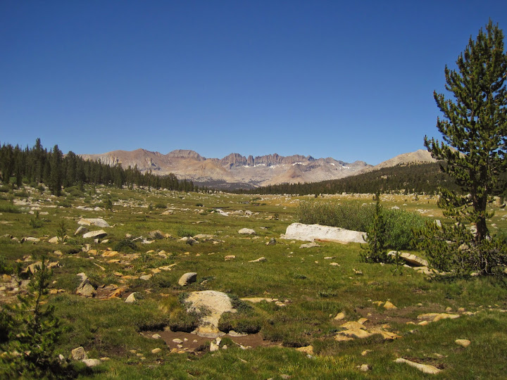
Btw, the southwest shoulder of Barnard is difficult terrain. I thought I was going to short-cut the route on the way to Wales, but it's within treeline and covered with large boulders (the edge leading up is visible on the left in the photo below). I had been advised that heading almost to the PCT down this meadow was easier, but didn't become a believer until I was actually standing there:
Who is online
Users browsing this forum: No registered users and 70 guests