Getting ready for my first trip to the Sierra! I will be doing the High Sierra Trail solo from Crescent Meadow (well, actually the Lodgepole Visitor Center) to Whitney Portal from Sept 18th – 22nd. I have scoured the internet for trip reports so I have a pretty good sense of what to expect. The forums here have been the most valuable so I was hoping for some specific insight on my planned itinerary.
A little background: I have a decent amount of solo experience, all on the east coast. I have only done 1 trip out west way back in high school; an Outward Bound course in Colorado in ’92. I have been working to get my pack weight down over the last several years. I am looking at a 14 lb base weight (pack – consumables), with food, fuel and water I should start off with a pack weight around 24 lbs. My gear list is available here: http://lighterpack.com/r/6k4zkg" onclick="window.open(this.href);return false;. Although it pains me in the pack-weight I will be carrying a bear canister.
Since lightening my load I do not have an issue covering 15-20 miles/day. Of course that is all on the east coast. I don't move particularly quickly but when soloing I usually hike from sun up to sunset. I am used to the elevation changes but the altitude is something I am not accustomed to. I will be spending two nights in Tahoe and another in Visalia before setting out which will give me some time to acclimate.
I am comfortable with scrambling (class 3 terrain) and know how to read a map and compass but do not have any route-finding experience in the western sense. I am fairly comfortable with river crossings (I don’t expect them to be too difficult in Sept). I would say I am a level 3 backpacker and comfortable with any terrain except snow/glaciers.
I will be hiking from the Lodgepole visitor center to the trailhead at Crescent Meadow as I couldn't pass up the opportunity to see some of the parks frontcountry sights. I have about 6 miles before reaching the trail. Here are my planned campsites.
Day One – Bearpaw Meadow (17.5 Miles, +2,800/-1,800 Feet)
Day Two – Moraine Lake (19.0 Miles, +3,500 Feet/-3,000 Feet)
Day Three – Junction Meadow (14.5 Miles, +1,300/-2,600 Feet)
Day Four – Tarn above Guitar Lake (12.0 Miles, +4,400/-800 Feet)
Day Five – Whitney Portal (16.0 Miles, +3,200/-7,300 Feet)
I mapped the route out on Trimble Outdoors, which is available below:
http://www.trimbleoutdoors.com/ViewTrip/2761793" onclick="window.open(this.href);return false;
I would love to make it to Hamilton on the first day. It looks like the most photogenic spot on the entire trail. I would also love to do the first big climb in the early hours when it will be cooler. That being said, with the extra 6 miles to the trailhead I don’t think I can pull it off. If I am feeling strong and it is early enough when I reach Bearpaw would pushing on to Hamilton be worth it? Will the crowds have cleared out by September 18th (a Wednesday)?
The other alternative I am looking at for Day One is Buck Creek. Is this a better alternative to Bearpaw Meadow? I read that some people can’t seem to find the campsites here, is there some trick or does it have more to do with their definition of a “campsite”?
Day Two is probably the toughest day on my itinerary. I was planning on taking the first (longer) trail to Moraine and then looping back onto the trail after Moraine Lake. Would I be missing any ‘must see’ spots on the High Sierra Trail by taking this side loop? Does anybody have suggestions for alternate sites if I don’t make it all the way to Moraine Lake?
Days Three is (by far) the easiest day on my planned route. This should give me a chance to catch up should I fall behind on my ambitious days one and two. I am also looking forward to some lounging in the Hot Springs (I have never seen a natural hot spring before so I feel like I need to stop). I am planning on spending the night a Junction Meadow but might push on if I am feeling ambitious to give me an opportunity for some a side trip on day four. If I were to push on are there any suitable spots between Junction Meadow and the Crabtree Ranger station?
Day Four has the shortest miles but most elevation gain of the trip. With the better part of the climb behind me I was considering a side trip to Crabtree Lakes (I could either do the lower or make it all the way to upper Crabtree). I was planning on camping at the Tarn above Guitar as that seems the preferred choice on this forum and it would be nice to get a head start on the climb to the Summit of Whitney. Looking at the topo maps and satellite images it looks like Hitchcock Lakes would also be a viable option, cutting overland from the just above the Tarn. I don’t hear much talk about camping at Hitchcock so I am guessing it is not as easy as it looks but any advice would be appreciated.
On Day Five I will be dropping as much weight as possible at the Trail Crest. I will probably wear my pack (which contains my water bladder) but leave my nearly empty bear canister stuffed with as much gear as I can squeeze into it. Mt Muir looks too easy not to summit on the way to Whitney. I am getting picked up by East Sierra Shuttle at Whitney Portal and dropped off at Independence Courthouse where I will take a bus to Reno for the flight home. I realize that hitchhiking is likely a better option but I am cutting it close with my flight as is so I want something as reliable as possible for the route home.
Are there any must-see spots my itinerary is going to miss? Are there any other side-trips I should consider (possibly as an alternative to Crabtree), keeping in mind that I want to minimize route finding unless it is really straightforward. I would love to have an easy(ish) peak in my back pocket towards the end of the trip.
The other item I would love some insight on is getting from Visalia to Sequoia. The Sequoia shuttle will no longer be running by the time I am going and I do not know anyone nearby (I am coming from Boston via a business trip in Lake Tahoe) so I think my only real option is to take a cab. I called around and one company is willing to do it for a flat $175. This should let me get a really early start (I need to make final arrangements this week) but it is expensive so I am open to other ideas if people have suggestions.
Thanks for any advice! I will monitor this closely if anyone has additional questions. I will be sure to post a trip report and plenty of pictures when I get back.
Sierra First Timer - High Sierra Trail Itinerary Advice Need
-
byeager

- Topix Novice
- Posts: 8
- Joined: Mon Aug 25, 2014 10:38 am
- Experience: N/A
Sierra First Timer - High Sierra Trail Itinerary Advice Need
Last edited by byeager on Sun Aug 31, 2014 5:29 pm, edited 1 time in total.
-
maiathebee

- Topix Expert
- Posts: 470
- Joined: Tue Jun 18, 2013 11:59 am
- Experience: Level 4 Explorer
- Location: Alpine Meadows, CA
- Contact:
Re: Sierra First Timer - High Sierra Trail Itinerary Advice Need
The backpacker's area at Bearpaw is garbage and you definitely don't want to stay there. Consider Lone Pine Creek for Day 1's campsite. It's a flat / gentle downhill mile beyond Bearpaw and you get sunset glow on granite all to yourself instead of a bunch of neighbors in the trees.
I haven't done it myself, but iirc Mt Muir is a pretty tough Class 3 with some scary exposure to get to the summit, and that's only if you are able to find the easiest route.
I haven't done it myself, but iirc Mt Muir is a pretty tough Class 3 with some scary exposure to get to the summit, and that's only if you are able to find the easiest route.
oh hey! you're reading my signature.
that's nice. want to check out my blog?
here it is: plutoniclove.com
ig: @plutonic_love
that's nice. want to check out my blog?
here it is: plutoniclove.com
ig: @plutonic_love
-
rlown

- Topix Docent
- Posts: 8225
- Joined: Thu Oct 25, 2007 5:00 pm
- Experience: Level 4 Explorer
- Location: Wilton, CA
Re: Sierra First Timer - High Sierra Trail Itinerary Advice Need
Please explain this paragraph:
I also think you're underestimating altitude effects on you trail time, esp after a business meeting.
I've no idea if you're dumping gear to make it out or if you have someone picking it up.On Day Five I will be dropping as much weight as possible at the Trail Crest. I will probably wear my pack (which contains my water bladder) but leave my nearly empty bear canister stuffed with as much gear as I can squeeze into it. Mt Muir looks too easy not to summit on the way to Whitney. I am getting picked up by East Sierra Shuttle at Whitney Portal and dropped off at Independence Courthouse where I will take a bus to Reno for the flight home. I realize that hitchhiking is likely a better option but I am cutting it close with my flight as is so I want something as reliable as possible for the route home.
I also think you're underestimating altitude effects on you trail time, esp after a business meeting.
-
maverick

- Forums Moderator

- Posts: 11834
- Joined: Thu Apr 06, 2006 5:54 pm
- Experience: Level 4 Explorer
Re: Sierra First Timer - High Sierra Trail Itinerary Advice Need
Hi Byeager,
Welcome to HST!
Would recommend that you try to do a few hikes while up in Tahoe, Visilia will
do nothing for you when it come to acclimating.
Being someone who has no/or little experience hiking at altitude, would
recommend that you carb load and hydrate well prior to the days of your trip.
Also recommend that you do not try doing to many miles on your first day at altitude,
you make get altitude sickness and ruin your entire trip.
Buck Creek, if you make, is fine enough, nothing at Bearpaw that's worth wasting
yourself for, Lone Pine Creek is another alternative if you have energy at Buck or
Bearpaw, and have enough sunlight.
Hamilton Lakes is pretty, but Precipice Lake, and the views of the Kaweah ridgeline
from Kaweah Gap, are the highlights of the HST in this section.
Moraine Lake is okay, it is a lake to stay at on the plateau, since there is no other ones
near the trail, and that are feasible in your situation. Before Moraine Lake you would
stay in the Big Arroyo, or one of the small lakes south Mount Kaweah (off-trail), just
north of the HST.
Kern Hot Springs, well I fall into the category that says it is nothing special, and avoid
it, but others love it.
The Kern Canyon section of the HST is hot, dusty, and boring, and Junction Meadow
is anything but a meadow, it's a dust bowl, but there are no feasible alternatives for
you, like the class 2-3 route that would put you near Crabtree Meadow, since you are
on a tight schedule.
Arctic Lake is the best alternative to Guitar Lake, keep in mind that after Labor Day
the crowds disappear.
Crabtree Lakes is well worth visiting, if you have the time, and the energy.
Just so you are aware, Mount Muir has a solid class 3 summit block that is not easy
unless you are very comfy with that level of climbing.
Can't help you with the transportation side of things, SEKI has very limited public
transportation available, especially after Labor Day.
He is just leaving his pack at the junction to climb Whitney, and then retrieve it on his
way down to Whitney Portal like a lot of other people do.
PS The link to the map doesn't work Byeager, "Page not found" message.
Welcome to HST!
Would recommend that you try to do a few hikes while up in Tahoe, Visilia will
do nothing for you when it come to acclimating.
Being someone who has no/or little experience hiking at altitude, would
recommend that you carb load and hydrate well prior to the days of your trip.
Also recommend that you do not try doing to many miles on your first day at altitude,
you make get altitude sickness and ruin your entire trip.
Buck Creek, if you make, is fine enough, nothing at Bearpaw that's worth wasting
yourself for, Lone Pine Creek is another alternative if you have energy at Buck or
Bearpaw, and have enough sunlight.
Hamilton Lakes is pretty, but Precipice Lake, and the views of the Kaweah ridgeline
from Kaweah Gap, are the highlights of the HST in this section.
Moraine Lake is okay, it is a lake to stay at on the plateau, since there is no other ones
near the trail, and that are feasible in your situation. Before Moraine Lake you would
stay in the Big Arroyo, or one of the small lakes south Mount Kaweah (off-trail), just
north of the HST.
Kern Hot Springs, well I fall into the category that says it is nothing special, and avoid
it, but others love it.
The Kern Canyon section of the HST is hot, dusty, and boring, and Junction Meadow
is anything but a meadow, it's a dust bowl, but there are no feasible alternatives for
you, like the class 2-3 route that would put you near Crabtree Meadow, since you are
on a tight schedule.
Arctic Lake is the best alternative to Guitar Lake, keep in mind that after Labor Day
the crowds disappear.
Crabtree Lakes is well worth visiting, if you have the time, and the energy.
Just so you are aware, Mount Muir has a solid class 3 summit block that is not easy
unless you are very comfy with that level of climbing.
Can't help you with the transportation side of things, SEKI has very limited public
transportation available, especially after Labor Day.
Russ,Rlown wrote:
I've no idea if you're dumping gear to make it out or if you have someone picking it up.
He is just leaving his pack at the junction to climb Whitney, and then retrieve it on his
way down to Whitney Portal like a lot of other people do.
PS The link to the map doesn't work Byeager, "Page not found" message.
Professional Sierra Landscape Photographer
I don't give out specific route information, my belief is that it takes away from the whole adventure spirit of a trip, if you need every inch planned out, you'll have to get that from someone else.
Have a safer backcountry experience by using the HST ReConn Form 2.0, named after Larry Conn, a HST member: http://reconn.org
-
rlown
- Topix Docent
- Posts: 8225
- Joined: Thu Oct 25, 2007 5:00 pm
- Experience: Level 4 Explorer
- Location: Wilton, CA
Re: Sierra First Timer - High Sierra Trail Itinerary Advice Need
got it now.. thanks mav.
still worried about altitude effects.
still worried about altitude effects.
-
byeager
- Topix Novice
- Posts: 8
- Joined: Mon Aug 25, 2014 10:38 am
- Experience: N/A
Re: Sierra First Timer - High Sierra Trail Itinerary Advice Need
Thanks for the heads up on the map not working, I think it had to do with the Privacy settings. I changed them and updated the link so it should work now.
I am going to do a little bit of hiking around Tahoe but will be busy most of the time I am there, my company is hosting a conference. I will be there for 3 days and 2 nights.
Going way back to when I was in high school when I was hiking at altitude in Colorado, I was a little lethargic but it passed in a few days, of course that was 20 years ago. The first day will only bring me about 1,000 feet higher than I will be at Tahoe (the hotel is at 6,900 feet). If I am feeling the effects I can always ease off and add to my Day 3.
I appreciate the suggestion of Lone Pine Creek, it sounds like Bearpaw is not a good place to spend my first night in the "Range of Light". I will keep Buck as a back-up if I am dragging.
It sounds like Mt Muir is not as easy as I was hoping. I might still give it a go, depending on how I am feeling. I do a lot of (Gym) climbing so I am not as worried about the terrain as the route finding.
I also should have mentioned that I will have a sat phone with me (a condition from my wife if I wanted her to be here when I get back).
-
byeager
- Topix Novice
- Posts: 8
- Joined: Mon Aug 25, 2014 10:38 am
- Experience: N/A
Re: Sierra First Timer - High Sierra Trail Itinerary Advice Need
Thanks Maverick. I was planning on hydrating ahead of time but hadn't thought about carb-loading. Done. I don't think I want to camp at Arctic because of the extra mileage on the final day. That being said, it might make a nice side trip if I have the energy. As it would fall at the end of day 4, rather than in the middle, it would be a more convenient potential side trip than Crabtree. Of the two, which do people prefer?
-
maverick
- Forums Moderator
- Posts: 11834
- Joined: Thu Apr 06, 2006 5:54 pm
- Experience: Level 4 Explorer
Re: Sierra First Timer - High Sierra Trail Itinerary Advice Need
Look up TR's using the search features here on HST, or type in Crabtree LakesOf the two, which do people prefer?
photo's and Artic Lake photo's on google, and see which one appeals to you, not
what appeals to someone else.
Professional Sierra Landscape Photographer
I don't give out specific route information, my belief is that it takes away from the whole adventure spirit of a trip, if you need every inch planned out, you'll have to get that from someone else.
Have a safer backcountry experience by using the HST ReConn Form 2.0, named after Larry Conn, a HST member: http://reconn.org
I don't give out specific route information, my belief is that it takes away from the whole adventure spirit of a trip, if you need every inch planned out, you'll have to get that from someone else.
Have a safer backcountry experience by using the HST ReConn Form 2.0, named after Larry Conn, a HST member: http://reconn.org
-
alpinemike

- Topix Expert
- Posts: 437
- Joined: Thu Oct 13, 2011 12:00 pm
- Experience: Level 4 Explorer
- Location: Reno, NV
- Contact:
Re: Sierra First Timer - High Sierra Trail Itinerary Advice Need
That's really funny but oh so true! I carry one as well.. no wife but parents that usually get worried after several weeks if I don't call... which did happen this summer.I also should have mentioned that I will have a sat phone with me (a condition from my wife if I wanted her to be here when I get back).
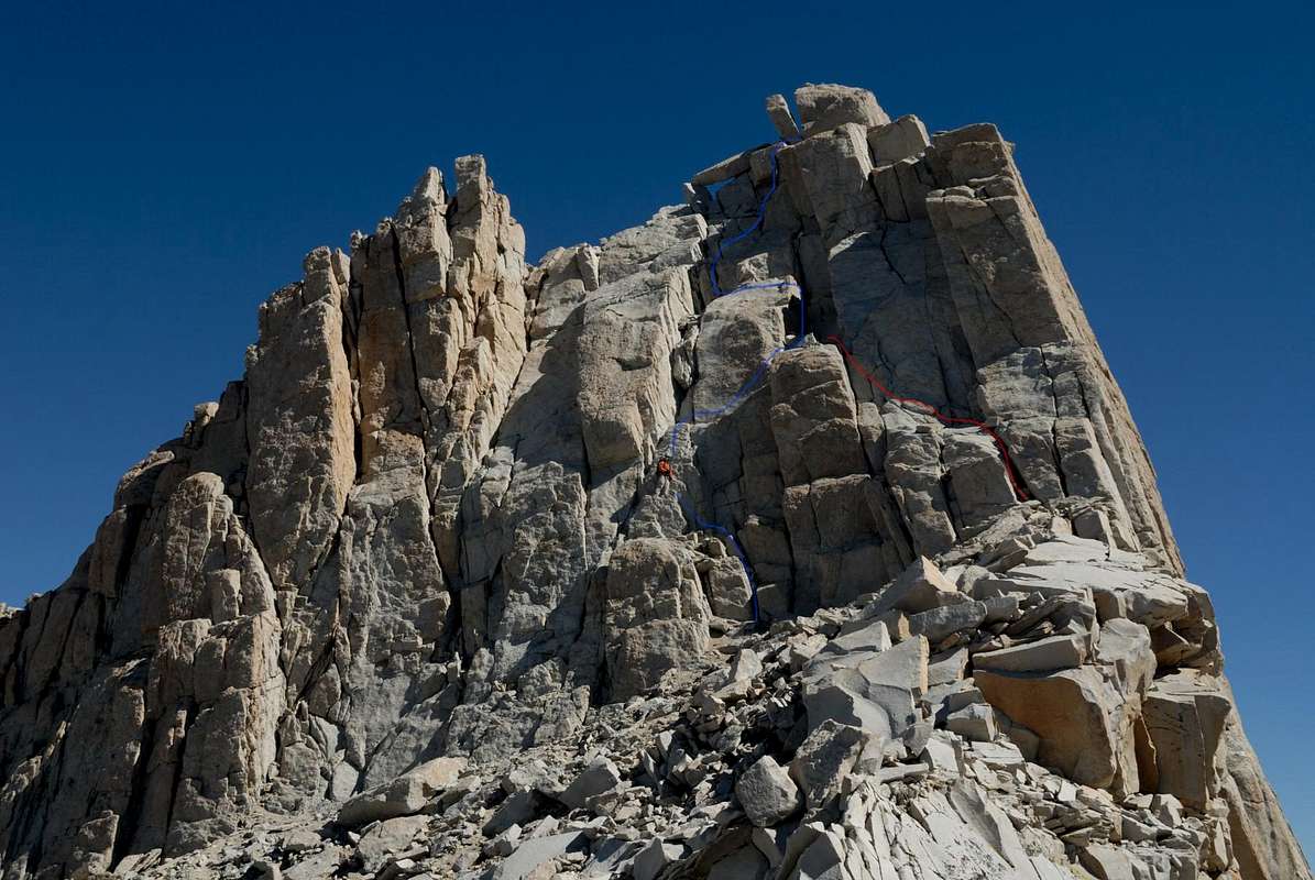
To give you an idea of Mt. Muir in case you were still considering it... http://www.summitpost.org/mount-muir/150495" onclick="window.open(this.href);return false;
Take everything including photos great caution. I've never seen routes or photos give complete and total justice to the description of a mountain and it's routes. Only you can decide for yourself how and what you're willing to do especially alone. I've been in that situation plenty of times especially this summer.
This photo though.. http://images.summitpost.org/original/364878.jpg" onclick="window.open(this.href);return false; Gives a fairly good idea of what the class 3 route entails. Looks spicy but super fun. Nothing quite like summiting a nice mountain and enjoying your last day. Be safe out there!
Never put off a backpacking trip for tomorrow, if you can do it today...
Alpine Mike-
http://mikhailkorotkinphotography.com/" onclick="window.open(this.href);return false;
Alpine Mike-
http://mikhailkorotkinphotography.com/" onclick="window.open(this.href);return false;
-
byeager
- Topix Novice
- Posts: 8
- Joined: Mon Aug 25, 2014 10:38 am
- Experience: N/A
Re: Sierra First Timer - High Sierra Trail Itinerary Advice Need
Thanks for the picture alpinemike. The topo definitely does not do it justice. If I had a partner I would go for it, but it is probably not a good idea solo, particularly considering how much descending I have in store for that afternoon.
The phone thing is partially my own fault. I was backpacking solo in Shenandoah last fall and ran into a bear (not literally but was within 50 feet or so before I spotted it in the late afternoon shadows). I called my wife to tell her about it and then proceeded to not call her for two days for lack of a cell signal. Dumb dumb dumb...
The phone thing is partially my own fault. I was backpacking solo in Shenandoah last fall and ran into a bear (not literally but was within 50 feet or so before I spotted it in the late afternoon shadows). I called my wife to tell her about it and then proceeded to not call her for two days for lack of a cell signal. Dumb dumb dumb...
Who is online
Users browsing this forum: c9h13no3, muleaaron, Noahz, skrowan and 72 guests