Hiya!
So my end goal for this year is to get back to a place I went when I was still in the scouts (about 13 years ago) Tulainyo Lake. I figure that while its technically possible to get to the lake and back in one day I am no where near in good enough shape to do it all in one day.
On Day One I want to go from the portal to Upper Boyscout Lake.
On Day Two I want to go from Upper Boyscout Lake, up and over the pass and reach Tulainyo Lake.
On Day Three Leave Tulainyo Lake and head back to the portal.
I want to do this in late july early august.
I figure that if I am going to be dealing with altitude sickness I'll know by the time I wake up at boyscout lake, so i'll know if I can continue on.
I would say that my backpacking experience has declined pretty badly from disuse. I would say that it used to be a 4... now its maybe a 2...
My terrain comfort level used to be all of the above but now its a pretty high 2.
I think that's about it, and I hope that everyone could tell me how realistic this is.
Trip Planning: Tulainyo Lake via Whitney Portal
-
AlaskaIsCold

- Topix Acquainted
- Posts: 31
- Joined: Sun May 11, 2014 1:59 pm
- Experience: Level 2 Backpacker
- Location: San Jose, CA
- Contact:
Trip Planning: Tulainyo Lake via Whitney Portal
----
Everyone has a happy place.
Mine is Tulainyo Lake at Sunset.
I do hope to make it back there one day.
Everyone has a happy place.
Mine is Tulainyo Lake at Sunset.
I do hope to make it back there one day.
-
Hobbes

- Topix Fanatic
- Posts: 1120
- Joined: Wed Apr 27, 2011 8:09 am
- Experience: N/A
- Location: The OC
Re: Trip Planning: Tulainyo Lake via Whitney Portal
Couple of points. One, that really isn't a pass, but rather a col called Russell-Carillon:AlaskaIsCold wrote:On Day Two I want to go from Upper Boyscout Lake, up and over the pass and reach Tulainyo Lake.
viewtopic.php?f=31&t=8398" onclick="window.open(this.href);return false;
Two, it's hard(er) to get a pass into the Whitney zone as opposed to simply exiting the region after entering from a different trailhead.
Three, some people (including myself) are planning on meeting up @ Wallace lake the 4th week of July (21-25). Tulainyo would be a fun day hike from Wallace (a little under 3 miles). Given the conditions and your confidence level, you might even considering exiting over R-C col at that point.
I'm entering @ Horseshoe and exiting @ Shepherd.
Edit: I should add that if you do make it over from Portal and are returning on the 25th (Friday), I might join you on the way back. I've mentioned on the meet-up threads that if anyone who has experience with R-C col is exiting that way, that I might join them. If you make it over in one-piece, then I figure that qualifies you as having experience for the return trip. {grin}
-
maverick

- Forums Moderator

- Posts: 11835
- Joined: Thu Apr 06, 2006 5:54 pm
- Experience: Level 4 Explorer
Re: Trip Planning: Tulainyo Lake via Whitney Portal
Hobbes wrote:
If you make it over in one-piece, then I figure that qualifies you as having experience for
the return trip.
Your trip is doable, but would highly recommend that you get yourself into good
backpacking shape, not only will this allow you to enjoy your trip much more, but it
will be safer. We are having our HST Meet-up, which Hobbes mentioned, you would
be very welcomed, I am planning to do some photography of the Tulainyo Lake area.
Professional Sierra Landscape Photographer
I don't give out specific route information, my belief is that it takes away from the whole adventure spirit of a trip, if you need every inch planned out, you'll have to get that from someone else.
Have a safer backcountry experience by using the HST ReConn Form 2.0, named after Larry Conn, a HST member: http://reconn.org
-
Wandering Daisy
- Topix Docent
- Posts: 6689
- Joined: Sun Jan 24, 2010 8:19 pm
- Experience: N/A
- Location: Fair Oaks CA (Sacramento area)
- Contact:
Re: Trip Planning: Tulainyo Lake via Whitney Portal
Experience level "2" is a bit sketchy for Corillion Col. Class 2 is an incredibly broad range of difficulty. Down-climbing the harder north side with a pack may be too difficult. But if you had been at much higher levels in the past, brushing up on exposed class 3 climbing with a pack, as practice before the trip, would be valuable. I find as I get older, I may be still in good shape but am less comfortable on exposed class 2-3 with my full pack (OK, I am gutless nowadays!)
I was not terribly impressed with Tulainyo Lake (poor camping and swarming with black flies when I was there) and feel Wallace and Wales Lakes are much more scenic. Personally, although longer, I would choose to go in from Shepherd Pass, over Rockwell Pass and down Wrights Creek and base camp at Wallace Lake. You could still plod up Shepherd Pass in conditions that would make Corillion Pass impossible.
I was not terribly impressed with Tulainyo Lake (poor camping and swarming with black flies when I was there) and feel Wallace and Wales Lakes are much more scenic. Personally, although longer, I would choose to go in from Shepherd Pass, over Rockwell Pass and down Wrights Creek and base camp at Wallace Lake. You could still plod up Shepherd Pass in conditions that would make Corillion Pass impossible.
-
Hobbes
- Topix Fanatic
- Posts: 1120
- Joined: Wed Apr 27, 2011 8:09 am
- Experience: N/A
- Location: The OC
Tulainyo Lake via Whitney Portal
If you leave out of Horseshoe, then for the price of a shuttle and around 8 extra miles*, you can fish, swim and/or camp along the way here:

And here:
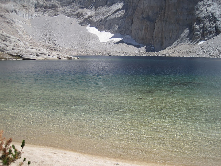
*I'm calculating 25.9 miles to get to Wallace via Miter and 17.3 miles to exit via WLB/Rockwell down to Symmes.
JimR is taking the same route a day earlier. If these images aren't enough to get people licking their lips, well, I don't know what will.
Edit: As an added bonus, if you're feeling energetic or have an extra day, you can hit Langley along the way to see Whitney:

And short cut the return down to Miter:
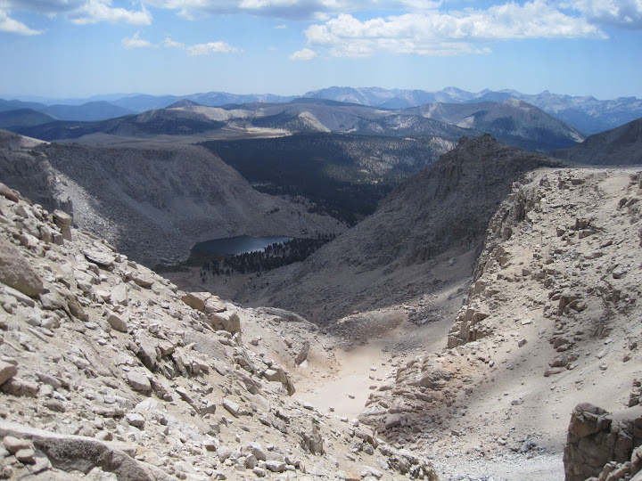
I know you NorCal peeps are thinking about this - it's the southernmost portion of the high Sierra, so it's a bit of a haul, but it's pretty cool.
And here:
*I'm calculating 25.9 miles to get to Wallace via Miter and 17.3 miles to exit via WLB/Rockwell down to Symmes.
JimR is taking the same route a day earlier. If these images aren't enough to get people licking their lips, well, I don't know what will.
Edit: As an added bonus, if you're feeling energetic or have an extra day, you can hit Langley along the way to see Whitney:
And short cut the return down to Miter:
I know you NorCal peeps are thinking about this - it's the southernmost portion of the high Sierra, so it's a bit of a haul, but it's pretty cool.
-
Ikan Mas
- Topix Regular
- Posts: 374
- Joined: Tue Nov 10, 2009 9:43 pm
- Experience: N/A
Re: Trip Planning: Tulainyo Lake via Whitney Portal
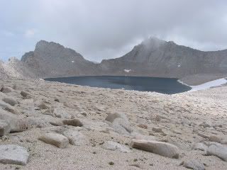
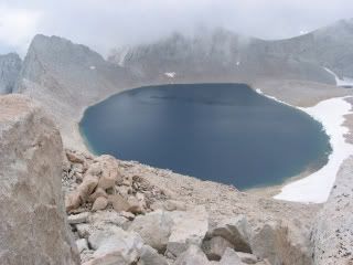
A couple of photos of the subject lake. These were taken from Tunnabora Peak in August of 2003.


Who is online
Users browsing this forum: Bing [Bot] and 232 guests