2014 Member Meet-up 7/22-7/27

A forum to initiate member meet-up. Looking for a hiking/climbing/fishing/skiing/etc. partner, or are you planning a trip where you wouldn't mind having some company? Last minute invites can be just as fun as a well-planned group trip (sometimes even better) so don't be shy! And be sure to post a trip report to the appropriate forum when you get back.
Post Reply
User avatar
Hobbes
Topix Fanatic
Posts: 1120
Joined: Wed Apr 27, 2011 8:09 am
Experience: N/A
Location: The OC

Re: 2014 Member Meet-up 7/22-7/27

Post by Hobbes »

KathyW wrote:It's pretty easy to get to Soldier Lake (the lower one) from Horseshoe Meadows in one day. The easiest route is via Cottonwood Pass. Also, if I had to pick between New Army and Army Pass, I would go over New Army Pass. Getting to Soldier Lake in the first day would give you more time to enjoy the rest of the journey, but that's just my take on things.
I agree about Cottonwood pass - I've done every pass a few times going back and forth in various loops between Miter and the PCH. Sometimes I feel like I'm slumming it, but it's such an easy point to get to from LA for a quick in & out.

The thing about Cottonwood is you either have to go all the way to Soldier or pull up short @ Chickenspring. Personally, I sort of hate Soldier (I think it's surprisingly bland), so it's no place I'd like to spend the night. Besides, if I were to leave in the morning, 9 miles is too short for me - much better to continue to SBL.

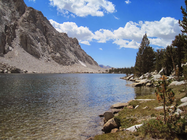
Also, CP is so flat & fast, I can avg almost 3mph, so I can get to Soldier in under 4 hours. Leave at 8am and arrive at noon to do ... what? Hang out around a grassy, shallow lake with obstructed views, poor fishing, and, did I mention, lots of people? [It's a tangent of the PCH a lot of people take vs Rock Creek + it has a bear box.] And did I mention the trees? Trees everywhere blocking the views! LOL end rant.

OTH, if one were to hit the tail in the afternoon (as I'm planning after shuttling my car), the Cottonwood lakes are much prettier and put you in position to go up and over the next day. The total gain/loss is almost a toss up between dropping down to (lower) Soldier from NAP or gaining an extra 500' from AP up Langley and then dropping down to (upper) Soldier. Again, it comes down to taste - I think the trail down from NAP is boooring, and don't like lower Soldier. Going up the Langley shoulder provides great views, and upper Soldier is much nicer IMO.

What's got me interested in this trip are four things:
- finally stitching together some last pieces of the area between Whitney and Shepherd
- fishing Wallace
- meeting some posters
- slowing down and hanging out/fishing this place (yes, that's a beach):

Image

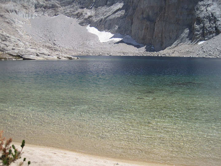
Side note: This is the lake I dream of as I'm jogging along trying to get in hiking shape. I hate jogging, but it makes it all worthwhile to make it here not completely whacked out.
Last edited by Hobbes on Fri Feb 21, 2014 11:04 am, edited 2 times in total.
User avatar
maverick
Forums Moderator
Forums Moderator
Posts: 11834
Joined: Thu Apr 06, 2006 5:54 pm
Experience: Level 4 Explorer

Re: 2014 Member Meet-up 7/22-7/27

Post by maverick »

Hobbes wrote:
What's got me interested in this trip are three things:
- finally stitching together some last pieces of the area between Whitney and Shepherd
- fishing Wallace
- slowing down and hanging out/fishing this place:
What about meeting your fellow HST members who share your enthusiasm for the
Sierra? Just joking. ;)
Thanks for posting your spreadsheet, could be useful to folks looking for alternate/easier
ways to get to Wallace. :thumbsup: It may even get SSSDave interested now that there
is a spreadsheet on it. :)
Professional Sierra Landscape Photographer

I don't give out specific route information, my belief is that it takes away from the whole adventure spirit of a trip, if you need every inch planned out, you'll have to get that from someone else.

Have a safer backcountry experience by using the HST ReConn Form 2.0, named after Larry Conn, a HST member: http://reconn.org
User avatar
Jimr
Forums Moderator
Forums Moderator
Posts: 2176
Joined: Fri Jul 31, 2009 2:14 pm
Experience: Level 4 Explorer
Location: Torrance

Re: 2014 Member Meet-up 7/22-7/27

Post by Jimr »

Here's my itinerary
http://caltopo.com/map?id=686O" onclick="window.open(this.href);return false;
Last edited by Jimr on Sat Feb 22, 2014 9:30 pm, edited 3 times in total.
If you don't know where you're going, then any path will get you there.
User avatar
maverick
Forums Moderator
Forums Moderator
Posts: 11834
Joined: Thu Apr 06, 2006 5:54 pm
Experience: Level 4 Explorer

Re: 2014 Member Meet-up 7/22-7/27

Post by maverick »

Have reserved 6 permits (one for myself and one for Claus) for the 22nd. This will
allow 4 of you who would be more comfortable hiking over Shepherd Pass with a group
and getting to Wallace Basin to do so. Please PM me if you would like one of the
4 remaining permits slots.
Professional Sierra Landscape Photographer

I don't give out specific route information, my belief is that it takes away from the whole adventure spirit of a trip, if you need every inch planned out, you'll have to get that from someone else.

Have a safer backcountry experience by using the HST ReConn Form 2.0, named after Larry Conn, a HST member: http://reconn.org
User avatar
Hobbes
Topix Fanatic
Posts: 1120
Joined: Wed Apr 27, 2011 8:09 am
Experience: N/A
Location: The OC

Re: 2014 Member Meet-up 7/22-7/27

Post by Hobbes »

Kathy W, as usual, provides a bit of sanity with regards to New Army Pass vs Army Pass. I created another spreadsheet that shows the route up NAP, which by the looks of things adds about .4 miles:

Image

For those who are unaware of the great NAP vs AP debate, there have been 2 deaths on Army Pass - as a result of falls - in the last 4 years. One occurred when there was still snow/ice on the cornice, and the other was in a fogged in rain storm (ie slippery + poor visibility). AP faces north, so snow remains well into summer, and it hasn't been maintained for over 30 years after the FS moved the main trail to NAP.

I came down AP a few years ago in Sept, and it's actually pretty straightforward when everything is "just right". However, the advantage NAP has is that it leaves all that drama behind. It such a well engineered pass that I've practically jogged up it before.

The other advantage of NAP is that you can hike to either Long or High lakes the day/afternoon before - High is only 1 mile from the pass - to get really close to the top. That cuts down the mileage for the next day:

AP - day 0 = 5.5 miles, day 1 = 11.0 miles
NAP - day 0 = 6.5 miles, day 1 = 10.4

I'm now leaning towards NAP, simply because I don't want to have any potential hiccups. I have a place in mind to reach on day 1, I've done each portion (including a trip to the top of Langley) of all these various routes before, so I want to just motor along in an attempt to experience a "perfect hike" ie no surprises, no mistakes.

And yes, Mav, I'm counting on having a fish fry with other members @ Wallace. Ole'.
User avatar
Hobbes
Topix Fanatic
Posts: 1120
Joined: Wed Apr 27, 2011 8:09 am
Experience: N/A
Location: The OC

Re: 2014 Member Meet-up 7/22-7/27

Post by Hobbes »

Jimr wrote:Here's my itinerary
I'm planning on being @ the Crabtree lakes on the 22nd as well - we should look for each other. I noticed you're planning on staying at lake #1 (I think I'll stay @ #3). Lake #1 is pretty darn nice:

Image

Either way, I'll probably see you on the trail and @ Wallace the next day. Btw, you can just walk along the edge of Crabtree mdw straight to the PCT, rather than cut over to the JMT/Whitney trail. There's a slight re-gain in elevation if you go that way - besides, that meadow is pretty bitchin' to walk along:

Image
User avatar
Jimr
Forums Moderator
Forums Moderator
Posts: 2176
Joined: Fri Jul 31, 2009 2:14 pm
Experience: Level 4 Explorer
Location: Torrance

2014 Member Meet-up 7/22-7/27

Post by Jimr »

I just logged on to make the same statement about Crabtree. My camp spot there isn't written in stone but I wanted to get a bit farther along that day. We'll see how it goes. I'm going to fish lake #3 for sure. Thanks for the 411 about bypassing JMT from there. I always prefer to be off trail when I can. I'll do some adj. on that section.

I went up and down OAP three years ago in July. I believe it was a heavy snow year in 2011 and I was worried about getting through, but I knew I could abort and move to NAP if needed. I also thought I could go up the pass the afternoon before and stomp footholds in beforehand, but then decided that was probably a lame idea. Turned out that was exactly what I did. Not only did I stomp footholds in the afternoon before, but on our return, we were talking with a couple and they asked about OAP. I told them we didn't have any trouble and they decided to give it a try. That made me nervous, so on the return, I used my big heavy Danner boots to re-stomp footholds for them. My buddy was wondering what was taking me so long and thought I was having some fear issues, so I told him I was really bummed that our conversation changed the couple's decision and I wanted to do what I could to maximize their success.

I don't think there will be any snow issues this year unless there is another March Miracle like the one in 1990 or 91 when it hardly snowed all winter, then March got 28 days of snow.
Last edited by Jimr on Sat Feb 22, 2014 9:23 pm, edited 1 time in total.
If you don't know where you're going, then any path will get you there.
User avatar
Jimr
Forums Moderator
Forums Moderator
Posts: 2176
Joined: Fri Jul 31, 2009 2:14 pm
Experience: Level 4 Explorer
Location: Torrance

Re: 2014 Member Meet-up 7/22-7/27

Post by Jimr »

Hobbes,
I added a red line and modified the blue line. Which way around Crabtree Meadow are you suggesting?
If you don't know where you're going, then any path will get you there.
User avatar
rlown
Topix Docent
Posts: 8225
Joined: Thu Oct 25, 2007 5:00 pm
Experience: Level 4 Explorer
Location: Wilton, CA

Re: 2014 Member Meet-up 7/22-7/27

Post by rlown »

I have yet to see a fish picture or actual size response anywhere on this forum about Wallace or the Wrights. If i have to hike 2 days in, it has to be a known quantity, not older than 3 years old data.. I can interpolate at that point. I don't want 20 year old data. It doesn't have to be public, but If you know.. Yes it's nice to meet people, but I go to fish; not just to hike.

russ
User avatar
DriveFly44
Topix Regular
Posts: 268
Joined: Tue Jul 15, 2008 9:33 am
Experience: Level 3 Backpacker
Location: Twain Harte

Re: 2014 Member Meet-up 7/22-7/27

Post by DriveFly44 »

rlown wrote:I have yet to see a fish picture or actual size response anywhere on this forum about Wallace or the Wrights.
Hey Russ,

Check out the last two fish pics in my JMT report. They are from WLB (upper lake next to tawny point). Not huge but pretty nice.

viewtopic.php?f=1&t=9810" onclick="window.open(this.href);return false;

Ladd
Post Reply

Who is online

Users browsing this forum: No registered users and 14 guests