If you've been searching for the best source of information and stimulating discussion related to Spring/Summer/Fall backpacking, hiking and camping in the Sierra Nevada...look no further!
urnotreal wrote:Both of these areas look incredible (really like the idea of camping at Hortense Lake).
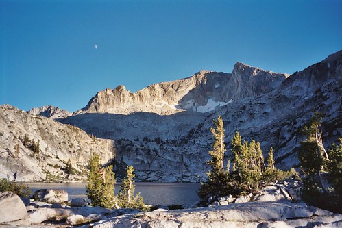
Hortense Lake is gorgeous--my favorite lake in that area.
The Kid Lakes idea is very intriguing. I was originally going to try to include it but wasn't sure given time constraints. As of now, I'm looking at 8 days from Roads End to North Lake (carrying food for 9). I suppose with some careful packing, I could get another day's worth of food in the canister. I know I wouldn't regret it. Yep, Kid Lakes is now on the itinerary!
I personally do not think Frozen Lake Pass is as bad as its reputation. I have gone up it once and down twice (without ice axe). As long as you avoid early season or high snow years (this year does not look like it will even get to "normal", let alone high snow) you do not even need to step on snow. I made it from Lakes Basin to the small lake on the north side of Mather Pass by 3PM - easily could have made it to outlet of Palisade Lake in a day. North side of Dumbell Pass is harder than it is rated. I doubt you could make it from Lakes Basin to Palisade Lakes in a day as easily as going over Frozen Lake Pass. I did the same section (Roads End to North Lake) in 9 days and got out before Noon. I did Echo Col?? instead of Snow Tongue (I did this pass previously and really did not like it). Camped at Goethe Lake night of Day 8. I rarely hike past 3-4 PM so it really was not that difficult -and I am an old lady! But I did make it past Grouse Lake (next valley over) on the first day. Got to Grouse Lake 1PM. Started from Roads End at 5:30 AM. It was nice and cool all the way up with that early start. The trail is one of the best graded trails I have been on- a little boring but you can make really good time.
Thanks for the encouragement WD. Roper makes that first day seem like a death march.
Coming from sea level with a full pack is always hard now it seems doable to at least get to grouse lake on day one
I agree that the Copper Creek trail from Roads End is very easy to do even though it has so much gain. An early start is a must though or you will be hurting from the heat.
Water up at Upper Tent Meadow because it's pretty much the last source of water before your close to Grouse Lake.
IMO the SHR is much more enjoyable, as well as easier and safer, if your pack weight is light ( say, less than 30lb with bear canister on Day 1 of 7). For an August trip in a lower than normal snow pack year, a light pack makes the difficult passes merely strenuous. For most people comfortable on class 3 terrain there is no reason to avoid Frozen Lake Pass or Snow Tongue Pass, although a heavy pack can make class 3 seem like class 4. Traveling from Roads End to North Lake is going to involve carrying a lot of food and will increase pack weight. The first leg of the SHR has a lot of up and down and when you get to Dusy Basin you may wish you had planned to resupply via Bishop Pass.
Dogs that can do class 2 talus, and lots of it, should be able to to get from Piute to Reds.
So I've now secured 6 weeks off of work so I have a lot of room to play. For logistics reasons (and a good warm-up), I'll be starting at Onion Valley. I was originally thinking of starting light and picking up a package in Cedar Grove, but now, skipping that and resupplying in South Lake makes more sense as it will make it easier to take my time exploring Kid Lakes and Dumbell/Amphitheater basins along the way (I'm still not sure whether to run Dumbell>Cataract Creek>Upper Basin Crossing or Dumbell>north to Lake 10,565>down to Palisade Creek). Also, by making South Lake>North Lake its own leg, I'll be able to take a few days to check out Ionian Basin as well.
As for time on the trail, I'm in agreement with you, Wandering Daisy. Arriving at camp by 3-4 is ideal. I'm not afraid of a long day here and there, but I prefer to find a spot, set it up, then spend a few hours exploring/fishing/photographing the area to get a real feel for the environment into which I've immersed myself. It is home after all, even if only for a night or two.
I appreciate the suggestion on including a southern section. I've been completely ignoring that area (research wise) up until now. A quick look at the links has definitely gotten me interested, though. These are areas that need to be seen, if not this summer, then sometime in the future.
A little late to the party.... I've been looking at older threads for info on the leg of the SHR from Thousand Island Lake to TM, which we're planning to do in late July. All these suggestions are great. I'm hoping to go over "Foerster Ridge" (Secor) into the upper part of Lyell Fork. I was there decades ago and a return is on my bucket list.
Regarding the Ionian Basin, definitely do a search on this site. We went through there last year and others have trip reports from there. I also posted some info on Black Giant Pass and Wanda Pass. Neither are easy, but they are very doable. You sound like you're capable and able to manage the Ionian Basin, which is a serious endeavor. Skipping Muir Pass to get in that basin is a worthwhile trade IMHO.
So, we're planning to do some of this part of the SHR in late July:
1) TM up Lyell Canyon to "Lyell Base Camp"
2) Over Donahue and Island Pass; try to get to Lake Catherine
3) Up Ritter (bucket list item) - to Twin Island Lakes if possible
4) To Blue Lake
5) Over Blue Lake Pass then either take the Isberg Pass Trail and head east up into the Lyell Fork basin or go over "Foerster Ridge" into the Lyell Fork basin (bucket list item)
6) To Lewis Creek
7) Over Vogelsang Pass to Tuolumne Meadows
Any advice? We figure this will be challenging but less rigorous than our trek last year (South Lake to North Lake with swings through the Ionian Basin Davis Lakes Basin and heading out over Lamarck Col). But I'm still a bit concerned with the XC after Lake Catherine.
Any information on a direct route from Blue Lake/Blue Lake Pass to the upper part of the Lyell Fork would be very much appreciated!
The XC past Catherine can be tricky, but that's the fun of it. Stay right following weaknesses as you work your way down from the basin below Catherine to Twin Island; cliffs to the left!
TI to Bench- there is pretty much only one weakness into Bench. Turn the corner at about 10,300.
As far as crossing directly over the "Merced Range" into the Lyell Fk, I have done that thru a small notch just east of Mt Ansel Adams via the north fork Bench Canyon. This was on skis so I'm not sure how it would be in summer; it is a steep chute on the north side. Other than Blue Lake Col there is Harriet Pass which is my favorite way across, very scenic.
Foerster ridge is best passed up high next to the peak at ~11,240. Been over that thing four times now and the only problem I've had is dropping off a 10' cornice on the north side (shouldn't be a problem in summer).
I don't think it's all that much more difficult than the Ionian/Davis loop, just a couple of places you need to hit right.