Lamarck Col west-to-east?
-
mokelumnekid

- Topix Expert
- Posts: 475
- Joined: Mon Sep 22, 2008 4:45 pm
- Experience: N/A
- Location: Seattle
- Contact:
Lamarck Col west-to-east?
Hey gang, I've been over the col plenty but never west-to-east. The route is obvious going east-to-west, but I'm guessing less so going the other way. Is there anything I need to keep in mind when starting up from Darwin Bench/Canyon, so that I pretty much hit the correct notch? Thanks!
-
cgundersen

- Topix Fanatic
- Posts: 1338
- Joined: Sun Jul 16, 2006 1:07 pm
- Experience: N/A
Re: Lamarck Col west-to-east?
Hi Mk,
I've run into folks who had problems, but on my last time over (3 years ago) there was even a bit of a use trail near the low point on the ridge. I've always followed pretty much the line east from the last lake and when you hit a modest plateau a couple hundred ft up you veer left (north) and pretty much aim for the low spot on the ridge. On my last time there, my 2 companions ascended slightly different routes than I did, and the climbs seemed pretty comparable in terms of the amount of boulder hopping versus short sandy/gravel pitches. The usual drill followed by those sensational views that you'll be leaving behind............
cg
-
Jimr

- Forums Moderator

- Posts: 2176
- Joined: Fri Jul 31, 2009 2:14 pm
- Experience: Level 4 Explorer
- Location: Torrance
Re: Lamarck Col west-to-east?
As cg mentioned, it is NE of the highest lake. The notch directly east that looks like it should be it, actually puts you into Sabrina basin. It's the ridge to the left. On the right side of the ridge, there's a small notch, really small. You'll start seeing ducks here and there.
Although there are far too many small ducks, the larger ducks line up with each other. Keep you eye out for the larger ducks, then align them looking down, then turn straight up. You will have a hard time doing this looking uphill, but when you hit one, look down from it and you will see more and more of them in a line down hill and can use that to keep on the mark.
i know I have a pic at work. I'll attach it Monday unless somebody beats me to it.
If you don't know where you're going, then any path will get you there.
-
giantbrookie

- Founding Member & Forums Moderator
- Posts: 3582
- Joined: Wed Dec 28, 2005 10:22 am
- Experience: N/A
- Location: Fresno
- Contact:
Re: Lamarck Col west-to-east?
As noted above, the key is that Lamarck Col is not the lowest point on the ridge east and north of Darwin Cyn. There is a pretty good web of use trails that head to the correct saddle, though, from Darwin Cyn. If you look at the topo you can see that the optimal ascent route peels off from the Darwin Cyn floor between highest and second highest lake and ascends the shoulder that drops to the canyon bottom between these lakes. Once atop that one is in the axis of a swale that leads directly NNE to Lamarck Col. Lamarck Col is the first saddle SE of Mt. Lamarck. If you start ascending NNE from between the two highest lakes it is unlikely you'll head for the lowest point on the ridge (further E) because some very serious and counterintuitive sidehilling would be necessary to do this. The only possible error one could make is to head for the next saddle S of Lamarck Col, but this also involves a bit of sidehilling or, at best a diagonal traverse against the fall line. Given the web of use trails and the topography, if you take off between the two highest lakes you'll pretty much be led to Lamarck Col. If for some reason you miss by one notch (and you'll know this by what you'll see on the other side) it is really easy class 2 to head north to the correct saddle.
Since my fishing (etc.) website is still down, you can be distracted by geology stuff at: http://www.fresnostate.edu/csm/ees/facu ... ayshi.html" onclick="window.open(this.href);return false;
-
maverick

- Forums Moderator
- Posts: 11834
- Joined: Thu Apr 06, 2006 5:54 pm
- Experience: Level 4 Explorer
Re: Lamarck Col west-to-east?
Have nothing to add in the way of a route description that hasn't already
been said by members except that Kathy's pictures with her descriptions may
help too.
http://kathywing.smugmug.com/California ... &k=fsSNpH5" onclick="window.open(this.href);return false;
been said by members except that Kathy's pictures with her descriptions may
help too.
http://kathywing.smugmug.com/California ... &k=fsSNpH5" onclick="window.open(this.href);return false;
Professional Sierra Landscape Photographer
I don't give out specific route information, my belief is that it takes away from the whole adventure spirit of a trip, if you need every inch planned out, you'll have to get that from someone else.
Have a safer backcountry experience by using the HST ReConn Form 2.0, named after Larry Conn, a HST member: http://reconn.org
-
quentinc
- Topix Expert
- Posts: 890
- Joined: Tue Nov 01, 2005 10:28 pm
- Experience: N/A
- Location: Los Angeles
Re: Lamarck Col west-to-east?
Quite a good use trail has been constructed in recent years. It takes you further east/northeast (to the right of the col) than you would naturally think to head. The use trail is particularly helpful near the top, since otherwise you have to pull yourself up over boulders.
There are ducks. But there are always ducks, and leading in a million different directions. Hikers should be required to pass a test before being allowed to build ducks anywhere in the backcountry.
There are ducks. But there are always ducks, and leading in a million different directions. Hikers should be required to pass a test before being allowed to build ducks anywhere in the backcountry.
-
Jimr
- Forums Moderator
- Posts: 2176
- Joined: Fri Jul 31, 2009 2:14 pm
- Experience: Level 4 Explorer
- Location: Torrance
Re: Lamarck Col west-to-east?
"Hikers should be required to pass a test before being allowed to build ducks anywhere in the backcountry."
I second that! There should also be a section on when and what ducks to dismantle. The Sierra is a veritable duck pond.
I second that! There should also be a section on when and what ducks to dismantle. The Sierra is a veritable duck pond.
If you don't know where you're going, then any path will get you there.
-
ManOfTooManySports
- Topix Regular
- Posts: 142
- Joined: Thu Jul 14, 2011 3:58 pm
- Experience: N/A
Re: Lamarck Col west-to-east?
We went W to E on Saturday...and got off track. Ranger Dave suggested we go up fro the last large lake in Darwin Canyon. This worked out fine. Where we got off base was after following the use trail, it simply ended on a bench. There are ducks here and there, and we followed the one to the left into sand and talus. Wrong! Ranger Susan was 30' behind us and she stayed closer to the hard-rock ridge that runs to the right of the line toward the col. There is some deep green meadow in there, which you can use as a marker. From above this was clearly the way to go. So, if all else fails, bear right.
When you get within a few hundred vertical feet of the top, the definitiveness of the trails peter out. Keep your eyes and suffer through that. Again, bearing right is probably better than bearing left. Eventually you'll pick up more defined trails. Near the top, the parks and forest service have built honest to gosh trails that are easy to follow.
When you get within a few hundred vertical feet of the top, the definitiveness of the trails peter out. Keep your eyes and suffer through that. Again, bearing right is probably better than bearing left. Eventually you'll pick up more defined trails. Near the top, the parks and forest service have built honest to gosh trails that are easy to follow.
-
Jimr
- Forums Moderator
- Posts: 2176
- Joined: Fri Jul 31, 2009 2:14 pm
- Experience: Level 4 Explorer
- Location: Torrance
Re: Lamarck Col west-to-east?
I just realized that nobody has mentioned this yet. It really helps to get out the map and compass and triangulate a few reference points to orient yourself with the features on the ridge and get a mental picture of what is on the other side, then take some bearings to help identify the col. Once you have the general spot, how to get there becomes more straight forward.
Although, in the mountains, God used crooked lines to make straight paths
Although, in the mountains, God used crooked lines to make straight paths
If you don't know where you're going, then any path will get you there.
-
SSSdave
- Topix Addict
- Posts: 3524
- Joined: Thu Nov 17, 2005 11:18 pm
- Experience: N/A
- Location: Silicon Valley
- Contact:
Re: Lamarck Col west-to-east?
Jimr last post opening up the map and compass was good advice. I really wish more of you would regularly open up links to topo maps like acme when offering verbal directions because the results are otherwise often vague and or ambiguous to other parties. Of course where to cross Lamarck Col constantly comes up on boards year after year, even with those like you that have previously crossed it.
http://mapper.acme.com/?ll=37.18627,-118.67410&z=15&t=T" onclick="window.open(this.href);return false;
Mokid ought to open up Google Earth and become familiar with that landscape. From Lake 11623, looking at the topo, one will note just south of Lamarck Col, 12920+, a peaklet intersection, 13,080+ of the Sierra Crest with the sub ridge of point 13172. Viewed even from the outlet of lake 11592, that peaklet is barely noticeable. As one moves closer up the pater noster lake chain, that peaklet is even less noticeable, especially while climbing the direct slope west. One will also note the low point on the Sierra Crest is lower at 12600+. From the bottom of the direct west slope, one cannot discern an obvious low point because one is much too close as the ridge tops tower above.
Do not at all expect to follow ducks or use trails including ones that appear most used because they are all over the place including those leading to the low point that looks down on Schober Lakes. Climbers sometimes climb up the class 2/3 talus to reach Darwin and Mendel via that route so there is a use trail on the sandy west slopes.
At the col, there actually is a Kings Canyon National Park sign and real trail for a few hundred feet down from the very top of the west side. But if one does not pass through notch #2, one will miss that. With compass, from, Darwin Canyon Lake #4 inlet one can measure on the topo that the col is 45 degrees south from due north. So by reaching lake #4, the best strategy if not familiar is as Jimr noted, take out your map and compass. Also if advancing east along the lake chain, one can note the mentioned 13,080 peaklet and keep one's eye out along the way to where one needs to climb towards once reaching the base. The most used route above lake #4 follows the shallow ravine at the first "n" in Canyon of the topo.
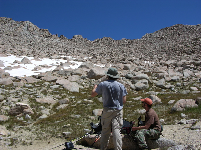
There are four minor notches in the ridgeline at the col and although one could pass through any of them, the second from the south is where the park sign and trail are and where one ought aim at. However coming up from below one will not be able to discern the notches. Note GE 3D will offer no clarity. There are tons of web images from the east side but few useful from the west. This image shows the col from about 11.8k on the west slope.
http://www.lebofsky.com/pictures/sierra06/images/77.jpg" onclick="window.open(this.href);return false;
The second notch is directly above the right shoulder of the guy in the grey t-shirt. The easiest way up once reaching 11.8k towards that route is not to climb directly towards it but rather curve around some further south in order to reach a sandy ramp that turns back north at 12240 feet where the township number 2 shows. Otherwise one will have to navigate through a small bowl of larger talus that is also somewhat snowy late into most summers.
http://mapper.acme.com/?ll=37.18627,-118.67410&z=15&t=T" onclick="window.open(this.href);return false;
Mokid ought to open up Google Earth and become familiar with that landscape. From Lake 11623, looking at the topo, one will note just south of Lamarck Col, 12920+, a peaklet intersection, 13,080+ of the Sierra Crest with the sub ridge of point 13172. Viewed even from the outlet of lake 11592, that peaklet is barely noticeable. As one moves closer up the pater noster lake chain, that peaklet is even less noticeable, especially while climbing the direct slope west. One will also note the low point on the Sierra Crest is lower at 12600+. From the bottom of the direct west slope, one cannot discern an obvious low point because one is much too close as the ridge tops tower above.
Do not at all expect to follow ducks or use trails including ones that appear most used because they are all over the place including those leading to the low point that looks down on Schober Lakes. Climbers sometimes climb up the class 2/3 talus to reach Darwin and Mendel via that route so there is a use trail on the sandy west slopes.
At the col, there actually is a Kings Canyon National Park sign and real trail for a few hundred feet down from the very top of the west side. But if one does not pass through notch #2, one will miss that. With compass, from, Darwin Canyon Lake #4 inlet one can measure on the topo that the col is 45 degrees south from due north. So by reaching lake #4, the best strategy if not familiar is as Jimr noted, take out your map and compass. Also if advancing east along the lake chain, one can note the mentioned 13,080 peaklet and keep one's eye out along the way to where one needs to climb towards once reaching the base. The most used route above lake #4 follows the shallow ravine at the first "n" in Canyon of the topo.
There are four minor notches in the ridgeline at the col and although one could pass through any of them, the second from the south is where the park sign and trail are and where one ought aim at. However coming up from below one will not be able to discern the notches. Note GE 3D will offer no clarity. There are tons of web images from the east side but few useful from the west. This image shows the col from about 11.8k on the west slope.
http://www.lebofsky.com/pictures/sierra06/images/77.jpg" onclick="window.open(this.href);return false;
The second notch is directly above the right shoulder of the guy in the grey t-shirt. The easiest way up once reaching 11.8k towards that route is not to climb directly towards it but rather curve around some further south in order to reach a sandy ramp that turns back north at 12240 feet where the township number 2 shows. Otherwise one will have to navigate through a small bowl of larger talus that is also somewhat snowy late into most summers.
Who is online
Users browsing this forum: No registered users and 56 guests