It is possible that either we could meet up at Red Devil or down at Washburn
as the dates get finalized let me know. Thanks
PS A HST backcountry get together would be really cool.
Obelisk Lake Route Questions
-
maverick

- Forums Moderator

- Posts: 11835
- Joined: Thu Apr 06, 2006 5:54 pm
- Experience: Level 4 Explorer
-
oldranger

- Topix Addict
- Posts: 2861
- Joined: Fri Jan 19, 2007 9:18 pm
- Experience: N/A
- Location: Bend, Oregon
Re: Obelisk Lake Route Questions
Wow this is getting really interesting. I think maverick should be included only if he can take some photos of the participants that enhance their appearance to rank with his fine landscape photos! 
Gee if the Yosemite NPS picks up on this we might be setting ourselves up for a backcountry Stoneman Meadow Massacre. (TT you might be a little young to remember, lol).
Mav--My projected starting date is about the 16th of July from Granite Creek then to Long Creek, Bench Canyon/Blue Lakes, Harriet Lakes, Merced Peak fork just below the Red Peak Pass Trail meet up with Mark and Tom somewhere around here. As Mark said we will firm up our meeting location in June. Mark (I assume) and I will gladly trade some fish for a photo or two that makes us look really good! Tom has volunteered to carry much of our load for some fish so a photo or two would be more than fair .
.
Setting up for a great summer.
Mike
Gee if the Yosemite NPS picks up on this we might be setting ourselves up for a backcountry Stoneman Meadow Massacre. (TT you might be a little young to remember, lol).
Mav--My projected starting date is about the 16th of July from Granite Creek then to Long Creek, Bench Canyon/Blue Lakes, Harriet Lakes, Merced Peak fork just below the Red Peak Pass Trail meet up with Mark and Tom somewhere around here. As Mark said we will firm up our meeting location in June. Mark (I assume) and I will gladly trade some fish for a photo or two that makes us look really good! Tom has volunteered to carry much of our load for some fish so a photo or two would be more than fair
Setting up for a great summer.
Mike
Mike
Who can't do everything he used to and what he can do takes a hell of a lot longer!
Who can't do everything he used to and what he can do takes a hell of a lot longer!
-
markskor

- Founding Member - RIP
- Posts: 2442
- Joined: Fri Oct 28, 2005 5:41 pm
- Experience: Level 4 Explorer
- Location: Crowley Lake and Tuolumne Meadows
Re: Obelisk Lake Route Questions
"We might be setting ourselves up for a backcountry Stoneman Meadow Massacre."
Dating myself here...I was actually there/partook in this debacle ...Vividly still recall this - it happened on July 3rd, 1970.
Cannot believe it was almost 40 years ago...chronicled in one of my stories. (Search: The Flat Straw Hats...at Stoneman Meadow)
Mark
Dating myself here...I was actually there/partook in this debacle
Cannot believe it was almost 40 years ago...chronicled in one of my stories. (Search: The Flat Straw Hats...at Stoneman Meadow)
Mark
Mountainman who swims with trout
-
maverick
- Forums Moderator
- Posts: 11835
- Joined: Thu Apr 06, 2006 5:54 pm
- Experience: Level 4 Explorer
Re: Obelisk Lake Route Questions
I like your route OR it is a similar route I attempted 3-4 years ago but was stopped
at Blue Lake Pass because of the amount of snow(some time in June), and one of the
approaches I am also considering to visit the Lyell Fork this time around.
My other route would be out of Glacier which is why I could meet up with you at
Red Devil or Washburn.
Photo's will be on the house!
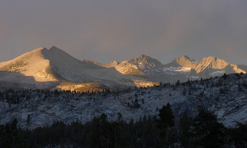
Here is a Southern view from the top of Blue Canyon Ridge to wet your appetite OR.
http://maverick.zenfolio.com/img/v7/p259283821-5.jpg" onclick="window.open(this.href);return false;
at Blue Lake Pass because of the amount of snow(some time in June), and one of the
approaches I am also considering to visit the Lyell Fork this time around.
My other route would be out of Glacier which is why I could meet up with you at
Red Devil or Washburn.
Photo's will be on the house!
Here is a Southern view from the top of Blue Canyon Ridge to wet your appetite OR.
http://maverick.zenfolio.com/img/v7/p259283821-5.jpg" onclick="window.open(this.href);return false;
-
oldranger
- Topix Addict
- Posts: 2861
- Joined: Fri Jan 19, 2007 9:18 pm
- Experience: N/A
- Location: Bend, Oregon
Re: Obelisk Lake Route Questions
maverick,
Thanks for the photo. It is amazing how much the mind forgets over 40 years! I assume that is a view down long creek. I've been up it once and down it once and don't remember it being that rough. First time was down it after hiking up Bench Canyon with my dad in the early 60s. Second time was 69 with my ex on a trip that ended in Yosemite Valley. Everytime I took her on a trip she said "I'll never go there again." So I had to keep taking her to different places. Now my true love refuses to go if I plan cross country trips. So I have to sneak cross country up on her or go with the kids or solo.
hope we cross paths
Mike
Mike
Who can't do everything he used to and what he can do takes a hell of a lot longer!
Who can't do everything he used to and what he can do takes a hell of a lot longer!
-
TehipiteTom

- Founding Member
- Posts: 953
- Joined: Thu Aug 24, 2006 8:42 am
- Experience: Level 4 Explorer
Re: Obelisk Lake Route Questions
Maverick, I hope it works out--it would be great to meet you!
-
TehipiteTom
- Founding Member
- Posts: 953
- Joined: Thu Aug 24, 2006 8:42 am
- Experience: Level 4 Explorer
Re: Obelisk Lake Route Questions
Well, we did it: we actually met up where and when we planned to! Spent the next couple days exploring some out-of-the-way corners of Yosemite. Great trip, great company. More later; for now, I'll leave y'all with a shot from near the outlet of Adair Lake after a late afternoon thunderstorm.markskor wrote:Just got a PM from this perky youngster...named Tehipite Tom…still wet behind the ears it seems. Anyway, the way it now looks is that all three of us (myself, OldRanger, and TT), are planning joining forces for what promises to be an epic summer journey. The Adair, Obelisk X-country route…meeting up mid July, 15 miles in, at Red Devil, Etna, or someplace close to… with 6 other lakes thrown in for good measure …figure 10 – 13 days of fishing. Who knows where we will eventually end up, or what damage we three can do to Yosemite.
Best part is that TT volunteered to carry all the heavy gear, as he brags about his being so much younger. Watch out Sierra, here we come.
Mark
Edit: by the way, I did do the Obelisk-to-trail route shown in the original post in this thread...made a couple of bad choices along the way, but on the whole it worked out really well.
-
norcalhiker
- Founding Member
- Posts: 58
- Joined: Sat Oct 29, 2005 7:59 pm
- Experience: N/A
- Location: Sacramento, CA
Re: Obelisk Lake Route Questions
Tom, which Obelisk to trail route did you end up doing? The third one? Slab? Cavalry?
I'm actually toying with the idea of heading up there this weekend from Happy Isles.. In January
I'm actually toying with the idea of heading up there this weekend from Happy Isles.. In January
-
oldranger
- Topix Addict
- Posts: 2861
- Joined: Fri Jan 19, 2007 9:18 pm
- Experience: N/A
- Location: Bend, Oregon
Re: Obelisk Lake Route Questions
NCH
Tom can describe his route, markskor and I followed the drainage down to the steep cascade then skirted n. and worked our way down various user/deer trails, and through brush and across slabs. A couple of hundred feet from the bottom we realized we were on the now brush covered cavalry trail (a clearly constructed trail with switchbacks). We lost it at the very bottom. Obelisk, though beautiful, is one place I will not return to (no fish!).
Mike
Mike
Who can't do everything he used to and what he can do takes a hell of a lot longer!
Who can't do everything he used to and what he can do takes a hell of a lot longer!
-
markskor
- Founding Member - RIP
- Posts: 2442
- Joined: Fri Oct 28, 2005 5:41 pm
- Experience: Level 4 Explorer
- Location: Crowley Lake and Tuolumne Meadows
Re: Obelisk Lake Route Questions
Drew up our successful route on the HST Map...
Look under "Trails not maintained"
Red Devil drainage in dark blue/purple.
FYI, tried this lake twice. Once up from Merced Lake and got cliffed out - picked wrong canyon - sigh,
and once down from Red Devil with the boys (TT and OldRanger) - one hellaciously great trip - we all made it to Obelisk too, split off there - Tom went one way and Mike and I another, but,
The last few miles down to Merced River consisted, as Mike said, solid Manzanita walls and very steep.
Alas after 2 years of planning, (FYI, this route was featured in BackPacker mag - "Old Calvary Trail... supposedly stocked a century before...bla, bla, bla") there was no visible trail found, and there were no fish seen in Obelisk.
Mark
Mountainman who swims with trout
Who is online
Users browsing this forum: Bing [Bot] and 230 guests