
August 14-20
Call us the old ladies climbing club- seniors with grandchildren and creaky knees. We all wanted to climb Mt. Francis Faraquhar and North Guard and my additional objective was to camp at Big Brewer Lake to photograph the alpenglow. We had done technical climbing together in the past and decided not to take any climbing gear and just get as far as we could on “guts alone”. We all love being in the mountains whether we make the summit or not. Our main objective is to get back home safely!
I drove down a day early to get the permit, due to the stupid rule of not being able to pick up permits after 3PM. Sunday, my friends from southern California arrived at our designated meeting time and headed up the trail in 85-degree heat. After 3.5 miles and 1,250 feet elevation gain we dripped with sweat when we arrived at the designated campsite on Bubbs Creek. First order of business was to jump in the creek; then we were chased into our tents by pesky mosquitoes. Another group was camped near us, so I put ear plugs in for a peaceful night’s rest.
Day 2 we were up at dawn to get up the Sphinx Trail early to beat the heat. It was a pleasant cool, breezy and shady walk up the numerous switchbacks. Unfortunately, we failed to find the proper starting point of the supposed “use trail” on the east side of the creek and ended up doing some serious bushwhacking for a while before we got up out of the riparian jungle of Sphinx Creek. We reached the lower Sphinx Lake just in time for lunch. Unfortunately the mosquitoes decided to also have lunch on our blood so this break was short! We had now found a fairly well defined use-trail and continued upward to the second lake. Neither of the lower lakes had any appeal to us. The use-trail then ended and we got a bit too far north onto some talus, reaching Lake 10,514 mid afternoon and set up at an established campsite near the outlet. Soon I was bored so did a loop hike to the upper lakes. It looked like we had the entire basin to ourselves. Including this little afternoon hike, I had done 7 miles and about 5,000 feet of elevation gain. It was by far our hardest day of the trip. As the day ended, I watched the lake come alive with fish jumping and kicked myself for not bringing my fishing gear.

Camp

Upper basin towards Sphinx Col

Sunset at our camp
Day 3 we were hot to start climbing. We headed up to Mt. Francis Faraquhar ascending a broad chute that progressively got more difficult and exposed. This supposedly “3rd class” climb became what we all agreed closer to “4th class”. It certainly was not something we wanted to continue on with our clunky hiking shoes. Had we brought rock shoes we may have continued but about three quarters of the way up we bailed. Back at camp early afternoon we decided to move camp up to Lake 10,962 to position ourselves better for the next day’s climb of North Guard. After setting up and taking a nice cool bath, I decided to hike back to the lakes under Mt. Francis Faraquhar to get some sunset photographs. All in all, this day was a bit over 4 miles and about 4,000 feet elevation gain.

View on climb

Upper basin towards Mt Francis Faraquhar

Sunset near our camp at upper lake
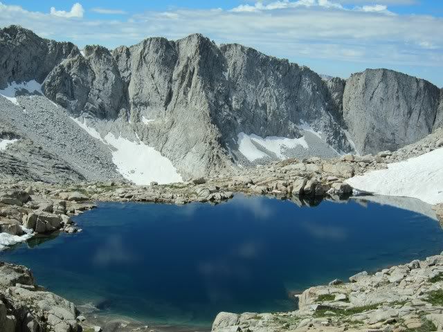
Day 4 our goal was to climb North Guard. My friends would go back to camp at Lake 10,962 and I would haul my pack over Sphinx Col and after the climb, head down to Big Brewer Lake to camp. Hard as I tried, I could not convince them to join me at Big Brewer Lake. We again awoke at dawn and started up to Sphinx Col. It was basically snow-free except for the top snowfield which was low angle and full of handy sun-cups to walk up. The snow actually made the pass easier. We then descended a bit, contoured around a buttress and intersected the creek that flows into the Brewer Basin meadow. Here I left my pack and we started climbing the south face of North Guard. I just hate it when the guidebook says “second gully” when I see three or four gullies! We think we were on the proper gully, but when we hit the ridge, it again was getting more than we wanted to do and looked quite ugly to continue. The worry is not getting up, but rather getting down! Without ropes, you have to be very careful not to climb up anything that you cannot descend! Back at my pack, I parted with my friends and slowly dropped down to Big Brewer Lake. Surprisingly, mosquitoes were few, even in the meadow that is designated as a “swamp” on the map. I took a bath then found a nice campsite, perched on a rock, with a perfect view for the evening sunset. The sunset and alpenglow did not disappoint! It was as spectacular as billed. Again I watched tons of fish jump and regretted having no fishing gear. Murphy’s Law of fishing- if you bring gear there are no fish; if you do not bring gear, there are sure to be fish! All in all, I had done about 4.5 miles and 2,300 feet elevation gain. I had the entire Brewer Basin to myself, and was really enjoying the solitude.

Climb to ridge of North Guard

Flowers in Brewer Basin


Progression of sunset at Big Brewer Lake
Day 5 I packed up regretting that I had to leave this magic place and hiked back up to the “swamp” where I dropped my pack and headed up to Cinder Col to get a view of South Guard Lake. Agreeing to meet my friends at 1PM, I did not have time to drop down to the lake. I descended to my pack and then headed for Sphinx Col reaching the top by 11AM. On the descent, this time I was a bit closer to the drainage center and ended up in a hillside thick with flowers. I hated to take each step as my foot crushed these delicate beauties. I was so absorbed in the field of flowers that not paying attention to the route, I ended up in a difficult section of huge talus. Back at Lake 10,962 I meet my friends and we moved camp back to Lake 10,514. For the first time of the trip, we all just sat around and chatted, having not all been together for over five years. The climbs had taken a toll on my friend’s knees. They spent the morning just resting. My day ended after 5 miles of walking and less than 2,000 feet gain. However, it was the accumulated 8,000 feet of downhill hiking that was making our old knees hurt.

Big Brewer Lake in morning (lake inlet)

Cinder Col
Lake below (south of )Sphinx Col

Alpine Flowers
Day 6, we slowly descended back to our camp on Bubbs Creek, meeting several groups on the trail who were heading to Sphinx Lakes. A few looked like they had no idea of what they were getting into! One fellow had open toe shoes! We were glad that when we were there, we had the entire lakes to ourselves. Another 5,000 feet of downhill over the giant sized steps on the trail did not do our old knees any good. Although we had plenty of time to walk all the way out, we had enough and camped early. This time we found another better established campsite. That afternoon tons of people walked by down the Bubbs Creek trail. After days with no others in sight we felt like we were on a major highway!

Bubbs Creek trail
The next morning we got up early and walked back to our cars. An entire college track team was doing the morning run up the trail as we were going down. Then half-way down, the team again passed us going down. All we thought was that those young knees were taking a beating that would catch up with them in 40 years! We said farewells and parted, them driving south and me driving north. We had obtained our most important objectives: be in the wilderness, enjoy each other’s company and come back safely.


