Tehipite Valley info?
-
bcrowell

- Topix Acquainted
- Posts: 49
- Joined: Fri Jun 18, 2010 7:35 pm
- Experience: N/A
Tehipite Valley info?
Can anyone point me to any online info about Tehipite Valley? Wikipedia and googling haven't turned up much that seems useful.
-
maverick

- Forums Moderator

- Posts: 11834
- Joined: Thu Apr 06, 2006 5:54 pm
- Experience: Level 4 Explorer
Re: Tehipite Valley info?
What is it specifically that you would like to know about TV?
Maybe I or others who have been there can help.
Maybe I or others who have been there can help.
-
bcrowell
- Topix Acquainted
- Posts: 49
- Joined: Fri Jun 18, 2010 7:35 pm
- Experience: N/A
Re: Tehipite Valley info?
To start with, where it is...?maverick wrote:What is it specifically that you would like to know about TV?
Maybe I or others who have been there can help.
-
TehipiteTom
- Founding Member
- Posts: 953
- Joined: Thu Aug 24, 2006 8:42 am
- Experience: Level 4 Explorer
Re: Tehipite Valley info?
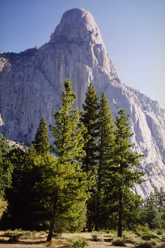
Right here. Kings Canyon National Park, 18 miles in from the nearest trailhead (Rancheria). (The last stretch is a doozy, dropping 3700' in 3 miles down switchbacks so steep you wonder why they even bothered with switchbacks at all, with a lot of loose rock on the lower portion and tons of poison oak at the bottom.) Amazing place--like being able to see Yosemite before the roads were built.
-
bcrowell
- Topix Acquainted
- Posts: 49
- Joined: Fri Jun 18, 2010 7:35 pm
- Experience: N/A
Re: Tehipite Valley info?
Thanks, that helped. So it looks like the valley itself is on the Tehipite Dome 7.5-minute quad, and the nearby trailheads are south of Wishon Reservoir, on the Rough Spur quad. Found some good info here as well: http://www.summitpost.org/mountain/rock ... -Dome.html" onclick="window.open(this.href);return false;
Could be a lot of fun to go from the Wishon Reservoir area through Tehipite, and end up in Bishop. Does the trail along the middle fork of the Kings have scary crossings? (I would be doing this next year, not this year.) Anyone have any experience getting in or out on this eastern route?
Could be a lot of fun to go from the Wishon Reservoir area through Tehipite, and end up in Bishop. Does the trail along the middle fork of the Kings have scary crossings? (I would be doing this next year, not this year.) Anyone have any experience getting in or out on this eastern route?
-
maverick
- Forums Moderator
- Posts: 11834
- Joined: Thu Apr 06, 2006 5:54 pm
- Experience: Level 4 Explorer
Re: Tehipite Valley info?
Like Tom says it is a miniature Yosemite Valley, before the cars, or
the Ahwahnee.
It is a 1/2 mile wide and about 13 miles long, with walls 3000 ft rising
from the floor.
Tehipite Dome which is TV's El Capitan, is a 3600 ft dome you see in Tom's pic.
It like YV has 2 major waterfalls, both beautiful, Silver Spray and Blue
Canyon Falls.
TV also has Painted Rock which has petroglyphs of unknown origin.
It is hotter, and drier than YV, which equates to more than usual rattlers
and necessitates an early starts when heading back to Rancheria Creek.
There is decent camping at Crown Valley before you descend 3000 ft on a steep
and unmaintained trail.
There was a fire in the area 2 years ago, so check on the status of the trail with
the park services.
Crown Creek can be impassible in early season after a heavier than normal winter
snow pack.
This place is magical, and solitude at its best, but you will have to work for it
like for most better things in life.
http://www.snwburd.com/bob/trip_reports ... ome_1.html" onclick="window.open(this.href);return false;
-
TehipiteTom
- Founding Member
- Posts: 953
- Joined: Thu Aug 24, 2006 8:42 am
- Experience: Level 4 Explorer
Re: Tehipite Valley info?
I did exactly that, but in the opposite direction, in 1999. It is a great route; the Middle Fork is spectacular all the way, and spectacular in strikingly different ways in different sections (Tehipite is nothing like Grouse Meadow which is nothing like the gorge south of Pal Creek which is nothing like Simpson Meadow). Plus: Dusy Basin, which while crowded is nonetheless a beautiful area.bcrowell wrote:Could be a lot of fun to go from the Wishon Reservoir area through Tehipite, and end up in Bishop. Does the trail along the middle fork of the Kings have scary crossings? (I would be doing this next year, not this year.) Anyone have any experience getting in or out on this eastern route?
There are two significant crossings you'll need to keep in mind: Palisade Creek, and the Middle Fork at Simpson Meadow. In August of 1999, Pal Creek was ankle-deep at the trail crossing; in August 1995, it was a raging torrent there and we had to go a mile upstream to a slow-moving section where there was a snag bridge. We crossed the Middle Fork roughly near the 'l' in 'Gravel' in 1999, and it was knee-deep (I'm 6'2") with lots of big slippery stones. In 1995, I had to re-route my trip over to Cedar Grove because there was obviously no way we could cross the Middle Fork.
Point being, it's a great route, but definitely monitor snowpack/streamflow data. In a 'normal' or below-normal year it should be no problem; in a 200% snowpack year, give it up; in between, think about what you're comfortable with.
-
bcrowell
- Topix Acquainted
- Posts: 49
- Joined: Fri Jun 18, 2010 7:35 pm
- Experience: N/A
Re: Tehipite Valley info?
Fantastic info, everyone -- thanks! If this winter's snowfall is average or below average, I think I definitely want to try Wishon->Tehipite->Bishop next summer.
-
TehipiteTom
- Founding Member
- Posts: 953
- Joined: Thu Aug 24, 2006 8:42 am
- Experience: Level 4 Explorer
Re: Tehipite Valley info?
One thing to keep in mind: doing it west to east you have ~2500' more climb than doing it the opposite direction.bcrowell wrote:Fantastic info, everyone -- thanks! If this winter's snowfall is average or below average, I think I definitely want to try Wishon->Tehipite->Bishop next summer.
Edit: also, more pics from the route here
-
DoyleWDonehoo
- Founding Member
- Posts: 480
- Joined: Wed Dec 14, 2005 2:06 pm
- Experience: N/A
- Location: San Jose, CA
- Contact:
Re: Tehipite Valley info?
You have seen the dome here: this is what the valley looks like (picture). Naturally at one point 'they' wanted to make a water tank out of it. As you can see, very Yosemite Valley-like. When I was there, Crown Creek was a raging torrent. Saw no snakes though the place is famous for them. Saw bear scat and the remains of a small 'shorty-like' cabin. Very nice level camp site there with a great view of the dome. The trail was serviceable, even met a Ranger along the way, but I do not know if the Park ever got around to maintaining the trail. There is a good camp at/near Crown Valley along the trail next to a creek. We went early season, crossing patches of snow along the way near Crown Valley.
I have long planned to go up to Blue Canyon (and beyond), but not alone.
I have long planned to go up to Blue Canyon (and beyond), but not alone.
You do not have the required permissions to view the files attached to this post.
Doyle W. Donehoo
Sierra Trails:
http://www.doylewdonehoo.com" onclick="window.open(this.href);return false;
Sierra Trails:
http://www.doylewdonehoo.com" onclick="window.open(this.href);return false;
Who is online
Users browsing this forum: Google Adsense [Bot] and 50 guests