First, here's the photo link (on flickr):http://www.flickr.com/photos/10845599@N03/
And, here's the long-winded description:
Kaweah Basin Trip
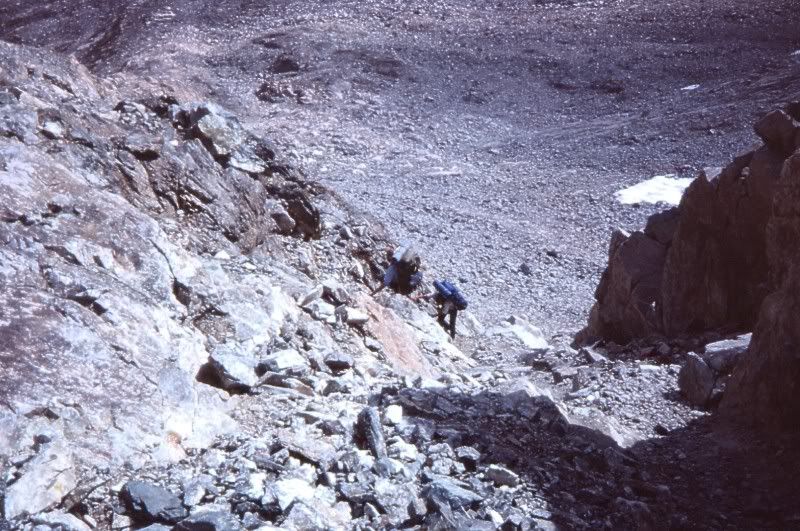
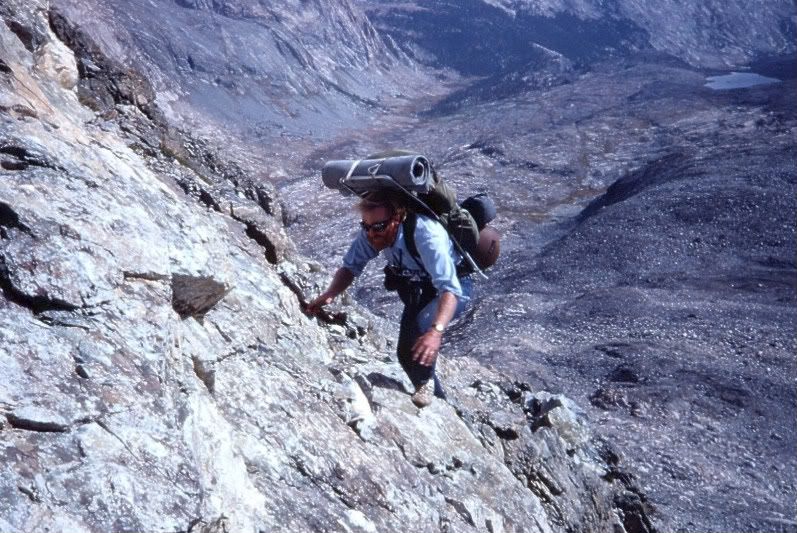
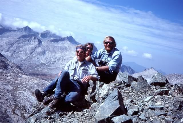
Having visited 9 Lakes Basin on my first Sierra backpack (in the early ‘70s), I’d always wondered what the other side of the Kaweahs was like (and this interest was fueled by other folks on this site!). Four years ago, my wife & I were aiming for the backside of the Kaweahs (by looping in from the North via Triple Divide Pass), but with heavy snow on an early June trip, we did not get beyond the headwaters of the Kern-Kaweah River. This time, we planned to go over Sawtooth Pass (and head in via Pants Pass or Kaweah Pass, whichever looked better), but on the appointed day, we encountered a few obstacles. First, a fallen tree blocked the Mineral King road (fortunately, two rangers arrived 5 min after we did and the delay was minimal). Second, we were told by the very helpful ranger issuing wilderness permits that her boss had been reluctant to descend the far side of Sawtooth a couple days earlier even though he had an ice axe and crampons (too icy; we had neither). Third, the marmot problem has apparently gotten worse, and folks are encouraged to bring full wraps or fences for their vehicles (we had neither). Fourth, by the time we got our permit, it was raining/hailing and there were sporadic bursts of thunder (too grey to see lightning, if there was any). We aborted, stayed overnight and got an early start the next morning at Wolverton. The weather held till Hamilton Lake and though we’d wanted to try for Precipice Lake, the clouds were just beginning to obscure Kaweah gap, so we parked at Hamilton. The next two days had a mix of every imaginable form of precipitation with the most impressive being an inch of hail and ~4 inches of snow. We almost hit trail at midday on our second day, but the transient clearing was just that, transient. Had it not cleared on day 4, we were going to bolt. But, day 4 started with brilliant sunshine and by mid-morning we hit solid snow about 300 ft below Precipice Lake and carved fresh tracks to Kaweah gap. Not surprisingly, there was little exposed ground in 9 Lakes Basin, but we found a campsite at the lake below Pants Pass just before the clouds reduced visibility to less than 10 ft. The next morning was gorgeous with warm sun (and billowing clouds in the distance), so after giving just enough time to let the snow thaw a bit we tackled Pants Pass. The west side was pretty benign, but the first ~100 ft on the East side was close to vertical, and the entire chute was coated with snow. The scenery helped quell my wife’s initial reluctance to go down and after some semi-tricky maneuvering on the top third, we got to glissade the rest. I have a hunch that Pants is appreciably harder in August, but for us it was a thrill! Unfortunately, we got two more days of miserable weather in the upper reaches of the Kern-Kaweah basin before finally being able to climb a saddle into Picket Guard basin. Even so, we got pelted by hail and snow as we reached the lower end of the basin. Nevertheless, the mini-hump into Kaweah basin was a stone’s throw away, so even when the next day opened with a winter grey sky, we hit the road. And, during the rest of the day, the sun broke through occasionally, so we could appreciate (a little) everything we’d heard about the area from Maverick, Greg (Trailblazer) and others. Yes, Kaweah basin is splendid, and our only regret is that the time we’d hope to have to wander around the basin was spent waiting out storms earlier in the trip. In spite of this, the best weather of the trip arrived the next morning, so we waited till about midday before starting our ascent of Kaweah Pass. I think that a few of the photos my wife took begin to capture some of the splendor, but the awful weather precluded any alpenglow and some of the subtler lighting effects that will make a return trip necessary. Anyway, Kaweah Pass is much more challenging than I expected it to be. The rocks that I’d been longing for during the seemingly interminable snow ascent turned out to be miserably jumbled and loose. Hence we made a very slow and cautious creep up the final ~150 ft. Fortunately, the packs were a lot lighter at this stage of the trip. Anyway, the lake that sits at ~12,400 ft (below Mt. Kaweah) was completely enshrouded in snow, as was the first several hundred feet of our descent to Chagoopa plateau. We camped by one of the small, high lakes as the early morning sunshine segued to a steel grey. It was the only day of the trip with no precipitation. The next morning came with high clouds that kept descending until we met them in the upper Big Arroyo. By mid-afternoon, the cloud bank was dense enough that it seemed that nightfall was imminent. Still, we managed to dust off a campsite below Kaweah gap and in freezing sleet packed up the next morning and reached Wolverton by early evening. During the drive down to Three Rivers the alpenglow on Moro Rock and Castle Rocks was spectacular. It was the only alpenglow of the whole trip. Still, as the saying goes, any day in the Sierras beats the best day in LA………(or the office). The final tidbit is that we “rescued” two balloons on the trip, but the third one was a shiny blue mylar star that we left near where we found it in Kaweah basin. My wife wants to see if it’s still there the next time we visit the area. I’m guessing it won’t last that long. On the other hand, it’s a BIG basin! And, it's worth the effort to get there!
CG
TR: Kaweah Basin June '09
-
cgundersen

- Topix Fanatic
- Posts: 1338
- Joined: Sun Jul 16, 2006 1:07 pm
- Experience: N/A
-
maverick

- Forums Moderator

- Posts: 11834
- Joined: Thu Apr 06, 2006 5:54 pm
- Experience: Level 4 Explorer
Re: TR: Kaweah Basin June '09
Thanks CG for the TR, to bad the weather was so challenging.
Your photo link is not activated(correctly posted) so you cannot click on it
and go to your flickr site to see your photo's.
Pants Passes eastern site is a trip, and kudos to your wife for doing it.
Kaweah Pass is nasty, but it is still better to climb it than descend it.
Your photo link is not activated(correctly posted) so you cannot click on it
and go to your flickr site to see your photo's.
Pants Passes eastern site is a trip, and kudos to your wife for doing it.
Kaweah Pass is nasty, but it is still better to climb it than descend it.
-
copeg

- Founding Member & Forums Administrator

- Posts: 2111
- Joined: Fri Oct 28, 2005 9:25 pm
- Experience: Level 4 Explorer
- Location: Menlo Park, CA
- Contact:
Re: TR: Kaweah Basin June '09
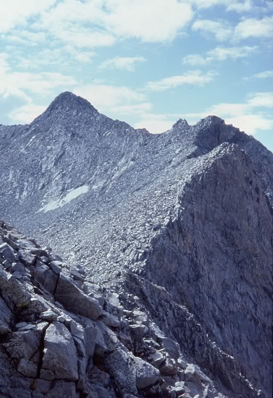
Thanks for the TR and photos! Looks like the weather made things quite interesting. Looks like a great time. Glad to hear you stuck it out and didn't bolt after the 3th day. Quick question: you've got the picture "2 View of Pants Pass from 9 Lakes Basin", which one is Pants Pass, the notch on the right?
PS The link to flickr wasn't working so I edited the link to make it work. Hope you don't mind
PS The link to flickr wasn't working so I edited the link to make it work. Hope you don't mind
-
Skibum
- Founding Member
- Posts: 236
- Joined: Sun Oct 30, 2005 4:50 pm
- Experience: N/A
- Location: Kings Canyon Nat'l Park, CA.
Re: TR: Kaweah Basin June '09
Some very nice pics.  Thanks for the TR.
-
cgundersen
- Topix Fanatic
- Posts: 1338
- Joined: Sun Jul 16, 2006 1:07 pm
- Experience: N/A
Re: TR: Kaweah Basin June '09
First, thanks to Greg for activating the photo link; second, the low point just left of center on photo #2 is what we regarded as Pants Pass. From 9 Lakes basin, it's the lowest saddle over the ridge (and, when I've seen it in Summer, it's mostly sand-gravel-scree and looks pretty tame; whereas the other side is clearly more daunting). However, from the Kern-Kaweah side, there is a much easier approach a bit South of our version of Pants Pass. Although the approach is easier, it is also higher and comes out on some very unsettling looking ridges on the 9 Lakes basin side. There are undoubtedly folks who could manage that southern route, but I'm almost certainly not one of them.
Third, yes Maverick, my wife & I were very glad that we'd done the route clockwise. Not sure we would have made it down Kaweah Pass (least, not in 1 piece). BTW, her first words at the top of Pants were: "Oh, no". But, she's a trooper. At the same time, we're really keen to hear from anyone who does Pyraqueen, because she's not too excited about going over Pants or Kaweah ever again.
CG
-
maverick
- Forums Moderator
- Posts: 11834
- Joined: Thu Apr 06, 2006 5:54 pm
- Experience: Level 4 Explorer
Re: TR: Kaweah Basin June '09
Pyra-Queen is your easiest entry/exit into Kaweah Basin.
I really liked pic's #1 and #11, the Hamilton area looks like its in the winter.
I really liked pic's #1 and #11, the Hamilton area looks like its in the winter.
-
TehipiteTom
- Founding Member
- Posts: 953
- Joined: Thu Aug 24, 2006 8:42 am
- Experience: Level 4 Explorer
Re: TR: Kaweah Basin June '09
Excellent report, great pics. Too bad the weather was so crappy, but you did make it to Kaweah Basin--which has the highest planned-to-achieved ratio of any place in the Sierra.

-
Mike M.
- Topix Expert
- Posts: 647
- Joined: Fri May 25, 2007 10:50 pm
- Experience: Level 4 Explorer
- Location: Portland, Oregon
Re: TR: Kaweah Basin June '09
Great pics CG -- I'd love to see some more, especially of the pass from both sides. My photos don't document the climb very well.
Maverick, do you have any photos of Pyra-Queen Col?
Here's a few photos I took of Pants Pass in 1981 (I also just posted these on a related thread). I've only been over the pass two times, both from the Upper Kern-Kaweah Basin down to Nine Lakes Basin.
Maverick, do you have any photos of Pyra-Queen Col?
Here's a few photos I took of Pants Pass in 1981 (I also just posted these on a related thread). I've only been over the pass two times, both from the Upper Kern-Kaweah Basin down to Nine Lakes Basin.
-
markorr
- Topix Acquainted
- Posts: 78
- Joined: Wed Jul 11, 2007 3:25 pm
- Experience: N/A
Re: TR: Kaweah Basin June '09
Thanks for the TR and pics CG, hopefully it will help with our planning for next week. Congrats for sticking it out and making the full trip in spite of all the bad weather.
I tried to do a loop out of MK last Thursday but got turned around by a white out and 100% snow coverage at Sawtooth Pass. I had no idea where to go down from there b/c visibility was about 5 feet, other than blind faith in the compass. When I got back to the car 6 hours after setting out (my shortest BP'ing trip ever) a marmot had climbed over the chicken wire fence around my car and proceeded to chew on the insulation in my engine. no major damage done though. So despite what the rangers say, if I wrap my car well enough, I'm going to leave my hood closed next time
I tried to do a loop out of MK last Thursday but got turned around by a white out and 100% snow coverage at Sawtooth Pass. I had no idea where to go down from there b/c visibility was about 5 feet, other than blind faith in the compass. When I got back to the car 6 hours after setting out (my shortest BP'ing trip ever) a marmot had climbed over the chicken wire fence around my car and proceeded to chew on the insulation in my engine. no major damage done though. So despite what the rangers say, if I wrap my car well enough, I'm going to leave my hood closed next time
-
maverick
- Forums Moderator
- Posts: 11834
- Joined: Thu Apr 06, 2006 5:54 pm
- Experience: Level 4 Explorer
Re: TR: Kaweah Basin June '09
Hi Mike M
I'll have a picture of the pass up tomorrow.
Hey Markorr, I have heard that the marmot's are out on a serious mission this year
down at MK.
I wonder why there so much worse this year than the past years, maybe because
of the bad weather?
I'll have a picture of the pass up tomorrow.
Hey Markorr, I have heard that the marmot's are out on a serious mission this year
down at MK.
I wonder why there so much worse this year than the past years, maybe because
of the bad weather?
Who is online
Users browsing this forum: cbadfish, ethoits, Google Adsense [Bot], jefffish and 58 guests