Lobe Pass Info

If you've been searching for the best source of information and stimulating discussion related to Spring/Summer/Fall backpacking, hiking and camping in the Sierra Nevada...look no further!
Post Reply
User avatar
MichaelRPetrick
Topix Acquainted
Posts: 90
Joined: Sun Apr 21, 2013 7:06 pm
Experience: Level 4 Explorer
Location: Mill Valley, CA

Lobe Pass Info

Post by MichaelRPetrick »

Howdy. Me and two friends will likely be doing Lobe Pass as part of a 3-day, 3 passes trip over Glacier Divide - (Piute, Lobe, Lamarck).

I can't find much on the pass besides what's written in Secor, and some information from the excellent Peaks for Phreaks, who I believe posts on this forum:
Since descending directly from the lowpoint of Lobe Pass would involve class 5 terrain, we headed up towards Honeymoon Peak for roughly 200 ft of distance before dropping down to the northeast. For the first hundred feet or so, we downclimbed on solid class 3 rock. After that, the terrain quickly turned into sandy steep class 2. As we arrived at the moraine below, we hit the expected tedious rock hopping which would last for another 30 minutes. As we neared Lobe Lakes, the moraine ended and was replaced by nice grassy slopes. For the first time since we began the traverse, we were hit with a tirade of mosquitoes as we dropped below treeline.
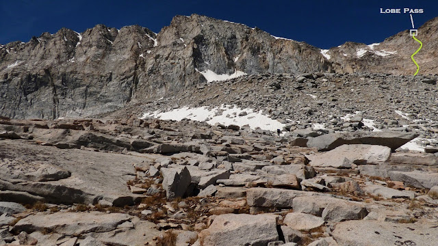
I'm wondering if anyone who has done the pass has anything else to add, as the top couple hundred feet do look a bit beyond the Class 2 Secor describes. Is there any trick to keeping it class 2?

From Peaks for Phreaks:

Image

From Google Earth, a snowy shot of Lobe Pass. Which part of the saddle is it best to aim for from below?
You do not have the required permissions to view the files attached to this post.
User avatar
seanr
Topix Regular
Posts: 285
Joined: Thu Feb 06, 2014 9:46 am
Experience: Level 4 Explorer

Re: Lobe Pass Info

Post by seanr »

I'm not sure how often he checks in here and he will be out hiking sometimes, but his website invites you to e-mail him: eric.jsc@gmail.com 

Are you thinking you would not want to deal with any class 3 moves if unavoidable?


Sent from my XT1254 using Tapatalk
Last edited by seanr on Thu Jul 07, 2016 10:15 pm, edited 1 time in total.
User avatar
maverick
Forums Moderator
Forums Moderator
Posts: 11834
Joined: Thu Apr 06, 2006 5:54 pm
Experience: Level 4 Explorer

Re: Lobe Pass Info

Post by maverick »

Going up from Lobe Lake to the pass head a little north to avoid the steeper ledges, once at the top descend down to around 12000 from where you traverse north above Lake 11236 and the descend down towards the middle lake in the basin, do not recall any part being over class 2 while ascending from Lobe Lake, steep yes, but nothing beyond a solid class 2 Michael. If you proficient in route finding you should have no problem keeping it class 2.

PS You have done Valor so this should not be a big deal.
Professional Sierra Landscape Photographer

I don't give out specific route information, my belief is that it takes away from the whole adventure spirit of a trip, if you need every inch planned out, you'll have to get that from someone else.

Have a safer backcountry experience by using the HST ReConn Form 2.0, named after Larry Conn, a HST member: http://reconn.org
User avatar
MichaelRPetrick
Topix Acquainted
Posts: 90
Joined: Sun Apr 21, 2013 7:06 pm
Experience: Level 4 Explorer
Location: Mill Valley, CA

Re: Lobe Pass Info

Post by MichaelRPetrick »

Are you thinking you would not want to deal with any class 3 moves if unavoidable?
Can deal with class 3 moves, but some folks in my party would definitely prefer they not be of a particularly prolonged or exposed nature.
Going up from Lobe Lake to the pass head a little north to avoid the steeper ledges, once at the top descend down to around 12000 from where you traverse north above Lake 11236 and the descend down towards the middle lake in the basin, do not recall any part being over class 2 while ascending from Lobe Lake, steep yes, but nothing beyond a solid class 2 Michael. If you proficient in route finding you should have no problem keeping it class 2.
Thanks for the Class 2 confirmation Maverick.

BTW, most of my cross-country experience is from doing the Sierra High Route in 2013, so I'm used to doing passes with lots of extant discussion on route quirks. I'm not worried about micro-routefinding and am pretty good at taking the most sensible path, but I just want to make sure I'm not bearing towards the wrong notch in the skyline on autopilot.
P1130859.JPG
The above picture from Eric is what had me most concerned, but I imagine there's a lot of foreshortening going on. I remember waking up at East Lake below Mt. Brewer the morning before I climbed Ouzel Creek / East Ridge and thinking to myself "How in the !@#$ is the top of that thing Class 2!?" But lo and behold it was.
You do not have the required permissions to view the files attached to this post.
Last edited by MichaelRPetrick on Fri Jul 08, 2016 1:59 pm, edited 2 times in total.
User avatar
maverick
Forums Moderator
Forums Moderator
Posts: 11834
Joined: Thu Apr 06, 2006 5:54 pm
Experience: Level 4 Explorer

Re: Lobe Pass Info

Post by maverick »

I'm not worried about micro-routefinding and am pretty good at taking the most sensible path, but I just want to make sure I'm not bearing towards the wrong notch in the skyline on autopilot.
As you are certainly aware finding the optimal route while descend is always more more difficult, so a class 2 can easily become more difficult while descending as opposed to ascending.
Personally I do not always go by the so called official route or pass described by Secor, many times I have found easier routes than the so called traditional ones.
Professional Sierra Landscape Photographer

I don't give out specific route information, my belief is that it takes away from the whole adventure spirit of a trip, if you need every inch planned out, you'll have to get that from someone else.

Have a safer backcountry experience by using the HST ReConn Form 2.0, named after Larry Conn, a HST member: http://reconn.org
User avatar
MichaelRPetrick
Topix Acquainted
Posts: 90
Joined: Sun Apr 21, 2013 7:06 pm
Experience: Level 4 Explorer
Location: Mill Valley, CA

Re: Lobe Pass Info

Post by MichaelRPetrick »

Personally I do not always go by the so called official route or pass described by Secor, many times I have found easier routes than the so called traditional ones
A good thing for me to keep in mind, lest I try to recapitulate guidebooks routes. :D For example, Secor says the west side of Valor is steep talus, whereas the route I descended was so easy I barely had to use my hands.
User avatar
maverick
Forums Moderator
Forums Moderator
Posts: 11834
Joined: Thu Apr 06, 2006 5:54 pm
Experience: Level 4 Explorer

Re: Lobe Pass Info

Post by maverick »

A good thing for me to keep in mind, lest I try to recapitulate guidebooks routes. :D For example, Secor says the west side of Valor is steep talus, whereas the route I descended was so easy I barely had to use my hands.
Exactly, a little scouting and some navigational prowess can make things much easier, always following a guide book or ducks/use trail leads to dependency, mountain travel should be about freedom and using ones experience and mind to solve navigational issues.
Just to be clear, only advocate this for those with solid experience in backcountry travel and navigational skills.
Professional Sierra Landscape Photographer

I don't give out specific route information, my belief is that it takes away from the whole adventure spirit of a trip, if you need every inch planned out, you'll have to get that from someone else.

Have a safer backcountry experience by using the HST ReConn Form 2.0, named after Larry Conn, a HST member: http://reconn.org
Post Reply

Who is online

Users browsing this forum: No registered users and 56 guests