Here we go, let's hope there will not be many of these this year.
Chimney Fire: PCT closed between Hwy 178 and Kennedy Meadows.
http://inciweb.nwcg.gov/incident/4757/
2016 Fire and Smoke Impact Reports / Maps
-
maverick

- Forums Moderator

- Posts: 11841
- Joined: Thu Apr 06, 2006 5:54 pm
- Experience: Level 4 Explorer
2016 Fire and Smoke Impact Reports / Maps
Professional Sierra Landscape Photographer
I don't give out specific route information, my belief is that it takes away from the whole adventure spirit of a trip, if you need every inch planned out, you'll have to get that from someone else.
Have a safer backcountry experience by using the HST ReConn Form 2.0, named after Larry Conn, a HST member: http://reconn.org
-
ExploreABitMore

- Topix Regular
- Posts: 168
- Joined: Thu Jan 11, 2007 2:38 pm
- Experience: Level 4 Explorer
- Location: Ridgecrest, CA
- Contact:
Chimney Fire
I heard this might be mostly contained already. Don't see much from Ridgecrest currently (unlike yesterday).
But , seems to conflict with the %10 on report.
Hoping for the best!
But , seems to conflict with the %10 on report.
Hoping for the best!
Last edited by maverick on Sat Jun 25, 2016 11:20 am, edited 1 time in total.
Reason: subject matter
Reason: subject matter
Sierra Nevada, Mojave Desert, Night Sky Photography: http://www.evanthomasphoto.com/
-
maverick
- Forums Moderator
- Posts: 11841
- Joined: Thu Apr 06, 2006 5:54 pm
- Experience: Level 4 Explorer
Chimney Fire
Fire has increased to 1,826 acres, and is 33% contained.
http://inciweb.nwcg.gov/incident/4757/
http://inciweb.nwcg.gov/incident/4757/
Professional Sierra Landscape Photographer
I don't give out specific route information, my belief is that it takes away from the whole adventure spirit of a trip, if you need every inch planned out, you'll have to get that from someone else.
Have a safer backcountry experience by using the HST ReConn Form 2.0, named after Larry Conn, a HST member: http://reconn.org
I don't give out specific route information, my belief is that it takes away from the whole adventure spirit of a trip, if you need every inch planned out, you'll have to get that from someone else.
Have a safer backcountry experience by using the HST ReConn Form 2.0, named after Larry Conn, a HST member: http://reconn.org
-
ERIC

- Your Humble Host & Forums Administrator

- Posts: 3254
- Joined: Fri Oct 28, 2005 9:13 am
- Experience: Level 4 Explorer
- Location: between the 916 and 661
2016 Sierra Nevada Fire/Smoke Maps & Reports
The CAL FIRE map below displays general locations of major fires burning in the High Sierra Nevada and throughout the state of California. Fire locations are approximate.
Archive Maps from Previous Years
Other useful resources:
http://californiasmokeinfo.blogspot.com/
https://worldview.earthdata.nasa.gov/?p ... 6447125049
http://wxshift.com/news/us-wildfires-one-map
Archive Maps from Previous Years
Other useful resources:
http://californiasmokeinfo.blogspot.com/
https://worldview.earthdata.nasa.gov/?p ... 6447125049
http://wxshift.com/news/us-wildfires-one-map
New members, please consider giving us an intro!
Follow us on Twitter @HighSierraTopix. Use hashtags #SIERRAPHILE #GotSierra? #GotMountains?
Follow us on Facebook: https://www.facebook.com/HighSierraTopix
Follow us on Twitter @HighSierraTopix. Use hashtags #SIERRAPHILE #GotSierra? #GotMountains?
Follow us on Facebook: https://www.facebook.com/HighSierraTopix
-
Leadfoot83
- Topix Novice
- Posts: 8
- Joined: Tue Feb 23, 2016 9:45 pm
- Experience: N/A
Re: 2016 Real-time Sierra Nevada Fire Map
Great information! Thank you
-
maverick
- Forums Moderator
- Posts: 11841
- Joined: Thu Apr 06, 2006 5:54 pm
- Experience: Level 4 Explorer
Marina Fire (Lee Vining) 6/24
Professional Sierra Landscape Photographer
I don't give out specific route information, my belief is that it takes away from the whole adventure spirit of a trip, if you need every inch planned out, you'll have to get that from someone else.
Have a safer backcountry experience by using the HST ReConn Form 2.0, named after Larry Conn, a HST member: http://reconn.org
I don't give out specific route information, my belief is that it takes away from the whole adventure spirit of a trip, if you need every inch planned out, you'll have to get that from someone else.
Have a safer backcountry experience by using the HST ReConn Form 2.0, named after Larry Conn, a HST member: http://reconn.org
-
Fly Guy Dave

- Topix Expert
- Posts: 580
- Joined: Sat Jan 07, 2012 9:27 am
- Experience: Level 4 Explorer
- Contact:
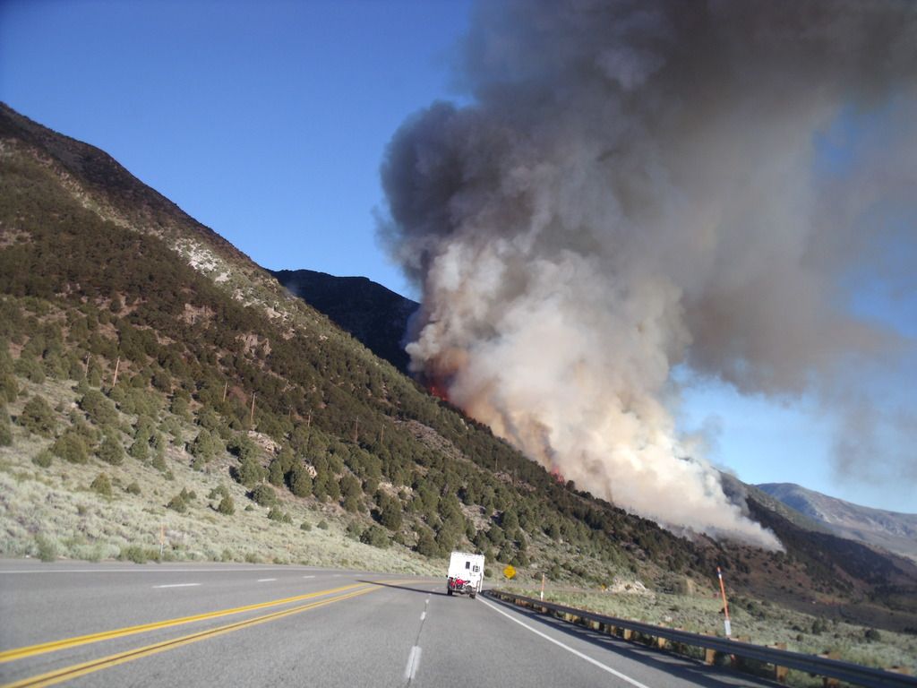
Marina Fire
Here's a pic I took of the Marina Fire this morning when I was driving north on 395. I think I was one of the last people they let through before they shut down the Highway.
"Yeah, well, you know, that's just, like, your opinion, man." --The Dude (Jeff Lebowski)
Some pics of native salmonids: http://flyguydave.wordpress.com/" onclick="window.open(this.href);return false;
Some pics of native salmonids: http://flyguydave.wordpress.com/" onclick="window.open(this.href);return false;
-
maverick
- Forums Moderator
- Posts: 11841
- Joined: Thu Apr 06, 2006 5:54 pm
- Experience: Level 4 Explorer
Marina Fire
Has grown to 350 acres.
Professional Sierra Landscape Photographer
I don't give out specific route information, my belief is that it takes away from the whole adventure spirit of a trip, if you need every inch planned out, you'll have to get that from someone else.
Have a safer backcountry experience by using the HST ReConn Form 2.0, named after Larry Conn, a HST member: http://reconn.org
I don't give out specific route information, my belief is that it takes away from the whole adventure spirit of a trip, if you need every inch planned out, you'll have to get that from someone else.
Have a safer backcountry experience by using the HST ReConn Form 2.0, named after Larry Conn, a HST member: http://reconn.org
-
cfudge

- Topix Newbie
- Posts: 2
- Joined: Thu Jun 09, 2016 1:01 pm
- Experience: Level 2 Backpacker
Marina Fire
How/will this affect people trying to get into Tuolumne Meadows? I'm supposed to start the 30th. Hopefully this will get contained soon!
-
Fly Guy Dave
- Topix Expert
- Posts: 580
- Joined: Sat Jan 07, 2012 9:27 am
- Experience: Level 4 Explorer
- Contact:
Marina Fire
Cornelius-cfudge wrote:How/will this affect people trying to get into Tuolumne Meadows? I'm supposed to start the 30th. Hopefully this will get contained soon!
No way of knowing. I would suggest you monitor the link that Maverick provided:
http://inciweb.nwcg.gov/incident/4809/
Unfortunately, it has now grown to 600 acres.
And I agree with you, I hope it is contained soon!
--F.G. Dave
"Yeah, well, you know, that's just, like, your opinion, man." --The Dude (Jeff Lebowski)
Some pics of native salmonids: http://flyguydave.wordpress.com/" onclick="window.open(this.href);return false;
Some pics of native salmonids: http://flyguydave.wordpress.com/" onclick="window.open(this.href);return false;
Who is online
Users browsing this forum: frozenintime, sdchesnut, wildhiker and 111 guests