Hell doth freeze over! The hot and cold of Henry Coe.
The weather report was perfect (highs low70’s, low’s 40’s 0%chance rain) and I was itching to get out. A bit early in the season, but I decided to do my annual Henry Coe “kick start” grueling shake down. As usual, I had five different travel plans, and did not decide until the last minute. I had not looped from Headquarters in many years. I packed light but took my usual duffle bag of “more stuff” to decide the last minute at the trailhead. By the time I reached the headquarters at 11AM (an hour longer drive than Hunting Hollow trailhead) and paid the outrageous fees $39 for three nights out, and threw in a pair of thermal leggings, I headed down the trail at noon, not in the best of moods, wishing instead that I had gone to Hunting Hollow where one can park on non-Coe land and save the silly $8 a night parking fee (still pay a $5 night fee to camp). A pet peeve of mine is excessive fees at state parks.
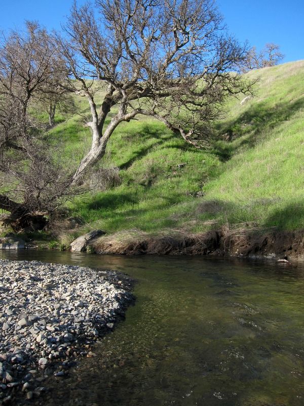
I only had 5-6 hours of remaining daylight. The Springs and Madrone Soda Springs Trails were beautiful, the shady cool welcome as it was actually hot. The last time I walked this trail with its dozen-plus creek crossings, I had to wade nearly each one. This year, the flows are so low that I could hop rocks. When I reached China Hole I was happy to wade across knee-deep Coyote Creek. The Narrows “trail” really is not a trail. It soon ended and I was stuck on a steep slope 100 feet above the creek, blocked by impenetrable brush. I dropped to the creek without falling and waded across, miscalculating the depth of the crotch deep water and then proceeded upstream walking in the stream. I had planned on camping at Los Cruzeros but it was 3PM and I decided to try to make it farther. As I climbed up the Willow Ridge Trail my clothing quickly dried. I stopped at the little spring near the top to refill my water bottle. The blistering hot Willow Ridge Road does not have a bit of shade. It was soon clear that I did not have enough daylight, energy or water, to make it to Mississippi Lake so I dropped down the Rat Springs Trail to Pacheco Creek reaching a nice flat spot and set up. I quickly got out of my sweaty hiking clothes and put on all my clothing. The temperature dropped quickly, dew jumped out of the air soaking everything. I had walked 9.5 miles in five and a quarter hours with 2050 feet of up and down. The roller-coaster hills of Henry Coe had already beaten me up. I ached, chugged down Advil and slept. About midnight I awoke cold and put on more clothes. This was no 40-degree night. The dew had turned to a layer of frost. Hell had frozen over.
[rimg]http://i249.photobucket.com/albums/gg23 ... ited-1.jpg[/rimg]
Springs Trail
[rimg]http://i249.photobucket.com/albums/gg23 ... ited-1.jpg[/rimg]
Springs Trail
[rimg]http://i249.photobucket.com/albums/gg23 ... ited-1.jpg[/rimg]
The Narrows at Coyote Creek, ford
[rimg]http://i249.photobucket.com/albums/gg23 ... ited-1.jpg[/rimg]
Wading the creek near Los Cruzeros
TR: Henry Coe, Feb 22-25, 2016
-
Wandering Daisy

- Topix Docent
- Posts: 6689
- Joined: Sun Jan 24, 2010 8:19 pm
- Experience: N/A
- Location: Fair Oaks CA (Sacramento area)
- Contact:
![[rimg]http://i249.photobucket.com/albums/gg23 ... ited-1.jpg[/rimg]](http://s249.photobucket.com/user/npallister/media/2016_Henry%20Coe/IMG_3788_edited-1.jpg.html)
![[rimg]http://i249.photobucket.com/albums/gg23 ... ited-1.jpg[/rimg]](http://s249.photobucket.com/user/npallister/media/2016_Henry%20Coe/IMG_3786_edited-1.jpg.html)
![[rimg]http://i249.photobucket.com/albums/gg23 ... ited-1.jpg[/rimg]](http://s249.photobucket.com/user/npallister/media/2016_Henry%20Coe/IMG_3653_edited-1.jpg.html)
![[rimg]http://i249.photobucket.com/albums/gg23 ... ited-1.jpg[/rimg]](http://s249.photobucket.com/user/npallister/media/2016_Henry%20Coe/IMG_3656_edited-1.jpg.html)
-
Wandering Daisy
- Topix Docent
- Posts: 6689
- Joined: Sun Jan 24, 2010 8:19 pm
- Experience: N/A
- Location: Fair Oaks CA (Sacramento area)
- Contact:
Re: TR: Henry Coe, Feb 22-25, 2016
Day 2
At 7:30 I was still in my icy tunnel, but being deep in the canyon it was clear that I would get nowhere if I waited for morning sun. I cursed my Tarptent Moment as I shoved the frozen wet thing in the bag. I did not bring gloves. I had the pleasure of putting on cold wet hiking clothes and nearly ran down the trail to get warm. Finally at 10AM the sun hit the depths of the canyon. Soon the beautiful little valley made me forget my discomfort. I reached Pacheco Camp, a beautiful open sunny established campsite with picnic tables and out buildings. It would have been nice if I were able to reach this last night. I now had about 4 miles of roller-coaster walking on the Coit Road. Quickly I was again roasting in hell. The signs at Oristemba Creek were confusing to say the least. Thankfully I had been here before so trudged north on the much larger road to Oristemba Corrals where I ate a late lunch at a picnic table in the shade of a huge oak. I was hurting – stiff and sore, especially those “downhill” muscles. I reached Hartman Trail at 2:30 and decided that again, I would not be able to make it to Mississippi Lake, not due to lack of daylight but lack of energy. I hiked up the road a ways to see if I could find a better campsite, but decided the little site at the trail junction was better so returned and set up camp. I had time to take a bath and wash clothes. I poked around and had an early supper in daylight and was able to dry everything. I went to bed early and listened to two hours of music. I ached even more than the previous night. Again, dew point hit, and immediately the tent was soaked inside and out. Another cold, calm cloudless, moonlight night! The tent turned to frost even earlier. It was another 9.5 mile day in five and a quarter hour, but with only 1100 feet up and down.
[rimg]http://i249.photobucket.com/albums/gg23 ... ited-1.jpg[/rimg]
Pacheco Creek
[rimg]http://i249.photobucket.com/albums/gg23 ... ited-1.jpg[/rimg]
Oristemba Creek
[rimg]http://i249.photobucket.com/albums/gg23 ... ited-1.jpg[/rimg]
Camp at Hartman Trail junction on Oristemba Creek
[rimg]http://i249.photobucket.com/albums/gg23 ... ited-1.jpg[/rimg]
Sunset on Oristemba Creek
At 7:30 I was still in my icy tunnel, but being deep in the canyon it was clear that I would get nowhere if I waited for morning sun. I cursed my Tarptent Moment as I shoved the frozen wet thing in the bag. I did not bring gloves. I had the pleasure of putting on cold wet hiking clothes and nearly ran down the trail to get warm. Finally at 10AM the sun hit the depths of the canyon. Soon the beautiful little valley made me forget my discomfort. I reached Pacheco Camp, a beautiful open sunny established campsite with picnic tables and out buildings. It would have been nice if I were able to reach this last night. I now had about 4 miles of roller-coaster walking on the Coit Road. Quickly I was again roasting in hell. The signs at Oristemba Creek were confusing to say the least. Thankfully I had been here before so trudged north on the much larger road to Oristemba Corrals where I ate a late lunch at a picnic table in the shade of a huge oak. I was hurting – stiff and sore, especially those “downhill” muscles. I reached Hartman Trail at 2:30 and decided that again, I would not be able to make it to Mississippi Lake, not due to lack of daylight but lack of energy. I hiked up the road a ways to see if I could find a better campsite, but decided the little site at the trail junction was better so returned and set up camp. I had time to take a bath and wash clothes. I poked around and had an early supper in daylight and was able to dry everything. I went to bed early and listened to two hours of music. I ached even more than the previous night. Again, dew point hit, and immediately the tent was soaked inside and out. Another cold, calm cloudless, moonlight night! The tent turned to frost even earlier. It was another 9.5 mile day in five and a quarter hour, but with only 1100 feet up and down.
[rimg]http://i249.photobucket.com/albums/gg23 ... ited-1.jpg[/rimg]
![[rimg]http://i249.photobucket.com/albums/gg23 ... ited-1.jpg[/rimg]](http://s249.photobucket.com/user/npallister/media/2016_Henry%20Coe/IMG_3670_edited-1.jpg.html)
Pacheco Creek
[rimg]http://i249.photobucket.com/albums/gg23 ... ited-1.jpg[/rimg]
![[rimg]http://i249.photobucket.com/albums/gg23 ... ited-1.jpg[/rimg]](http://s249.photobucket.com/user/npallister/media/2016_Henry%20Coe/IMG_3685_edited-1.jpg.html)
Oristemba Creek
[rimg]http://i249.photobucket.com/albums/gg23 ... ited-1.jpg[/rimg]
![[rimg]http://i249.photobucket.com/albums/gg23 ... ited-1.jpg[/rimg]](http://s249.photobucket.com/user/npallister/media/2016_Henry%20Coe/IMG_3686_edited-1.jpg.html)
Camp at Hartman Trail junction on Oristemba Creek
[rimg]http://i249.photobucket.com/albums/gg23 ... ited-1.jpg[/rimg]
![[rimg]http://i249.photobucket.com/albums/gg23 ... ited-1.jpg[/rimg]](http://s249.photobucket.com/user/npallister/media/2016_Henry%20Coe/IMG_3702_edited-1.jpg.html)
Sunset on Oristemba Creek
-
Wandering Daisy
- Topix Docent
- Posts: 6689
- Joined: Sun Jan 24, 2010 8:19 pm
- Experience: N/A
- Location: Fair Oaks CA (Sacramento area)
- Contact:
Re: TR: Henry Coe, Feb 22-25, 2016
Day 3
This time I was camped in a more open site. I bundled up and got out of the tent at 7AM and cooked breakfast. Water had frozen in a bottle I had left away from the tent. I really cannot imagine starting a cold day like this without a hot breakfast! To my surprise a truck rumbled down the road- the rancher and his three dogs – first person I had seen in two days. I waved, he did not wave back. Another battle with the dxxx!! tent! I used my pot cozy as an ice scraper sending frost flying in all directions. Finally the sun poked above the hillside. Thank goodness! Another half hour delay just to dry the tent. I started up the Hartman trail and immediately it disappeared. I decided that I may be one ridge too far north so I headed south. If I did not find the trail I would return and go out on the road. One does not do much cross-country at Henry Coe- navigation is really difficult and brush impenetrable. Thankfully I found the trail and headed up. Hartman Trail is steep one! It was definitely smart to save this until morning. There are very limited water sources and you either make it to your destination or go dry. After over 1000 feet gain I was on the top of a hill and sweating hot! Of course, there were now several ups and downs on the ridge to reach the Mississippi Ridge Road. As I reached Mississippi Lake I regretted that I could not have made it here. There is a nice campground and the lake is beautiful.
After lunch on the hillside I started south on the Willow Ridge Road. I had walked this road about 10 years earlier and cussed it. I thought maybe I just was having a bad day then. No, Willow Ridge Road is pure hell. Hardly a speck of shade, almost five miles of walking, facing the hot sun, nothing but roller-coaster hills, a thousand little tortures to sore muscles adding up to 1,500 feet of ups and downs! I told myself that when I got home I would make myself write 1000 times, “never walk Willow Ridge road”. I took a break when I reached the Willow Ridge Trail, the same trail I had used two days earlier. I dropped down 1200 feet to Los Cruzeros and found a most wonderful campsite. It was only 3PM. The creek here has deep pools with tiny fingerling fish. I hopped in. The cool water felt great! The campsite was above the creek, with a nice rock outcrop to lean against, a big oak tree to hang the food (and dry the tent next morning), a smooth flat grassy tent site, great view and sunshine until nearly 5PM. Perfect! The 6 hour hike had beaten me up again- 8.6 miles and 2600 feet up and down. The frog chorus was so loud I had to use ear plugs. Earlier I even caught two frogs in the act!
[rimg]http://i249.photobucket.com/albums/gg23 ... ited-2.jpg[/rimg]
Mississippi Lake
[rimg]http://i249.photobucket.com/albums/gg23 ... ited-1.jpg[/rimg]
Moss hanging off trees on Willow Ridge Trail
[rimg]http://i249.photobucket.com/albums/gg23 ... ited-1.jpg[/rimg]
Los Cruzeros campsite
[rimg]http://i249.photobucket.com/albums/gg23 ... ited-2.jpg[/rimg]
Bath Time!
[rimg]http://i249.photobucket.com/albums/gg23 ... ited-1.jpg[/rimg]
[rimg]http://i249.photobucket.com/albums/gg23 ... ited-1.jpg[/rimg]
Frog Valentines Day
This time I was camped in a more open site. I bundled up and got out of the tent at 7AM and cooked breakfast. Water had frozen in a bottle I had left away from the tent. I really cannot imagine starting a cold day like this without a hot breakfast! To my surprise a truck rumbled down the road- the rancher and his three dogs – first person I had seen in two days. I waved, he did not wave back. Another battle with the dxxx!! tent! I used my pot cozy as an ice scraper sending frost flying in all directions. Finally the sun poked above the hillside. Thank goodness! Another half hour delay just to dry the tent. I started up the Hartman trail and immediately it disappeared. I decided that I may be one ridge too far north so I headed south. If I did not find the trail I would return and go out on the road. One does not do much cross-country at Henry Coe- navigation is really difficult and brush impenetrable. Thankfully I found the trail and headed up. Hartman Trail is steep one! It was definitely smart to save this until morning. There are very limited water sources and you either make it to your destination or go dry. After over 1000 feet gain I was on the top of a hill and sweating hot! Of course, there were now several ups and downs on the ridge to reach the Mississippi Ridge Road. As I reached Mississippi Lake I regretted that I could not have made it here. There is a nice campground and the lake is beautiful.
After lunch on the hillside I started south on the Willow Ridge Road. I had walked this road about 10 years earlier and cussed it. I thought maybe I just was having a bad day then. No, Willow Ridge Road is pure hell. Hardly a speck of shade, almost five miles of walking, facing the hot sun, nothing but roller-coaster hills, a thousand little tortures to sore muscles adding up to 1,500 feet of ups and downs! I told myself that when I got home I would make myself write 1000 times, “never walk Willow Ridge road”. I took a break when I reached the Willow Ridge Trail, the same trail I had used two days earlier. I dropped down 1200 feet to Los Cruzeros and found a most wonderful campsite. It was only 3PM. The creek here has deep pools with tiny fingerling fish. I hopped in. The cool water felt great! The campsite was above the creek, with a nice rock outcrop to lean against, a big oak tree to hang the food (and dry the tent next morning), a smooth flat grassy tent site, great view and sunshine until nearly 5PM. Perfect! The 6 hour hike had beaten me up again- 8.6 miles and 2600 feet up and down. The frog chorus was so loud I had to use ear plugs. Earlier I even caught two frogs in the act!
[rimg]http://i249.photobucket.com/albums/gg23 ... ited-2.jpg[/rimg]
![[rimg]http://i249.photobucket.com/albums/gg23 ... ited-2.jpg[/rimg]](http://s249.photobucket.com/user/npallister/media/2016_Henry%20Coe/IMG_3717_edited-2.jpg.html)
Mississippi Lake
[rimg]http://i249.photobucket.com/albums/gg23 ... ited-1.jpg[/rimg]
![[rimg]http://i249.photobucket.com/albums/gg23 ... ited-1.jpg[/rimg]](http://s249.photobucket.com/user/npallister/media/2016_Henry%20Coe/IMG_3740_edited-1.jpg.html)
Moss hanging off trees on Willow Ridge Trail
[rimg]http://i249.photobucket.com/albums/gg23 ... ited-1.jpg[/rimg]
![[rimg]http://i249.photobucket.com/albums/gg23 ... ited-1.jpg[/rimg]](http://s249.photobucket.com/user/npallister/media/2016_Henry%20Coe/IMG_3745_edited-1.jpg.html)
Los Cruzeros campsite
[rimg]http://i249.photobucket.com/albums/gg23 ... ited-2.jpg[/rimg]
![[rimg]http://i249.photobucket.com/albums/gg23 ... ited-2.jpg[/rimg]](http://s249.photobucket.com/user/npallister/media/2016_Henry%20Coe/IMG_3748_edited-2.jpg.html)
Bath Time!

[rimg]http://i249.photobucket.com/albums/gg23 ... ited-1.jpg[/rimg]
![[rimg]http://i249.photobucket.com/albums/gg23 ... ited-1.jpg[/rimg]](http://s249.photobucket.com/user/npallister/media/2016_Henry%20Coe/IMG_3758_edited-1.jpg.html)
[rimg]http://i249.photobucket.com/albums/gg23 ... ited-1.jpg[/rimg]
![[rimg]http://i249.photobucket.com/albums/gg23 ... ited-1.jpg[/rimg]](http://s249.photobucket.com/user/npallister/media/2016_Henry%20Coe/IMG_3761_edited-1.jpg.html)
Frog Valentines Day
-
Wandering Daisy
- Topix Docent
- Posts: 6689
- Joined: Sun Jan 24, 2010 8:19 pm
- Experience: N/A
- Location: Fair Oaks CA (Sacramento area)
- Contact:
Re: TR: Henry Coe, Feb 22-25, 2016
Day 4
It was a bit warmer night- it did not drop to dew point until early morning. Frost was just forming as I got out for breakfast at 6:30. Within minutes I again had a frosty tent. The floor now leaked, and I even had water between my sleeping pad and sleeping bag, which was also wet. I swear that the tent is a condensation chamber! Sun hit relatively early. The aches and pains finally had subsided, I could actually walk, not hobble around, this morning. I could return via the Narrows, wading in the water, but decided instead to take the road to Poverty Flat. It was 560 feet more gain, but actually saved time over the difficult wading. I did not take a break until I reached Manzanita Point. Then it was a quick walk back to my car by noon. This was my easiest day- 5.8 miles and 2000 feet gain. There were several day-hikers admiring the flowers and birds. Other than these folks, I had only seen the rancher and one park person in trucks in the four days.
Henry Coe Park is amazing. You do not have to make it a death-march; I only do this to get in shape. If taken more slowly, hiking here is very fun. It is very hilly so going light is preferable- I only carried 20 pounds. There are even several lakes with fish. Although too early for the oak trees with leaves, the flowers were starting to bloom and the hillsides covered with vibrant new green grass. This time there were no ticks or mosquitoes, probably because of the freezing nights. I also realize that the NWS forecasts are only accurate for the ridges. The valleys are 10-15 degrees colder when it is clear and calm. I also now am totally convinced that I need a double walled tent!
[rimg]http://i249.photobucket.com/albums/gg23 ... ited-1.jpg[/rimg]
Up the road to start the day
[rimg]http://i249.photobucket.com/albums/gg23 ... ited-1.jpg[/rimg]
Poverty Flat Road
[rimg]http://i249.photobucket.com/albums/gg23 ... ited-1.jpg[/rimg]
Creek at Poverty Flat
It was a bit warmer night- it did not drop to dew point until early morning. Frost was just forming as I got out for breakfast at 6:30. Within minutes I again had a frosty tent. The floor now leaked, and I even had water between my sleeping pad and sleeping bag, which was also wet. I swear that the tent is a condensation chamber! Sun hit relatively early. The aches and pains finally had subsided, I could actually walk, not hobble around, this morning. I could return via the Narrows, wading in the water, but decided instead to take the road to Poverty Flat. It was 560 feet more gain, but actually saved time over the difficult wading. I did not take a break until I reached Manzanita Point. Then it was a quick walk back to my car by noon. This was my easiest day- 5.8 miles and 2000 feet gain. There were several day-hikers admiring the flowers and birds. Other than these folks, I had only seen the rancher and one park person in trucks in the four days.
Henry Coe Park is amazing. You do not have to make it a death-march; I only do this to get in shape. If taken more slowly, hiking here is very fun. It is very hilly so going light is preferable- I only carried 20 pounds. There are even several lakes with fish. Although too early for the oak trees with leaves, the flowers were starting to bloom and the hillsides covered with vibrant new green grass. This time there were no ticks or mosquitoes, probably because of the freezing nights. I also realize that the NWS forecasts are only accurate for the ridges. The valleys are 10-15 degrees colder when it is clear and calm. I also now am totally convinced that I need a double walled tent!
[rimg]http://i249.photobucket.com/albums/gg23 ... ited-1.jpg[/rimg]
![[rimg]http://i249.photobucket.com/albums/gg23 ... ited-1.jpg[/rimg]](http://s249.photobucket.com/user/npallister/media/2016_Henry%20Coe/IMG_3767_edited-1.jpg.html)
Up the road to start the day
[rimg]http://i249.photobucket.com/albums/gg23 ... ited-1.jpg[/rimg]
![[rimg]http://i249.photobucket.com/albums/gg23 ... ited-1.jpg[/rimg]](http://s249.photobucket.com/user/npallister/media/2016_Henry%20Coe/IMG_3777_edited-1.jpg.html)
Poverty Flat Road
[rimg]http://i249.photobucket.com/albums/gg23 ... ited-1.jpg[/rimg]
![[rimg]http://i249.photobucket.com/albums/gg23 ... ited-1.jpg[/rimg]](http://s249.photobucket.com/user/npallister/media/2016_Henry%20Coe/IMG_3782_edited-1.jpg.html)
Creek at Poverty Flat
-
Wandering Daisy
- Topix Docent
- Posts: 6689
- Joined: Sun Jan 24, 2010 8:19 pm
- Experience: N/A
- Location: Fair Oaks CA (Sacramento area)
- Contact:
Re: TR: Henry Coe, Feb 22-25, 2016
This is what I love about living in California. The previous post on Mt. Lassen, shows that in the same time period, you can hike in Spring conditions full of flowers and green grass, or, ski into the depths of winter! Or you could go to the ocean and hike for days with waves splashing! Or go to the desert.
-
TehipiteTom
- Founding Member
- Posts: 953
- Joined: Thu Aug 24, 2006 8:42 am
- Experience: Level 4 Explorer
Re: TR: Henry Coe, Feb 22-25, 2016
Great trip report! I need to do another overnight down there...it's been way too long.
Coe seems to be the land of cold sinks. I camped at Skeels Meadow once and had the same experience as you, with thick frost on my tent and all. Up the slopes a ways it was probably 10-15 degrees warmer.
Coe seems to be the land of cold sinks. I camped at Skeels Meadow once and had the same experience as you, with thick frost on my tent and all. Up the slopes a ways it was probably 10-15 degrees warmer.
-
old and slow
- Topix Acquainted
- Posts: 73
- Joined: Wed Jun 05, 2013 8:55 am
- Experience: Level 2 Backpacker
- Location: Monterey Bay
Re: TR: Henry Coe, Feb 22-25, 2016
Great TR. Henry Coe really is a tough workout with all those endless ups and downs. Brings back memories of a trip I went on with my younger (but backpacking experienced) son in April 2008 on a loop from Park HQ spending nights at Poverty Flat and Upper Camp. My older (not-in-shape) son insisted on coming along despite warnings it was going to be a difficult trip and that he might enjoy an upcoming hike to Point Reyes more. Anyway, he came along and suffered greatly but stoically. I think he has finally forgiven me!
Btw, I like all your photos as always but especially the Valentine's Day frogs (horny toads?) !!
Btw, I like all your photos as always but especially the Valentine's Day frogs (horny toads?) !!
-
gary c.
- Topix Fanatic
- Posts: 1479
- Joined: Tue Jan 24, 2006 4:56 pm
- Experience: N/A
- Location: Lancaster, CA
Re: TR: Henry Coe, Feb 22-25, 2016
Great report as always. Even for California that is some pretty special February weather.
"On this proud and beautiful mountain we have lived hours of fraternal, warm and exalting nobility. Here for a few days we have ceased to be slaves and have really been men. It is hard to return to servitude."
-- Lionel Terray
-- Lionel Terray
-
Wandering Daisy
- Topix Docent
- Posts: 6689
- Joined: Sun Jan 24, 2010 8:19 pm
- Experience: N/A
- Location: Fair Oaks CA (Sacramento area)
- Contact:
Re: TR: Henry Coe, Feb 22-25, 2016
T.Tom Yes the valleys are cold! Last year I did a trip from Hunting Hollow and camped at Coit Lake - much warmer. This time I wanted to do the valleys since I had not done them in many years. Other than the lakes, Coit, Kelley, Mississippi and the small ponds on Mahoney Road, the ridges are dry. The valleys have all the water for camping and have a very different feel - really remote and seldom see people. Oristemba was a bit disappointing- I had been there in 2005 before the fire and in a wetter year and the creek was full and rushing. This year it is really low. I am amazed at how little the park is used. So close to large populations, yet you can backpack for days and see only a handful of people. There is more use on weekends. I also like weekdays to avoid most mountain bikers.
If you have not backpacked there, it is hard to explain why it is so hard - after all it is NOT the Sierra - just "little" hills. Ten years ago I could do 15 mile days; now that I am older, I am happy to get 10 mile days. There are few switchbacks- just steeper than can be imagined hills. This is why I choose this area for my "get-in-shape" season opener! Thankfully the trails and road are well marked. You absolutely MUST have the park map - the topo map trails and roads are not accurate at all. As good as I am at reading a map, I think I would easily get lost there if the trails were not marked. There are few distinguishing features and all those hills look the same, and topography is complex. It is not a place I would want to go off-trail. Point Reyes is probably more spectacular, but feels like Yosemite Valley. Coe is like a true wilderness. Although I have never been to the Appalachian Mountains, I image they are a bit like Coe but with more topographic relief. I think that is why the AT is considered a much harder thru-hike than the PCT.
If you have not backpacked there, it is hard to explain why it is so hard - after all it is NOT the Sierra - just "little" hills. Ten years ago I could do 15 mile days; now that I am older, I am happy to get 10 mile days. There are few switchbacks- just steeper than can be imagined hills. This is why I choose this area for my "get-in-shape" season opener! Thankfully the trails and road are well marked. You absolutely MUST have the park map - the topo map trails and roads are not accurate at all. As good as I am at reading a map, I think I would easily get lost there if the trails were not marked. There are few distinguishing features and all those hills look the same, and topography is complex. It is not a place I would want to go off-trail. Point Reyes is probably more spectacular, but feels like Yosemite Valley. Coe is like a true wilderness. Although I have never been to the Appalachian Mountains, I image they are a bit like Coe but with more topographic relief. I think that is why the AT is considered a much harder thru-hike than the PCT.
-
maverick

- Forums Moderator

- Posts: 11834
- Joined: Thu Apr 06, 2006 5:54 pm
- Experience: Level 4 Explorer
Re: TR: Henry Coe, Feb 22-25, 2016
It is the constant steep but short rolling hills, as opposed to the long ups, downs, and switchbacks on the steeper trails trails in the Sierra that effects ones bodies muscles differently which makes the difference WD. This reputation of the park is what keeps it so isolated and rarely used, especially the further away one gets from Headquarters, the most people I have witnessed is in the spring during wildflower season, after that it gets to hot and dry in Coe.If you have not backpacked there, it is hard to explain why it is so hard - after all it is NOT the Sierra - just "little" hills.
The rangers have a saying in the park "You have to go backpacking to the Sierra first to get in shape for Coe".
Professional Sierra Landscape Photographer
I don't give out specific route information, my belief is that it takes away from the whole adventure spirit of a trip, if you need every inch planned out, you'll have to get that from someone else.
Have a safer backcountry experience by using the HST ReConn Form 2.0, named after Larry Conn, a HST member: http://reconn.org
Who is online
Users browsing this forum: No registered users and 18 guests