Oleander,
Check you PM please. Thanks
2014 Member Meet-up 7/22-7/27
-
maverick

- Forums Moderator

- Posts: 11835
- Joined: Thu Apr 06, 2006 5:54 pm
- Experience: Level 4 Explorer
Re: 2014 Member Meet-up 7/22-7/27
Professional Sierra Landscape Photographer
I don't give out specific route information, my belief is that it takes away from the whole adventure spirit of a trip, if you need every inch planned out, you'll have to get that from someone else.
Have a safer backcountry experience by using the HST ReConn Form 2.0, named after Larry Conn, a HST member: http://reconn.org
-
sparky

- Topix Fanatic
- Posts: 1030
- Joined: Tue Jul 20, 2010 10:01 am
- Experience: Level 4 Explorer
Re: 2014 Member Meet-up 7/22-7/27
Despite being days away, im still a maybe :-P anyone have an empty slot on thier permit?
-
Shawn
- Topix Fanatic
- Posts: 1061
- Joined: Sat Nov 12, 2005 9:56 pm
- Experience: Level 4 Explorer
Re: 2014 Member Meet-up 7/22-7/27
Well I should be arriving at the trailhead about now, but instead I'm stuck at home due to some unforeseen red tape  . By the time I get untangled, my permit will have expired.
Anyway, sure hope all of the guys and gals have a blast at the get together this year, sorry I couldn't be there to meet-up with everyone. Guess I'll switch to "plan B" and find an alternate hike in the days to come.
Anyway, sure hope all of the guys and gals have a blast at the get together this year, sorry I couldn't be there to meet-up with everyone. Guess I'll switch to "plan B" and find an alternate hike in the days to come.
-
sparky
- Topix Fanatic
- Posts: 1030
- Joined: Tue Jul 20, 2010 10:01 am
- Experience: Level 4 Explorer
Re: 2014 Member Meet-up 7/22-7/27
same with me, just when I thought I might be able to go, the rug gets pulled out from under me!
-
Flamingo

- Topix Regular
- Posts: 347
- Joined: Tue Mar 29, 2011 12:18 pm
- Experience: Level 4 Explorer
- Location: West Oakland, California
- Contact:
Re: 2014 Member Meet-up 7/22-7/27
Hi All - I had a little family emergency (everything is now OK), but I'm defintely behind schedule. There is a low probability I'll have enough time to catch you at Wallace/Wales. . . but I'm heading out anyways, to do my original proposed route (Cottonwood to R-C Col). Sorry for the last minute snafu. Hopefully I'll run into some of you out there, but if not, have fun without me!
-
Hobbes
- Topix Fanatic
- Posts: 1120
- Joined: Wed Apr 27, 2011 8:09 am
- Experience: N/A
- Location: The OC
-
austex
- Topix Expert
- Posts: 553
- Joined: Mon May 21, 2012 11:51 am
- Experience: N/A
- Location: Austin, Texas
Re: 2014 Member Meet-up 7/22-7/27
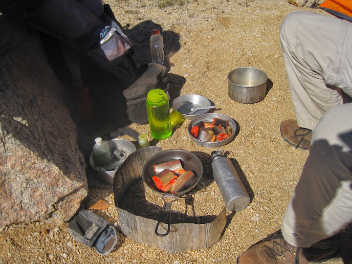
Ah! The first picture... Chunks of god's candy in the pans.
-
schmalz
- Topix Expert
- Posts: 588
- Joined: Fri May 07, 2010 9:18 am
- Experience: Level 4 Explorer
- Location: Altadena, CA
- Contact:
Re: 2014 Member Meet-up 7/22-7/27
You do not have the required permissions to view the files attached to this post.
http://CaliTrails.com" onclick="window.open(this.href);return false;
http://facebook.com/calitrails" onclick="window.open(this.href);return false;
http://facebook.com/calitrails" onclick="window.open(this.href);return false;
-
austex
- Topix Expert
- Posts: 553
- Joined: Mon May 21, 2012 11:51 am
- Experience: N/A
- Location: Austin, Texas
Re: 2014 Member Meet-up 7/22-7/27
-
Hobbes
- Topix Fanatic
- Posts: 1120
- Joined: Wed Apr 27, 2011 8:09 am
- Experience: N/A
- Location: The OC
TR: 2014 Member Meet-up 7/22-7/27
For anyone interested in visiting the area, here is the basic mileage breakdown from the Symmes trailhead:
TH->Shepherd pass 9.5 miles
Shepherd->Wales 9.5 miles via Rockwell pass & WLB
Rockwell pass is another 2.0 miles from Shepherd, and the first lakes in WLB are one more mile, so it's around 12.5 miles to WLB. I did it in one day after hiking 8:20 hours, or approx 1.5 mph.
If you stop @ WLB, then it's only 6.5 miles from there to Wales. While there is an old, partially maintained trail up Wallace creek, it's easy to traverse x-c up the watershed by simply staying between Wallace & Wales creeks, which are less than .5 mile apart. That's the way I proceeded, taking 4.1 hours or 1.6 mph.
To return, simply retrace your steps. I decided to hike the entire way back without stopping @ WLB, or 19 miles. It took me exactly 10 hrs (from 7am-5pm), for an avg of 1.9 mph.
To recap, 1/2 of the hike is via trail from the TH to Shepherd pass. Thereafter, it's all x-c to Rockwell, WLB & Wales. The x-c is very pleasant, with both the Wales/Wallace & WLB watersheds providing easy navigation by simply following the respective creeks up/down the meadows:
Wales creek - just follow the water (note Wallace creek right of shoulder):
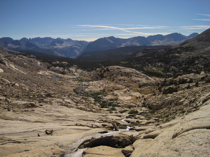
Wright creek - just follow the water:
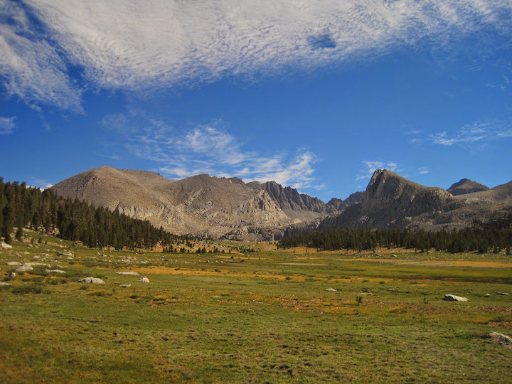
The entire area is really spectacular - thanx again to Mav for putting the trip together.
* Note - My base pack weight was 10lbs + 5lbs of food/water. So going in, my pack weighed 15 lbs, while leaving it was only 10lbs. As a result, trail times are essentially day hiking speeds.
TH->Shepherd pass 9.5 miles
Shepherd->Wales 9.5 miles via Rockwell pass & WLB
Rockwell pass is another 2.0 miles from Shepherd, and the first lakes in WLB are one more mile, so it's around 12.5 miles to WLB. I did it in one day after hiking 8:20 hours, or approx 1.5 mph.
If you stop @ WLB, then it's only 6.5 miles from there to Wales. While there is an old, partially maintained trail up Wallace creek, it's easy to traverse x-c up the watershed by simply staying between Wallace & Wales creeks, which are less than .5 mile apart. That's the way I proceeded, taking 4.1 hours or 1.6 mph.
To return, simply retrace your steps. I decided to hike the entire way back without stopping @ WLB, or 19 miles. It took me exactly 10 hrs (from 7am-5pm), for an avg of 1.9 mph.
To recap, 1/2 of the hike is via trail from the TH to Shepherd pass. Thereafter, it's all x-c to Rockwell, WLB & Wales. The x-c is very pleasant, with both the Wales/Wallace & WLB watersheds providing easy navigation by simply following the respective creeks up/down the meadows:
Wales creek - just follow the water (note Wallace creek right of shoulder):
Wright creek - just follow the water:
The entire area is really spectacular - thanx again to Mav for putting the trip together.
* Note - My base pack weight was 10lbs + 5lbs of food/water. So going in, my pack weighed 15 lbs, while leaving it was only 10lbs. As a result, trail times are essentially day hiking speeds.
Who is online
Users browsing this forum: No registered users and 36 guests