I'm the opposite. I don't mind a big fat (dry, level) log or a set of easy steps on (dry) rocks, but otherwise I prefer the certainty of wet feet to the possibility of injury if I lose footing trying to avoid getting my feet wet.no2haven wrote:Yeah, most of those creeks are easy boot crossings too...I just don't like getting wet, and will take the easy log over shallow water every time.
2011 BACKCOUNTRY CONDITIONS UPDATES
-
TehipiteTom

- Founding Member
- Posts: 953
- Joined: Thu Aug 24, 2006 8:42 am
- Experience: Level 4 Explorer
Re: Leavitt Meadows/Beartrap Lake
-
quentinc
- Topix Expert
- Posts: 890
- Joined: Tue Nov 01, 2005 10:28 pm
- Experience: N/A
- Location: Los Angeles
Re: 2011 BACKCOUNTRY CONDITIONS UPDATES
Thanks CG and Kathy. I guess my friends will just have to hike up to Wallace and make their own call. They're very cautious sorts, so I'm not worried about sending them that far. But Forester Pass will definitely be the Maginot Line!
-
AlmostThere
- Topix Addict
- Posts: 2724
- Joined: Wed Jun 24, 2009 4:38 pm
- Experience: Level 4 Explorer
Florence Lake, Muir Trail Ranch, Kaiser Pass
Trails are opening right and left. The trail between MTR and Florence is open, but in places under water, and in other places (meadows) muddy as heck.
The roads into Edison and Florence are free and clear - patchy snow continues to exist at about 9,000 feet along Kaiser Pass. Nearly everything below 9,000 in that area is melted out.
Piute Pass is still icy and snowy.
The roads into Edison and Florence are free and clear - patchy snow continues to exist at about 9,000 feet along Kaiser Pass. Nearly everything below 9,000 in that area is melted out.
Piute Pass is still icy and snowy.
-
Packtofish
- Topix Acquainted
- Posts: 54
- Joined: Thu Jul 27, 2006 4:44 pm
- Experience: N/A
- Location: San Luis Obispo, CA
Re: 2011 BACKCOUNTRY CONDITIONS UPDATES
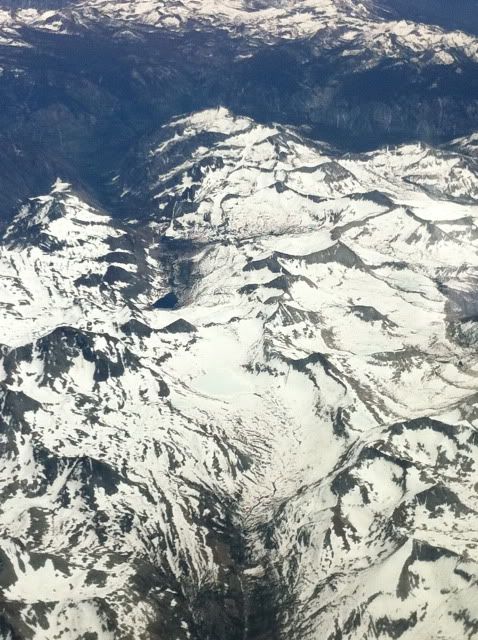
Not so much a trip report, but I flew across the Sierra today and passed over Evolution Valley and had a good look at the area. From what I saw, Wanda lake and the Muir Pass area was nearly solid snow cover. Saffire was maybe 20% clear. The Darwin Lakes looked like they had nearly solid cover. I also passed over east to west, just north of Mammoth and saw that Thousand Island and Garnet were still snow covered, but there was signs of water showing from the air.
Didn't have my good camera, but I snapped a few cruddy iPhone pics.
Reds Meadow
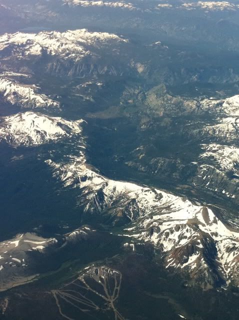
Thousand Island Lake
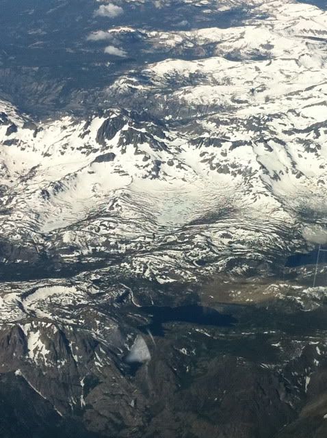
Southern Yosemite and the Clarke Range
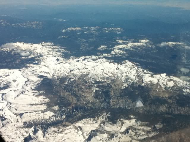
Goddard Canyon
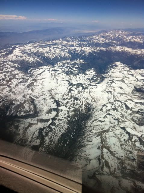
Muir Pass and Wanda under snow
Apologize for the crummy pics....
Didn't have my good camera, but I snapped a few cruddy iPhone pics.
Reds Meadow
Thousand Island Lake
Southern Yosemite and the Clarke Range
Goddard Canyon
Muir Pass and Wanda under snow
Apologize for the crummy pics....
-
gary c.
- Topix Fanatic
- Posts: 1479
- Joined: Tue Jan 24, 2006 4:56 pm
- Experience: N/A
- Location: Lancaster, CA
Re: 2011 BACKCOUNTRY CONDITIONS UPDATES
Pictures look great to me. Things are looking much better than a few weeks ago. Thanks for posting them.
"On this proud and beautiful mountain we have lived hours of fraternal, warm and exalting nobility. Here for a few days we have ceased to be slaves and have really been men. It is hard to return to servitude."
-- Lionel Terray
-- Lionel Terray
-
papercup
- Topix Acquainted
- Posts: 69
- Joined: Wed Jun 08, 2011 4:40 pm
- Experience: Level 4 Explorer
- Location: Los Angeles
Cottonwood Pass, Miter Basin, Soldier Lakes 7/2-7/9
Spent a week (7/2 - 7/9) in the southern sierra via Cottonwood Pass. Conditions were excellent. There's still some snow floating around, but most trails are largely snow-free, and those that retain cover are easily navigable. Climbed Langley and Cirque, explored the Siberian Outpost, Whitney Meadows, Miter Basin, Upper and Lower Soldier Lakes. All are doable. A few spots are made more complicated by the snow. Rock Creek was not a problem. A few of the higher lakes are still partially frozen. Some of the lower lakes and streams were full of trout.
Also climbed Army Pass and New Army Pass from the West. It's easy enough to get to the top, but both passes remain snow-covered from the East and should not be climbed without proper equipment. Poles and boots won't cut it.
If anybody would like more information on any of these spots, I'd be happy to provide what I can.
It's still fairly quiet out there. Except for the PCT, we rarely saw more than one or two groups a day. Some days passed in complete isolation. Bumped into a solo hiker on Langley, and spied one photographer from the distance while viewing Miter Basin from the Major General, but otherwise saw nobody while off trail. I don't know if this is just a quiet area or what, but the isolation was nice. Even Chicken Spring Lake, which I expected to be quite busy, had only one other tent during the night we spent there.
Last edited by papercup on Tue Jul 12, 2011 10:30 am, edited 2 times in total.
-
mschnaidt

- Topix Regular
- Posts: 233
- Joined: Fri Jan 28, 2011 5:58 pm
- Experience: Level 4 Explorer
- Location: Cameron Park, CA
Re: 2011 BACKCOUNTRY CONDITIONS UPDATES
Hey Papercup,
Thanks for posting. Do you have any photos of Army Pass? I'm hoping to head through the pass without crampons and ice axe two weeks from today. Any feedback would be appreciated.
M
Thanks for posting. Do you have any photos of Army Pass? I'm hoping to head through the pass without crampons and ice axe two weeks from today. Any feedback would be appreciated.
M
-
hikerchick395
- Topix Regular
- Posts: 174
- Joined: Fri Sep 11, 2009 4:41 pm
- Experience: N/A
- Location: Round Valley, Bishop
Re: 2011 BACKCOUNTRY CONDITIONS UPDATES
After hiking up to Piute Pass last Friday, I was curious about Kearsarge Pass, so hiked up there yesterday. (The SEKI NPS site claimed that the Kearsarge Basin was still snowbound on their July 8 report.) Not many cars at the trailhead. Snow was icy early, but softened up nicely. It ended up that there was more snow on the eastside...the trail to the west was clear and the lakes were ice free (except a tiny bit on the western most Kearsarge Lake.)
-
papercup
- Topix Acquainted
- Posts: 69
- Joined: Wed Jun 08, 2011 4:40 pm
- Experience: Level 4 Explorer
- Location: Los Angeles
Re: 2011 BACKCOUNTRY CONDITIONS UPDATES
One of my companions definitely has some photos of Army and New Army. I'll post them when I manage to get ahold of them, which should hopefully be within the next day or two.
-
Sierra Maclure

- Topix Regular
- Posts: 137
- Joined: Fri Oct 26, 2007 8:25 am
- Experience: N/A
- Location: Bay Area
- Contact:
Cathedral Lakes 7/8-7/10
Sunrise Lks Thead at Tenaya Lk outlet is down to about 30 in. deep. Navigable non-postholing snow up to the Clds R. Junction.
Cath. Lkes trail clear til just before the Toe. Creek into Lower C is brisk. Lower C. meadow a knee deep swamp. Upper Cath. Lk 80% frozen. Lots of snow. Some dirt to camp on.
Lower Cathedral Lake 7-10-11:

Upper Cathedral Lake 7-10-11:

Cath. Lkes trail clear til just before the Toe. Creek into Lower C is brisk. Lower C. meadow a knee deep swamp. Upper Cath. Lk 80% frozen. Lots of snow. Some dirt to camp on.
Lower Cathedral Lake 7-10-11:
Upper Cathedral Lake 7-10-11:
Last edited by maverick on Tue Jul 12, 2011 9:25 am, edited 1 time in total.
Reason: subject
Reason: subject
In the Spirit of the Wilderness, SM
http://pages.sbcglobal.net/sierramaclure/
http://sierramaclure.smugmug.com/
http://pages.sbcglobal.net/sierramaclure/
http://sierramaclure.smugmug.com/
Who is online
Users browsing this forum: No registered users and 137 guests