2016 Backcountry Conditions Reports
-
robow8

- Topix Regular
- Posts: 343
- Joined: Wed Nov 13, 2013 5:17 pm
- Experience: N/A
Lodgepole to Twin Lakes 5/28 - 5/30
Silliman Creek below knee wade. A little patchy snow below Cahoon Gap, mostly snow on the North side to Clover Creek. Patchy snow and lots of snowmelt on the trail th Twin Lakes, becoming all snow just below the lakes. Some bare patches around the lakes, which are partially frozen. 3 feet of snow in the shade.
-
ksenn

- Topix Novice
- Posts: 19
- Joined: Thu May 24, 2012 9:13 am
- Experience: N/A
5/29: Desolation Wilderness- Lake Sylvia
Route taken: Lyon's Creek Trail to Lake Sylvia
Difficult section encountered: Trail is a running stream or swamp if not covered in snow. Patchy snow below 7400ft increasing to 100% coverage around 7800ft. Lake is mostly frozen over, starting to melt around the edges. Lyons creek is high and fast. Postholed a few times up to my thighs.
Special equipment needed/used: None, but may want waterproof footwear if adverse to getting wet feet.
You do not have the required permissions to view the files attached to this post.
-
oliverlu

- Topix Novice
- Posts: 7
- Joined: Fri May 10, 2013 1:46 pm
- Experience: N/A
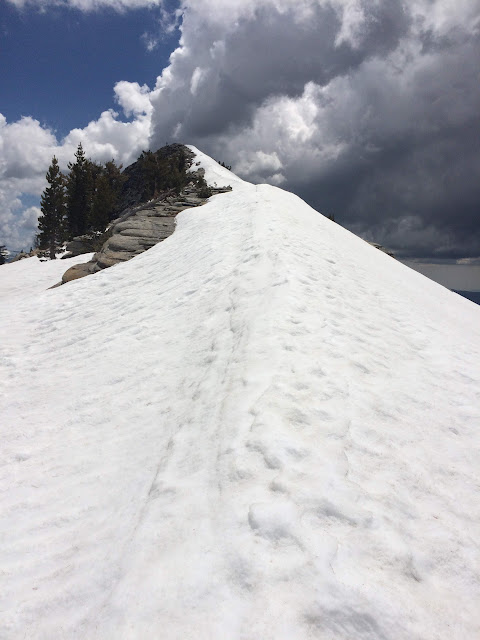
Clouds Rest 5/26 - 5/30
Approached from North, patches of snow on south facing fire-burned area beginning at 8700. Full consolidated coverage at 9,000. 3-4' consolidated knife ridge of snow covering the granite steps leading towards summit at 9,900'. South approach mostly clear with sporadic patches of snow.
-
dougieb
- Topix Regular
- Posts: 127
- Joined: Tue May 27, 2014 9:10 pm
- Experience: Level 4 Explorer
Chicken Spring Lake 5/28 / Shepherd Pass Trail 5/29
5/28 Hiked from horseshoe meadows to Chicken Spring Lake and then just above the lake to look west. There was very little snow on the trail until Chicken Spring Lake which was mainly frozen. About a 50/50 spread between dry and snow covered areas. Looking to the west, golden trout meadows down there had very little to no snow from what I could see.
5/29 Hiked along Symmes Creek on the Shepherd's Pass trail and it was beautiful. The water is flowing pretty well but it is all below knee high and easy to cross. There was no snow for us but we only went to about 7000 feet so duh. Snow looked like it was peppered around 10,500 in that drainage.
5/29 Hiked along Symmes Creek on the Shepherd's Pass trail and it was beautiful. The water is flowing pretty well but it is all below knee high and easy to cross. There was no snow for us but we only went to about 7000 feet so duh. Snow looked like it was peppered around 10,500 in that drainage.
Last edited by maverick on Wed Jun 01, 2016 6:24 pm, edited 1 time in total.
Reason: subject matter
Reason: subject matter
-
snevill
- Topix Novice
- Posts: 16
- Joined: Thu Apr 12, 2012 11:44 am
- Experience: N/A
Sabrina Basin 5-26 through 5-29
Hiked out of Lake Sabrina to Blue Lake. The trail was under snow in a number of places and there were a number of spots with precarious snow crossings. Blue Lake was mostly frozen and the surrounding areas had about 50% snow coverage. The trail to Dingleberry Lake required a detour around a steep snow crossing. We didn't venture beyond Dingleberry due to the conditions (and incoming weather).
-
ExploreABitMore
- Topix Regular
- Posts: 168
- Joined: Thu Jan 11, 2007 2:38 pm
- Experience: Level 4 Explorer
- Location: Ridgecrest, CA
- Contact:
Re: 2016 Backcountry Conditions Reports
Looks like a forest fire in the Kennedy Meadows area just started up. Didn't notice it around lunch time, came out to go home and there it was. Looks to be just a little north of Sawtooth Peak.
Sierra Nevada, Mojave Desert, Night Sky Photography: http://www.evanthomasphoto.com/
-
Snowtrout
- Topix Regular
- Posts: 296
- Joined: Mon Feb 18, 2013 10:06 pm
- Experience: Level 3 Backpacker
- Location: Fresno, CA
Summit Lake 5/27-5/30
Summit Lake TR: 5/27-5/30
Hiked out of Shake Camp on Friday evening and got about 3 miles in before making camp. Saturday: saw some snow around 7500', lots of snow drifts around 8000-8500 on East, West & North facing slopes. At 9000', lots of deeper snow banks. At 9400', snow was 2-6' deep depending on location. Summit lake was 75% iced over with only around the shore areas open water. Tried to make it to Maggie lakes but with the trail junction sign for windy gap only 1' above the snow, we returned back to Summit lake and found the only camp spot near the lake that was not wet. Sunday: like partially froze back up but quickly melted by 9am. Too many hikers up there (+20) to stay, so we headed back down to the Tule River. Snow was melting fast on the way down and with these hot temps, the snow is going to go fast.
Hiked out of Shake Camp on Friday evening and got about 3 miles in before making camp. Saturday: saw some snow around 7500', lots of snow drifts around 8000-8500 on East, West & North facing slopes. At 9000', lots of deeper snow banks. At 9400', snow was 2-6' deep depending on location. Summit lake was 75% iced over with only around the shore areas open water. Tried to make it to Maggie lakes but with the trail junction sign for windy gap only 1' above the snow, we returned back to Summit lake and found the only camp spot near the lake that was not wet. Sunday: like partially froze back up but quickly melted by 9am. Too many hikers up there (+20) to stay, so we headed back down to the Tule River. Snow was melting fast on the way down and with these hot temps, the snow is going to go fast.
Last edited by maverick on Thu Jun 02, 2016 10:03 am, edited 1 time in total.
Reason: subject matter
Reason: subject matter
-
Shawn
- Topix Fanatic
- Posts: 1061
- Joined: Sat Nov 12, 2005 9:56 pm
- Experience: Level 4 Explorer
Treasure Lakes June 3, 2016
Route taken:
Did a quick day hike to Treasure Lakes out of South Lake above Bishop. The Treasure Lakes "trail" was in dismal condition, the upper third of my route was ad hoc due to snow.
Difficult section encountered:
Due to very warm temps, it was a post-hole horror show on the upper elevation on approach to the lakes.
Special equipment needed/used:
Hiking poles helped with the soft snow / post-hole extraction tools.
Possible alternative routes:
I just made my own path when I encountered continuous snow. It is melting fast so it shouldn't be an issue for much longer.
Note: On my way down I encountered three fisherman that lost the trail and seemed, um, significantly delayed in a forested area no where near the trail. I gave them an extra map I had and provided some instructions to get them back on course. If you are not comfortable navigating off trail, and the trail unexpectedly disappears due to snow, perhaps the best choice is to turn around and try another day.
You do not have the required permissions to view the files attached to this post.
-
Wandering Daisy
- Topix Docent
- Posts: 6689
- Joined: Sun Jan 24, 2010 8:19 pm
- Experience: N/A
- Location: Fair Oaks CA (Sacramento area)
- Contact:
Emigrant-N Yosemite, May 30-June 4
Road to Shingle Springs TH is in good shape.
Kibby Ridge trail, in better shape than 2009, but new deadfall and overgrown sections. Several wet bogs, but mostly quite dry.
North facing slope down to the unnamed lakes west of Mecur Peak melting snow- some 3-foot drifts, LOTS of water, every topographic indentation a pond.
Little or no snow on route: Styx Pass - Boundary Lake - Little Bear Lake - Spotted Fawn Lake- Flora Lake - Barrett Lakes - Many Island Lake.
Day-hike to Inferno Lakes - pretty solid snow on north facing slopes, no snow on south facing slopes.
A majority of the watershed of these lakes have already melted, so lakes are high and full, but creeks are reasonable- wade to cross but not deep.
What amazed me, was how warm the water was in the lakes and small creeks.
On the way out I dropped down to Lord Meadow, Cherry Creek is HUGE! and still icy cold.
All week it was HOT! The snow is going fast at this elevation (7000-8000 feet). A few snow banks below Styx Pass were totally gone on the way out. I doubt it got below 50-60 degrees at night.
Wildflowers just beginning to bloom, the best is yet to come. Willows getting buds.
The road up to Cherry Lake really shows the devastation from the Rim Fire. Among all the burn, this year's wildflowers are in full bloom.
-
Vaca Russ

- Topix Expert
- Posts: 809
- Joined: Mon Aug 16, 2010 3:12 pm
- Experience: Level 4 Explorer
- Location: The Nut Tree
Deso High Country June 2-3
I hiked into and camped at the Dicks Lake outlet. The next morning I climbed Dicks Peak via the north face.
Northern Deso is completely snow free.
Susie is half ice free, Half Moon is starting to clear.
Pyramid, Jacks and Agassiz still hold plenty of snow.
Dicks and Fontanillis are frozen solid...The Velma's are clear.
Last year WD asked about the pass above and between Island and Clyde...here is this year's photo:
I wouldn't recommend trying to cross Dicks Pass without an ice ax and crampons.
Please see a full report here:
viewtopic.php?f=14&t=14460
Thanks,
-Russ
You do not have the required permissions to view the files attached to this post.
Last edited by Vaca Russ on Mon Jun 06, 2016 7:41 am, edited 1 time in total.
"...Or have you only comfort, and the lust for comfort, that stealthy thing that enters the house a guest, and then becomes a host and then a master?"
Kahil Gibran.
Kahil Gibran.
Who is online
Users browsing this forum: No registered users and 87 guests