Page 1 of 1
What % of the Sierra is High Sierra?
Posted: Tue Feb 13, 2018 4:08 pm
by limpingcrab
Talking with a friend of mine who prefers to exclusively hike and backpack in the high country, which led me to my usual comment that, "if you only go to the High Sierra you're missing over half of what it has to offer."
Now we're wondering about the accuracy of the guestimate?
I don't have access to GIS anymore but I know there are a lot of map addicts on here, any chance someone knows or could figure it out?
Guessing the parameters, maybe say anything above 500 ft is Sierra and anything above 9000' is High Sierra? But, on the east side the base of the mountains are a lot higher, and the High Sierra elevation varies with lattitude so that complicates it.
I'm bored at work and can't find the answer online, but it's another factoid that I think would be interesting to know.
Thanks!
Re: What % of the Sierra is High Sierra?
Posted: Tue Feb 13, 2018 8:56 pm
by AlmostThere
My response runs along the lines of "how can you miss something you don't really enjoy that much?"
I will never miss the gnats down in the oaks... I like manzanita to look at, but not to walk through. Not going to miss all the sap caked around my pant cuffs and shoes from the mountain misery. Not going to miss the heat.
I know that you mean "miss" in a different sense of the word. But I've never been a conformist.
Re: What % of the Sierra is High Sierra?
Posted: Wed Feb 14, 2018 6:36 pm
by wildhiker
Here's a rough estimate for you.
I used the "measure area" tool in Caltopo to measure a polygon that approximately outlines the entire Sierra Nevada, base on the Google satellite imagery. It totalled 14 million acres. You can see that polygon here:
https://caltopo.com/m/NJ2G
Then I figured a rough proxy for the "High Sierra" would be the total of Wilderness Areas in the Sierra. I got the list and acreage of each from
http://www.wilderness.net and added it up: 3,896,169 acres. That would be nearly 28% of the Sierra Nevada polygon that I measured.
It is a sad fact that almost all designated Wilderness is "on the rocks" due to competition from commercial utilization at the lower elevations. Still, the designated Wilderness includes some mid-elevation forest and even some foothills (for example,in Sequoia National Park). On the other hand, not all high country is in designated Wilderness. Based on my previous study of this, I'd estimate there is about 400,000 acres of additional roadless lands in the Sierra Nevada not designated as Wilderness, much of which is high country. So, we might adjust the proxy measurement (Wilderness areas to total) down a bit, but not too much.
My rough estimate is therefore that 25% of the entire Sierra Nevada is high country.
-Phil
Re: What % of the Sierra is High Sierra?
Posted: Wed Feb 14, 2018 9:58 pm
by dave54
When does a hill become a mountain? When does a creek become a river?
'High' is a subjective term. Above timber line? When pine forests transition to true fir? White Fir versus Red Fir?
Re: What % of the Sierra is High Sierra?
Posted: Thu Feb 15, 2018 10:58 am
by TahoeJeff
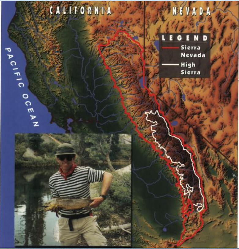
Here is an image I lifted from "High Sierra Fly Fishing" by Billy VanLoek depicting High Sierra vs. Sierra.
Re: What % of the Sierra is High Sierra?
Posted: Thu Feb 15, 2018 7:03 pm
by limpingcrab
My response runs along the lines of "how can you miss something you don't really enjoy that much?"
You sound like my friend! To each their own. I'm a biodiversity nerd and the lower elevations have the high sierra beat by a long shot. Plus I like rivers and caves and such. It's all different and it's all great!
My rough estimate is therefore that 25% of the entire Sierra Nevada is high country.
Reasoning looks reasonable to me! I guess my friend is missing 75% of what the Sierra has to offer

When does a hill become a mountain? When does a creek become a river?
'High' is a subjective term. Above timber line? When pine forests transition to true fir? White Fir versus Red Fir?
She doesn't say it this way, but from her preferences I'd say krummholz tree land and up. She was not happy when one of our backpack trips followed part of the MF Kings. "I can see bushes and trees like this from my car"
Here is an image I lifted from "High Sierra Fly Fishing" by Billy VanLoek depicting High Sierra vs. Sierra.
Looks like a broad approximation with a lot of points to argue, but still seems like about 1/3 or less of the total area.
Re: What % of the Sierra is High Sierra?
Posted: Thu Apr 05, 2018 1:15 am
by Harlen
Thanks for a great topic limpingcrab. The question "what is the High Sierra?" has provided my friends and me with a lot of fun debate over the years. We are considering the question purely on an individual, qualitative basis, and the personal views vary a lot. I'd be interested in hearing other folk's feelings on this topic. So what feels like the High Sierra to you?
For myself, I get a distinct "sea of peaks" feeling when hiking or climbing in the area from the Kings-Kern Divide, north to the Goddard Divide, and including the Main divide up to about Mount Mendel. To the north and south of that part of the Sierra there are some stunningly beautiful, rugged, and perhaps even more remote areas- such as the west side of the Ritter Range, and to the south- the east side of the Kaweah Peaks Ridge, but I don't get quite the same deep in the mountains feeling. Others have drawn a much larger High Sierra polygon, from the the Muir Crest, across the Kern to the high mountains of the Great Western Divide, then all the way up to the headwaters of the Toulumne- including Tower Peak, and over to the Sawtooth Ridge. That larger area has great appeal to me too, as it so expands the "High Sierra."
In a parallel light, a couple of the Rocky Mountain Ranges, namely the Wind River Range of Wyoming, and the San Juan's in Colorado have a much more expansive, deep mountains feeling compared to climbing peaks in say, the Sangres, from which one looks down on flat valleys, roads, and towns on either side- however, the Sangres have some of the wildest, best looking individual mountains in all the Rockies!
My friends and I are just talking about each of our personal High Sierra-feeling area, nothing to do with a quantitative study. It generally spins off into talk and stories about our favorite divides, ridges, or sub-ranges. Dreaming about the Sierra Nevada is the next best thing to being there.
Re: What % of the Sierra is High Sierra?
Posted: Thu Apr 05, 2018 2:04 pm
by Tom_H
TahoeJeff wrote:Here is an image I lifted from "High Sierra Fly Fishing" by Billy VanLoek depicting High Sierra vs. Sierra.
Having lived at Tahoe for a couple of years, as you have for many, I have to object to the Nevada side of the lake being omitted from the "Sierra" designation. I have some fond memories of hiking, alpine, and nordic skiing in all of that area.
Re: What % of the Sierra is High Sierra?
Posted: Thu Apr 05, 2018 4:36 pm
by TahoeJeff
Tom_H wrote: Nevada side of the lake being omitted from the "Sierra" designation
Yeah, I didn't think geologic features honored state boundaries...
Re: What % of the Sierra is High Sierra?
Posted: Fri Apr 06, 2018 6:15 am
by giantbrookie
TahoeJeff wrote:Tom_H wrote: Nevada side of the lake being omitted from the "Sierra" designation
Yeah, I didn't think geologic features honored state boundaries...
There is also the problem of the recreational/geographic definition of the Sierran range not coinciding with the geologic definition, and for that matter, geologists not agreeing with each other on said definition.
For example, the most consistent definition is to make the eastern boundary of the range the set of big faults on the eastern side. However, from Tahoe northward most definitions of the mountain range from a physiological standpoint include ranges east of this set of faults: the Carson Range E of Tahoe is one example. It is usually included in folks' definition of Sierra. The Diamond Mtns E of Mohawk Valley/Quincy is also usually included in definitions of the Sierra. Yet, when you think about it, including those in the definition of the Sierra is pretty much the equivalent of including the White-Inyo Mtns, too, hence it is inconsistent with the geology (ie the position of eastern frontal faults).
As for "High" this is much more subjective. The "traditional" split probably came from the old (Voge) Climbers Guide where in the northern boundary of "High" was Tower Peak on the N border of Yosemite and the south border was Cirque Peak.