Page 1 of 1
Goddard Creek Rock Slide
Posted: Tue Jan 22, 2013 11:57 pm
by RoguePhotonic
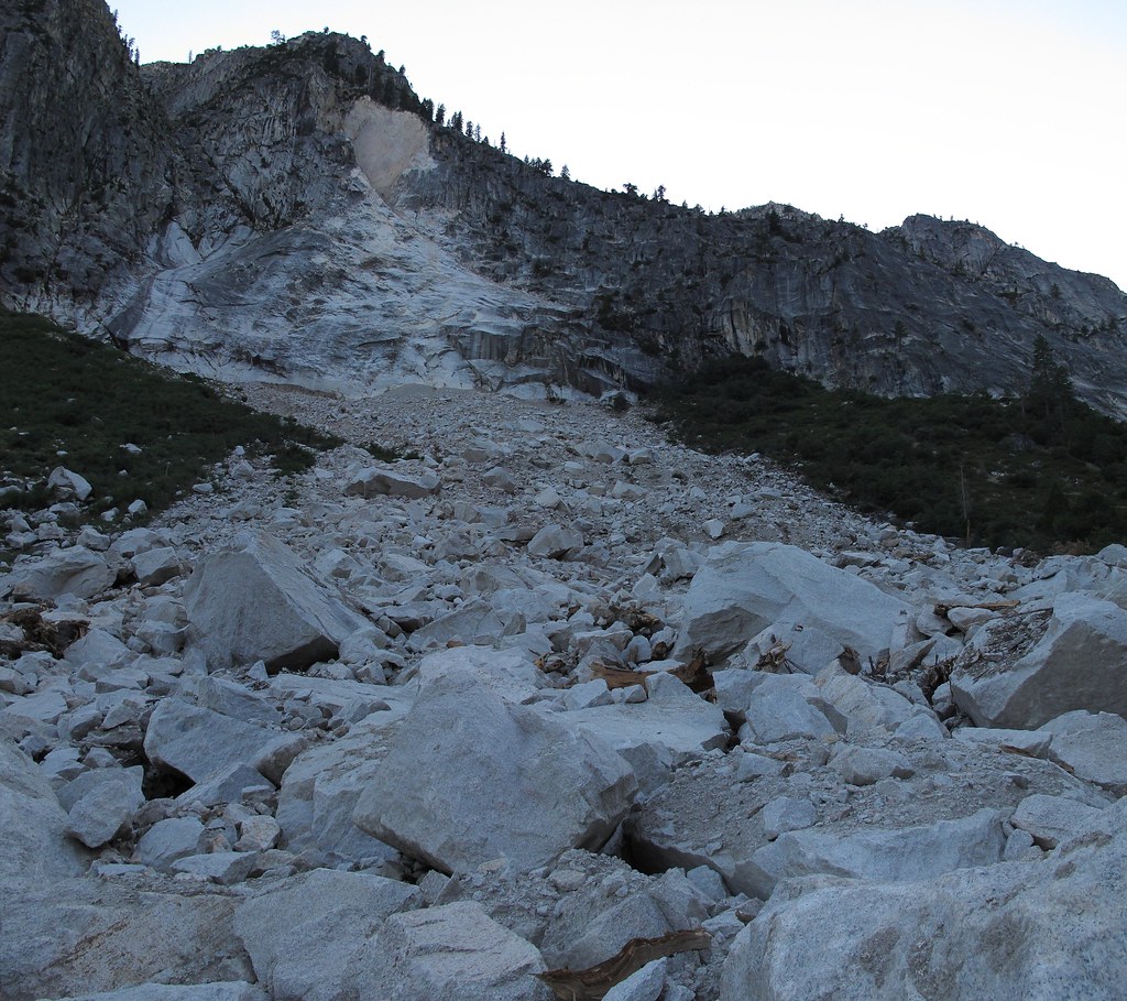
While flying around Google Earth I noticed the photos have updated to include the rock slide that happened in 2011 on Goddard Creek. Some of you may remember my trip report of climbing across it.
https://maps.google.com/maps?hl=en&ll=3 ... 2&t=h&z=17" onclick="window.open(this.href);return false;
An epic slide for sure. Wish I could have seen it happen!
Another side note is I notice a great deal of brush has been washed away from the banks all the way to where I could not go any further and was forced to the West side of the creek. Judging by all the scattered trees an avalanche did some brush work. Too bad it stopped short of where I was forced to turn back and cross the creek.
Re: Goddard Creek Rock Slide
Posted: Wed Jan 23, 2013 7:41 am
by Carne_DelMuerto
I watched a NG show the other night called "Secret Yosemite." (Hardly anything secret about it, but anyway...) It had a section about the 1996 Happy Isles rock fall and the air blast it created. Did you see any sign of a massive air blast?
Yes, it would have been amazing to witness that. From a distance. A very safe distance.
Re: Goddard Creek Rock Slide
Posted: Wed Jan 23, 2013 12:36 pm
by RoguePhotonic
I'm sure this fall produced a large pyroclastic flow when it occured but when I was there I was too miserable to be annalyzing the whole area for the effects of it. I just wanted to get to a place to camp before it got dark.
Re: Goddard Creek Rock Slide
Posted: Wed Jan 30, 2013 9:03 pm
by Troutdog 59
WOW!!! Now that's impressive Rouge. Your pic is fantastic, but the aerial really shows the scale of the slide/rock fall. Thanks for sharing the pic!!
Re: Goddard Creek Rock Slide
Posted: Wed Jan 30, 2013 10:18 pm
by RoguePhotonic
Yeah the photos don't even come close to showing just how large it is or how big some of the rocks are in it.
Re: Goddard Creek Rock Slide
Posted: Thu Jan 31, 2013 9:59 pm
by Herm
Hi Rogue;
Nice photo - I wonder how much that would change any topo maps?!?!?
Just a small correction - a pyroclastic flow is a volcanic feature, very different from a debris flow. My inner geologist had to speak out. But that rock fall/debris flow had to cause some kind of wind blast.
Cheers,
Herm
Re: Goddard Creek Rock Slide
Posted: Thu Jan 31, 2013 11:22 pm
by RoguePhotonic
You would know better then me but I thought a pyroclastic flow was used to describe any cloud of that nature including landslides and buildings brought down by controlled demolition?
Re: Goddard Creek Rock Slide
Posted: Fri Feb 01, 2013 4:53 am
by The Other Tom
RoguePhotonic wrote:You would know better then me but I thought a pyroclastic flow was used to describe any cloud of that nature including landslides and buildings brought down by controlled demolition?
I'm not a geologist but I did spend last night at a Holiday Inn

From Wikipedia:
A pyroclastic flow (also known scientifically as a pyroclastic density current[1]) is a fast-moving current of hot gas and rock (collectively known as tephra), which reaches speeds moving away from a volcano of up to 700 km/h (450 mph).[2] The gas can reach temperatures of about 1,000 °C (1,830 °F). Pyroclastic flows normally hug the ground and travel downhill, or spread laterally under gravity. Their speed depends upon the density of the current, the volcanic output rate, and the gradient of the slope. They are a common and devastating result of certain explosive volcanic eruptions.
Re: Goddard Creek Rock Slide
Posted: Fri Feb 01, 2013 7:12 am
by RoguePhotonic
Well it's certainly less dramatic to say the rock slide produced a nice dust cloud.
Re: Goddard Creek Rock Slide
Posted: Thu Feb 07, 2013 9:22 pm
by Bluewater
We were talking about your trip report when we saw that rock slide from Windy Ridge last summer.
goddard canyon.JPG
BTW, the east side of the White Divide leading up to Tunemah Lake looks like fun, possibly next season.