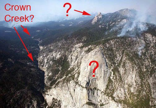
ID dome near Tehipite Valley?

Topics covering photography and videography of the flora, fauna and landscape of the Sierra Nevada mountains. Show off your talent. Post your photos and videos here!
Post Reply
User avatar
ericZ
Topix Regular
Posts: 161
Joined: Sun Jul 29, 2007 10:41 am
Experience: Level 2 Backpacker
Location: fresno, ca.

ID dome near Tehipite Valley?

Post by ericZ »

hello everyone. i was hoping someone here could help me identify the dome in the center of this photograph. the finger/crag/point above and beyond it would be helpful too. the view is looking north, perhaps NNW. tehipite valley i believe is out of the frame to the right as well as the middle fork kings. the drainage on the left of the frame i believe is crown creek. i'm thinking the dome in the center is kettle dome but would like those more knowledgeable to confirm or suggest another identity.

this was taken friday and shows part of the tehipite fire in kings canyon.

thanks for any help.

eric
fresno, ca.

Image
User avatar
Buck Forester
Founding Member
Posts: 452
Joined: Mon Oct 31, 2005 1:38 pm
Experience: N/A
Location: Lincoln, CA (Sacramento area)
Contact:

Re: ID dome near Tehipite Valley?

Post by Buck Forester »

Hery Eric... I've never seen the Tehipite area from this aerial perspective (cool that you got to fly in a chopper over this place!), but I'm 100% sure the foreground dome is Tehipite, and 99% sure the secondary dome is Kettle Dome. How recent was this pic? Looks like the fire just keeps on keepin' on.
It's all about the WILDERNESS!!!

http://www.flickr.com/photos/buckforester/page9/
User avatar
ericZ
Topix Regular
Posts: 161
Joined: Sun Jul 29, 2007 10:41 am
Experience: Level 2 Backpacker
Location: fresno, ca.

Re: ID dome near Tehipite Valley?

Post by ericZ »

thanks buck. the photo was taken on friday, sept 26. early afternoon. the pilots and pr person identified it as tehipite dome but from other views/photos, the top looks very different. from tehipite dome photos, it seems the dome is more spire-like than this shot i have. i regret now i did not request we circle again for me to shoot exactly what was beneath us and tehipite valley itself. we flew up the valley a bit more then swung west and went toward the smoke you see in the distance, then circled back towards the confluence and back towards the hidden fire.

just to make sure, i've included question marks for the landmarks in question. the top one i thought might be castle peak...

eric
fresno, ca.

Image
User avatar
Buck Forester
Founding Member
Posts: 452
Joined: Mon Oct 31, 2005 1:38 pm
Experience: N/A
Location: Lincoln, CA (Sacramento area)
Contact:

Re: ID dome near Tehipite Valley?

Post by Buck Forester »

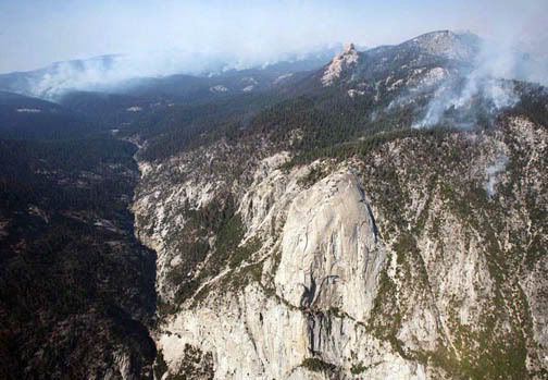
The foreground "?" dome is certainly Tehipite Dome. As I mentioned I haven't seen it from this perspective/angle, but when you're on the rim of Tehipite Valley right before the big descent, Tehipte Dome does not appear dome-like at all. It just looks like a big granite cliff. It's an odd optical illusion that the dome appears so different from eye-level or above vs. from the valley floor. From the valley floor Tehipite Dome is very domed looking, from eye-leve it appears nearly level with the rim... which is almost is... looking at photos from the backside (this photo, if it shows up, is from climber.org and shows the backside of Tehipite Dome from the rim) http://www.climber.org/TripReports/imag ... -route.jpg it doesn't appear very domey. From the valley floor it looks like this http://gallery.photo.net/photo/837322-lg.jpg I have a few shots from the rim but I'm not exactly sure where I have them online, too many photo folders, ha!

And that's definitely the Crown Creek drainage. Silver Spray Falls is just to the left of Tehipite Dome... you had to have been flying pretty much over Tehipite Valley to get this perspective. It probably just looked like a wide space along the M.F. Kings River, because Tehipite Valley is just this side of your pic of Tehipite Dome.

In the background "?" I can almost say for certain that is Kettle Dome, 99% sure... in fact check out Google Earth and type in "Tehipite Dome" and follow the direction of the pic and there lies Kettle Dome.

Next time you fly over this place, let me know, ha!
It's all about the WILDERNESS!!!

http://www.flickr.com/photos/buckforester/page9/
User avatar
maverick
Forums Moderator
Forums Moderator
Posts: 11835
Joined: Thu Apr 06, 2006 5:54 pm
Experience: Level 4 Explorer

Re: ID dome near Tehipite Valley?

Post by maverick »

Yeap that's Kettle Dome and Rodgers Creek(Silver Spray Falls).
From the photo it looks like the smoke in the back is in Crown Valley area
I hope there isn't to much damage to the area.
No wonder CG was suffering from the smoke up in Ionian Basin and seeing the
smoke recently on his trip in the Minarets area.
Glad I postponed my trip to the area with it still looking like that.
Post Reply

Who is online

Users browsing this forum: No registered users and 85 guests