Page 1 of 1
Need New Plans due to Snow - Public transportation?
Posted: Wed Jun 03, 2015 9:36 am
by dgalp
Hi everyone,
My plan was to hike the High Sierra Trail starting June 6 to Whitney, meet up with a friend hiking the PCT in the Kern Canyon, and continue with him along the JMT to Yosemite.
Then I revised the plan to exit at Whitney, since I thought the passes along the JMT looked impassable.
Now the trip reports from Kaweah Gap and Whitney Crest are making me think that this is not gonna happen. (I have no snow experience.) Clearly I made the wrong bet on the low snow winter.
Now I am looking for alternate hiking plans, since I´m in California for the next 3 weeks.
I don´t have my own car, so I´m looking for not-snowed-in long trails I can get to via public transportation, without getting my friends to drive me all over. I can get to the Tahoe Rim trail on the bus, but I think a lot is still snowed in. Yosemite is accessible, and I can go in the middle of the week to get a day-of permit.
Does anybody have any other ideas, in the Sierra or throughout California?
All of your knowledge and trip reports have been very helpful throughout my planning, and I´d appreciate your thoughts now.
Re: Need New Plans due to Snow - Public transportation?
Posted: Wed Jun 03, 2015 10:35 am
by Dave_Ayers
Since you can get to Tahoe, the Tahoe to Yosemite PCT section comes to mind. I think it's ~132 mi from Echo Lake to Tuolumne Meadows and ~190 from hwy 80 to Tuolumne Mdws where you can connect with bus routes.
If you want to fill the whole 3 weeks, you'd have options to extend the trip on one of the many Yosemite trails. One way to extend the route would be to hike the Grand Canyon of the T to White Wolf and connecting to YARTs or the Hiker's Bus there. Or you could head to Isberg Pass and do a loop back to either TM or Yose Valley via the high and low trails. You could get resupply at Sonora Pass Resupply and/or the TM post office to keep the load down.
Nearly all the PCT north of Yosemite is below ~9,000 feet except the St. Mary's Pass area which reaches ~10,500 so I'd think your risk of difficult snow walking is low (barring a big storm).
Re: Need New Plans due to Snow - Public transportation?
Posted: Wed Jun 03, 2015 12:21 pm
by maverick
Hi Dgalp,
Welcome to HST! Please read:
viewtopic.php?f=1&t=4205
When you have time, please write up an intro:
viewtopic.php?f=1&t=9329
Re: Need New Plans due to Snow - Public transportation?
Posted: Wed Jun 03, 2015 1:05 pm
by Hobbes
I would stick with your original plan. The snow level last week (5/30) was around 11.5-12k; more significantly, it's melting very rapidly. To top it off, there's a small squall coming that is supposed to rain, not snow, which will further diminish any traces over the passes. And, if you needed any more convincing, the weather beginning Sunday is supposed to be positively epic for the next 6-7 days:
http://www.wunderground.com/weather-for ... 46.1.99999
Here's what Kearsarge pass (11,760) looked like on 5/28:
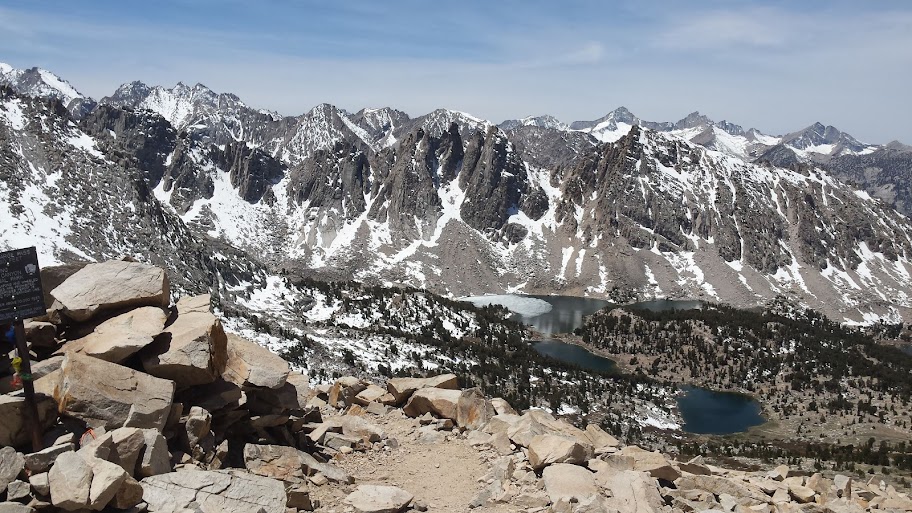
I had day hiked up to the top to help get a little more acclimatized before setting out the next day for Whitney. I ended up hanging out for 2 hours because I wanted to maximize my time at elevation, the weather was perfect, and it was fun talking to PCTers. They were having no problems* crossing Forester last week (albeit postholing in the afternoon, but everyone got through without incident), so it will be even easier if you hit it in another 7-10 days.
Schmalz remarked how dry the Sierra looked to the west from Whitney, especially the GWD & Kaweahs. Maybe he can post some photos if he comes across this thread.
* It's also important to consider what type of experience/clothing/equipment the avg PCT hiker has for the Sierra: absolutely -0-. They come over in the afternoon in micro running shorts & trail runners. Now, if you have long pants, boots/heavier shoes, and time the passes appropriately ie the morning, then it's difficult to imagine why you too shouldn't have any problems.
Re: Need New Plans due to Snow - Public transportation?
Posted: Wed Jun 03, 2015 1:11 pm
by LightRanger
I tend to agree with the post above to keep the plan. Recent snowfall is unconsolidated and fell on almost no base in most places in the Southern Sierra, so you're not going to see much of the typical troublesome-in-the-morning-without-crampons isothermal snowpack that usually occurs in the Sierra in spring.
Dave_Ayers wrote:Nearly all the PCT north of Yosemite is below ~9,000 feet except the St. Mary's Pass area which reaches ~10,500 so I'd think your risk of difficult snow walking is low (barring a big storm).
Don't disagree with most of that, but Sonora Pass area definitely has snow above 9K. I have buddies who skied the Leavitt/Deadman area last weekend. Not sure if it would necessarily be problematic, but it's there. See this instagram post from yesterday:
http://websta.me/p/998938874426710426_496480533
Probably more snow there than anywhere else in the range, except maybe the Ritter/Banner and Conness/North Peak areas.
Re: Need New Plans due to Snow - Public transportation?
Posted: Wed Jun 03, 2015 1:18 pm
by Hobbes
Agreed on the Conness/Donohue region - looking north from Whitney, it clearly had the most snow. (Where is Schmalz? He took lots of photos.)
Here's a shot of Iceberg (12,600) on 5/30 from around 12,900:

Re: Need New Plans due to Snow - Public transportation?
Posted: Wed Jun 03, 2015 2:56 pm
by seanr
I've been closely following Sierra conditions all spring and agree with Hobbes and LightRanger. Start in the south.
Regarding Sonora Pass, the snow is usually a little different each year/season/week/day and things will melt fast, but the route between Sonora Pass and Leavitt Peak (the area south of the pass) has two steep (north and northeast facing) slopes that hold snow/ice late into the season. It is not a great place for initiation to snow travel if nervous and ill equipped. I was there late May of last year and found deep snow and icy sections almost roadside. I had fun glissading!
Re: Need New Plans due to Snow - Public transportation?
Posted: Wed Jun 03, 2015 4:57 pm
by dgalp
Thanks to everyone for the replies!
I´m definitely surprised (but heartened) that many people are recommending going ahead with the hike.
The Sequoia NP trail conditions page reports Kaweah Gap as ¨Very difficult to find trail, Extremely icy. Crampons needed¨ on 5/27. Does anyone know if there´s been significant snow melt over 10,000ft in the last week? They didn´t have updated information when I called today.
Re: Need New Plans due to Snow - Public transportation?
Posted: Wed Jun 03, 2015 6:37 pm
by AlmostThere
I would go and if you run into snow on Kaweah Gap, it is easy enough to turn around.
A friend of mine just went out toward Hamilton and may make it to Precipice. He's already been up to Hamilton this season since the last snow. Just that much would be a nice trip, and with a couple days extra you could do a side trip up to the top of Elizabeth Pass (views are splendid) or down to Redwood Meadows and back then out to Crescent Meadow.