Page 1 of 2
Nat Geo/Trails Illustrated Maps...Milage markers seem wrong?
Posted: Tue Jul 17, 2012 1:24 pm
by madeintahoe
I am wondering if the milage markers on these maps may be wrong? A hike I did yesterday shows the milage on this map to be 3.9 miles RT...The sign post have it to be 5 miles RT...and on most TR I have read have the hike to be at 6.5 miles RT.
I am wondring if this is a miss print on just this trail on the map or what...and if anyone else has seen a differnce in the milage with these maps? The map I have is the Carson/Iceberg..Emigrant & Mokelumne Wilderness
Re: Nat Geo/Trails Illustrated Maps...Milage markers seem wrong?
Posted: Tue Jul 17, 2012 4:14 pm
by AlmostThere
The mileage is more accurate on Harrison maps. The Nat geo maps are often wrong, I've found (the hard way....).
Re: Nat Geo/Trails Illustrated Maps...Milage markers seem wrong?
Posted: Tue Jul 17, 2012 4:28 pm
by Tollermom
Which trail were you on? I'd like to check my various maps and trail books.
Re: Nat Geo/Trails Illustrated Maps...Milage markers seem wrong?
Posted: Tue Jul 17, 2012 4:46 pm
by madeintahoe
AlmostThere..Thank you...Yes Harrison maps are better I think..Glad to know it is just not me seeing this.
Tollermom..We were on the Winnemucca/Round Top Lakes loop hike..starts at Woods Lake, up to Winnamucca, up to Round Top Lake and back down past the Lost Cabin Mine back to Woods Lake.
Thank you both!
Re: Nat Geo/Trails Illustrated Maps...Milage markers seem wrong?
Posted: Wed Jul 18, 2012 8:27 pm
by Tollermom
Hmmm. My Nat Geographic map #807 Carson Iceberg, Emigrant and Mokelumne has it at 3.9 miles. Ski Tours in the Sierra Nevada by Marcus Libkind has it at 5 miles..but this book is copyright 1985 and way before GPS. The Tahoe Sierra -A natural history guide by Jeffrey Schaeffer has it at 4.4 miles as does Favorite Tahoe Hikes by Frederick Page Johnston. Afoot and Afield by Mike White has it at 4.8 miles. Somewhere in my collection I have another map (which right now escapes me). Will have to find it. I must say the Nat Geo seems pretty short and that's a bummer because I have two Nat Geo maps and I originally bought them for their mileage markers and lovely colors and the plasticity. Rats.

Re: Nat Geo/Trails Illustrated Maps...Milage markers seem wrong?
Posted: Wed Jul 18, 2012 8:30 pm
by balzaccom
The NatGeo maps not only have mileage errors....they also have such heavy shading that it is hard to read the contour lines in some areas.
Not my favorite map publisher.
Re: Nat Geo/Trails Illustrated Maps...Milage markers seem wrong?
Posted: Fri Jul 20, 2012 3:27 am
by AfterSeven
After Decades of Hiking, I can confirm that for most maps:
1.0 mile on the map =
1.5 miles actually traveled by my legs =
2.0 miles that my brain thinks I traveled =
3.0 miles I tell people I traveled years later
seems to me that on most maps which are two dimensional such a mileage shortage would be easily explained by the failure to take into account lateral movement in the trail lost by virtue of a 1:24000 ratio that simply cant be accurately reflected on a map...also, ppl at natgeo would need a special algorithm to account for vertical travel up/down which can't be accounted for on a 2D map...on its best day, such an algorithm, if it existed, would be very arbitrary, incomplete, inaccurate and hampered by issues of scale...although it would probably get you closer to the truth.
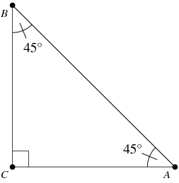
So you walk up a hill from A to B and that distance is 10 miles....the map is only showing the distance from A to C... so on an imaginary 10 mile uphill hike the mapmaker would log that in at approximately 7.27 miles on the 2D Map (A to C)...and BOOM you just lost 2.73 Miles! Mind you the loss in distance inherent to 2D calculations is the most Conservative possible outcome....It assumes the trail doesn't go side to side at all between A and C and assumes that the trail would not go up and down and then up again between A and C ...all of which you would expect to see on a normal trail and all of which would add Even MORE distance to the paltry NatGeo 2 Dimensional Calculations!
Hope that helps.
Re: Nat Geo/Trails Illustrated Maps...Milage markers seem wrong?
Posted: Fri Jul 20, 2012 6:50 am
by balzaccom
Most mileage these days is done with a hiker and a GPS unit, measuring exact distance hiked.
But you still have to copy that data onto the map.
Re: Nat Geo/Trails Illustrated Maps...Milage markers seem wrong?
Posted: Fri Jul 20, 2012 6:45 pm
by rlown
It's kind of funny. OR was proud of his very colorful Nat Geo map, which showed a camping closure on the N side of Lillian and the names were somewhat misspelled to his dismay. We watched about a dozen people move into camps on the N side, so evidently no closure. Even the Clover Meadow ranger had no camp restrictions at that lake.
Re: Nat Geo/Trails Illustrated Maps...Milage markers seem wrong?
Posted: Sat Jul 21, 2012 7:13 am
by balzaccom
Lillian was closed to camping two years ago. It is now open--at least according to the Ranger we spoke to last summer