TR: Ansel Adams Wilderness Aug. 23rd - 26th
Posted: Wed Aug 28, 2013 4:56 pm
Sacramento to Mammoth Lakes:
I went to work Thursday morning with an extra bounce in my step because I knew that I would soon be enjoying some Sierra beauty. I watched the clock like a teenager on the last day of school. When the big hand finally fell on the "3" I immediately shut down and bolted for home. I took care of some last minute packing details while I waited for my friend to show up and as soon as he did, I said my goodbyes to the family, loaded up the Subie, and we hit the road eastbound.
The drive there was pretty uneventful except for the stretch of highway up and over Monitor Pass. We were the only car on the road at this late hour which made it eerily dark and quiet. At the top of the pass the car was completely engulfed in thick swirling smoke while headlight illuminated ash whizzed by the windshield like I was Luke Skywalker navigating the universe in hyperspace. As I type this I'm still not sure all of the blood has returned to my steering wheel clutched white knuckles.
Upon arriving at Mammoth Lakes, we picked up our permit from the night box, grabbed a couple of Mammoth IPA tall boys from the Chevron, and checked into the luxurious Motel 6.
Agnew Meadows to Thousand Island Lake:
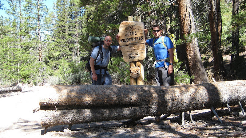
After only a couple of hours of sleep, we gathered up our gear, checked out, and searched for food. Thanks to a nice couple in the parking lot, we were steered toward the Good Life Cafe where we enjoyed a tasty breakfast. Stomachs now full, like the bear canisters in our packs, we drove up to the main lodge to then take the shuttle to the true beginning of the trip: Agnew Meadows Trail Head.
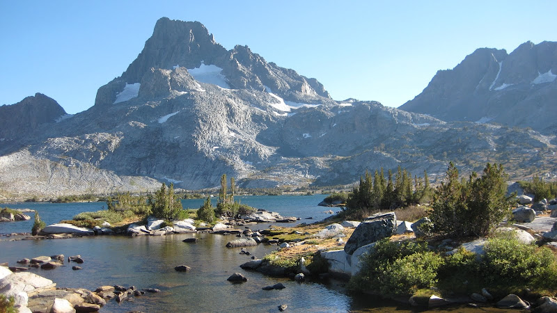
We took the High Trail, which is also the PCT, north to Thousand Island Lake. You start with a series of moderate switchbacks halfway up the river valley wall and then mostly contour it till you reach the headwaters of the river below.

After reaching the lake and picking up our jaws from the amazing views, we continued west along the north shore past many others finally setting up on the far west end of the lake near a stream that follows the draw up towards North Glacier Pass, which is where we were headed the next morning.


The winds began to pick up as the afternoon progressed and forced us into the tent before we would have liked, but we still enjoyed the scene with a bit of Scotch to pass the time before bed.
Thousand Island Lake to Lake Catherine and back:
While we were looking for a good camp site the day before, a couple coming down the mountain stopped to chat with us for a bit. They shared their pics from Lake Catherine, which solidified our decision to day hike it today. They also mentioned that they were skunked in their search for the Rettenbacher grave site. I mentioned that from reading trip reports I knew it was in the area, but I forgot to do the research before the trip. He handed me a crumpled up piece of paper that had a brief description of the site location along with a grainy black and white photo and said, "good luck."
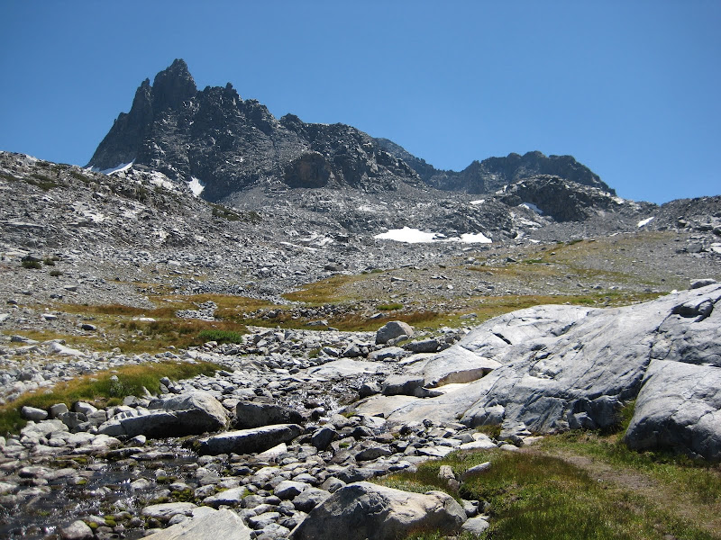
After a quick breakfast of oatmeal and coffee, we gathered lunch and a few essentials, and made our way up the valley towards North Glacier Pass. While following the obvious use trail that parallels the stream up towards the pass, we kept eyeing the photo of the grave site to see if we could get the topography to match up.

Just as we started to scratch our heads and think, "well, it has to be right here," we spotted the shine of the copper-ish plaque.


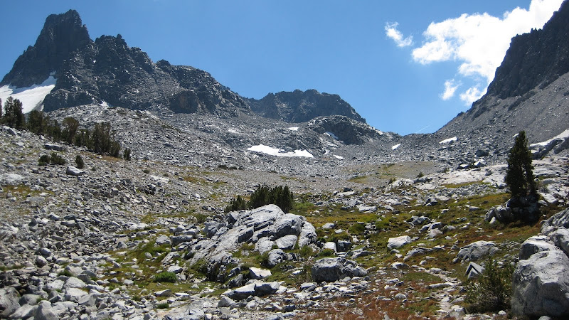
After a brief moment of silence for the ones before us, we set focus on the pass. We pretty much took a straight line to it rather than the correct route and paid for it with at least an extra half hour of scrambling along the scree.

We reached the false pass while another hiker was coming down. We spoke briefly about the route up the pass, the cold wind, and if we had heard his hoot and hollering while on the summit of Banner.

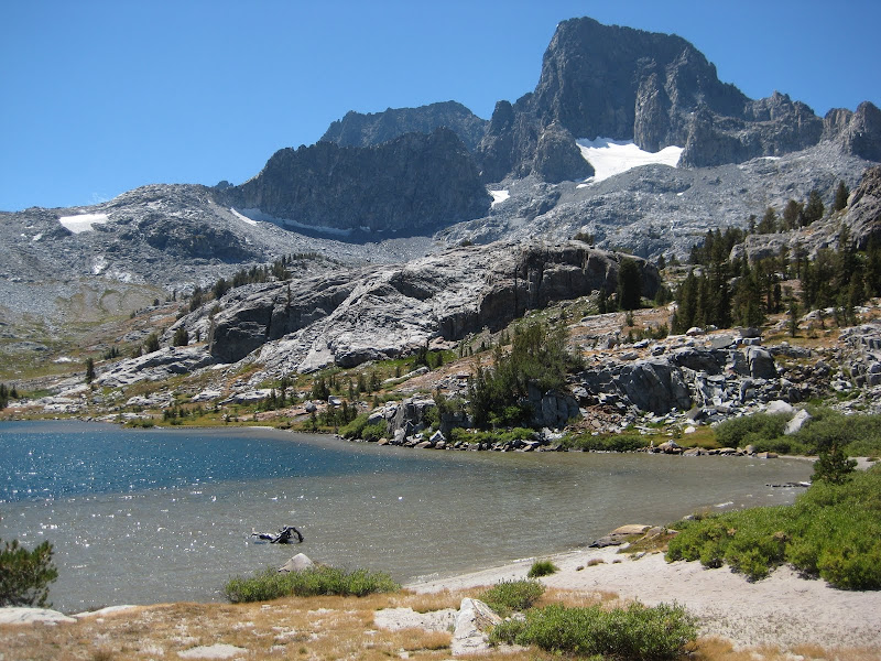
Once over to the other side, we were blown away by the prettiest color of blue I think I've ever seen. The wind died down just long enough for us to grab some water and eat lunch on the shore before making our way back to base camp.


Thousand Island Lake to Garnet Lake:
After a little R&R at camp, we packed up and circumvented the west shore of Thousand Island Lake and made our way south over Garnet Pass. Really easy, especially since we've been psyching ourselves up for Whitebark Pass, which was going to be tomorrow's route. More on that later.

We headed east past the tarns and streams that drop into Garnet Lake. This area is absolutely serine and beautiful. It will make the most manliest men start describing the scene beyond the primary colors. I'm pretty sure I heard my friend say "Caribbean pastel green" and I mentioned something about a "cerulean blue." If you asked me now I'd have no idea how to describe those colors, but at that moment it all made sense.


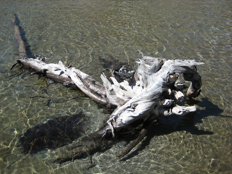
Once we reached the shores of Garnet Lake, we stopped near the first peninsula we came across and set up the tent a bit above and away from the lake in hopes of being sheltered from the wind. With quite a bit of daylight left, I took off my shoes and explored around the sandy shores and waded out into the beautiful lake. The sand felt great on my feet and the cold waters numbed any pain away.
Similar to the night before, after sunset the wind really started to pick up and forced us into the tent where we again enjoyed some Scotch and played a couple of rounds of dominoes. I woke up several times during the night to the sound of wind ripping past the peaks, through the basin, and slamming into the tent.
Garnet Lake to Middle Fork San Joaquin River:
While shaking the sand out of my stuff that was blown into the tent from the night before, my friend noted the clouds that were starting to build against Banner.


The wind was still pretty strong at this point and after discussing our planned route over Whitebark Pass, we decided to chicken out. In retrospect, I wish we would have went over it, but it will be there for next time. On the plus side, it really opened up our morning "schedule" so we just lounged around and enjoyed what Garnet Lake had to offer.

My friend decided to fish for a bit despite the winds and was rewarded with three nice trout (c&r). I explored the sandy shores barefoot again and pretty much walked the sand bar all the way to the far west inlet of the lake and back. My feet felt good!

We discussed routes over lunch and decided to make the scramble down the outlet of Garnet to the Middle Fork San Joaquin River. We packed up and hit the trail heading east along Garnet Lake's shore. After a bit we came across quite a few other camps, which up until this point was rare. We realized that we hadn't seen another person since ascending up towards Lake Catherine the day before. Boy were things about to change.
A small backpacking tent here, turned into an entire circus tent over there. There were people camped out everywhere! We literally had to walk around a huge 8-man tent that was set up dead center on the trail. They had a huge blue poly tarp shaped into a circular wall with a solar shower seen above. I've never seen anything like it. Needless to say, we pushed on fast to get out of there. I highly recommend staying on the far west ends of Thousand Island and Garnet if you'd like any chance of privacy.

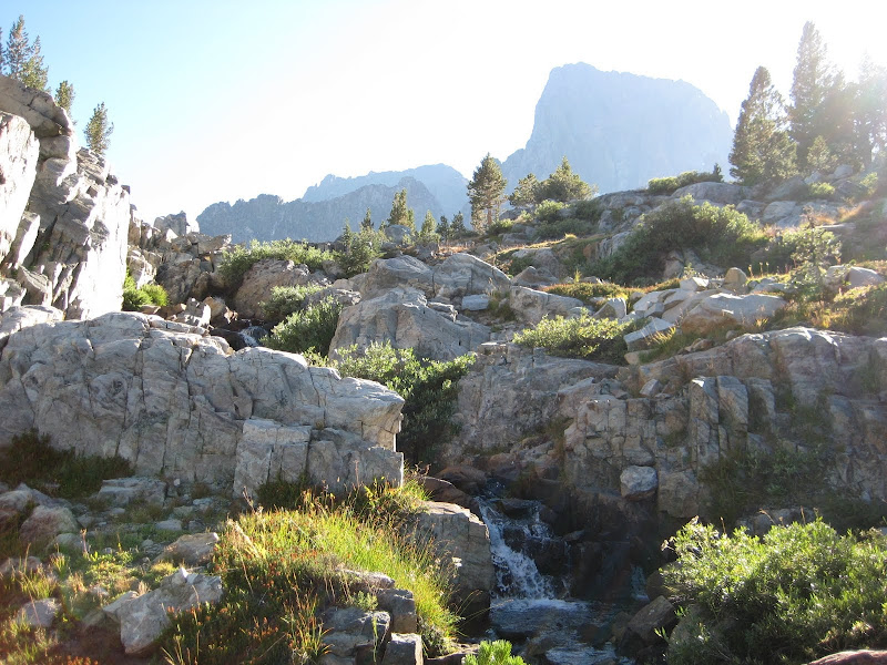
We crossed the bridge over the outlet and then made an immediate left to follow the water fall down to the river below. The wind was so strong at this point, that while crossing the bridge my entire bottom half became wet from lake spray!


Somehow we missed any resemblance of the trail and just stuck to the slick rocks on the side of the falls, which was quickly turning into a healthy class 3+ down climb. We decided to head into the forest a bit to see if we could find the "use" trail, which turned out to be very well defined and traveled - doh. We happily made the rest of our way down to the river on the trail. A nice flat outcropping that overlooked a small waterfall in the river appeared so we decided to setup there for the night. For once, the wind subsided and we were able to enjoy an evening sitting around watching stars. The final ounces of Scotch were consumed while discussing how if everyone was a backpacker the world would be perfect. I'm pretty sure I was asleep before I finished zipping up my sleeping bag for the night.
Middle Fork San Joaquin River to Agnew Meadows:
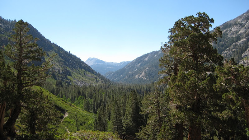
We woke up early, ate breakfast, packed up, and hit the trail. We crossed the Middle Fork of the San Joaquin River and followed the River Trail back down to Agnew Meadows. We saw quite a few deer along this stretch and except for one pissed off buck, they all seemed a bit too tame.


Just as we reached the road to wait for the shuttle bus back to town, it arrived - woohoo! Our driver, Keith, recommended the pies at John's Pizza Works, which is adjoined to the Outlaw Saloon, conveniently located on main street our way out. He also fills us in on the stats of the Rim Fire. Keith tells no lies and we devoured a delicious supreme pizza while chatting to the bar tender about mountain life and making it financially on seasonal work. Cold beers washed the final crumbs from our grubby faces and all was good in the universe.
The drive back sucked. As soon as we passed Mono Lake the smoke began and didn't end until Kyburz (about 25 miles west of Lake Tahoe). I call my wife to let her know that I'm alive and well. Also, to cancel our plans in S. Tahoe for Labor Day weekend and to start looking up options on the coast. Gotta love living in California!
I went to work Thursday morning with an extra bounce in my step because I knew that I would soon be enjoying some Sierra beauty. I watched the clock like a teenager on the last day of school. When the big hand finally fell on the "3" I immediately shut down and bolted for home. I took care of some last minute packing details while I waited for my friend to show up and as soon as he did, I said my goodbyes to the family, loaded up the Subie, and we hit the road eastbound.
The drive there was pretty uneventful except for the stretch of highway up and over Monitor Pass. We were the only car on the road at this late hour which made it eerily dark and quiet. At the top of the pass the car was completely engulfed in thick swirling smoke while headlight illuminated ash whizzed by the windshield like I was Luke Skywalker navigating the universe in hyperspace. As I type this I'm still not sure all of the blood has returned to my steering wheel clutched white knuckles.
Upon arriving at Mammoth Lakes, we picked up our permit from the night box, grabbed a couple of Mammoth IPA tall boys from the Chevron, and checked into the luxurious Motel 6.
Agnew Meadows to Thousand Island Lake:
After only a couple of hours of sleep, we gathered up our gear, checked out, and searched for food. Thanks to a nice couple in the parking lot, we were steered toward the Good Life Cafe where we enjoyed a tasty breakfast. Stomachs now full, like the bear canisters in our packs, we drove up to the main lodge to then take the shuttle to the true beginning of the trip: Agnew Meadows Trail Head.
We took the High Trail, which is also the PCT, north to Thousand Island Lake. You start with a series of moderate switchbacks halfway up the river valley wall and then mostly contour it till you reach the headwaters of the river below.
After reaching the lake and picking up our jaws from the amazing views, we continued west along the north shore past many others finally setting up on the far west end of the lake near a stream that follows the draw up towards North Glacier Pass, which is where we were headed the next morning.
The winds began to pick up as the afternoon progressed and forced us into the tent before we would have liked, but we still enjoyed the scene with a bit of Scotch to pass the time before bed.
Thousand Island Lake to Lake Catherine and back:
While we were looking for a good camp site the day before, a couple coming down the mountain stopped to chat with us for a bit. They shared their pics from Lake Catherine, which solidified our decision to day hike it today. They also mentioned that they were skunked in their search for the Rettenbacher grave site. I mentioned that from reading trip reports I knew it was in the area, but I forgot to do the research before the trip. He handed me a crumpled up piece of paper that had a brief description of the site location along with a grainy black and white photo and said, "good luck."
After a quick breakfast of oatmeal and coffee, we gathered lunch and a few essentials, and made our way up the valley towards North Glacier Pass. While following the obvious use trail that parallels the stream up towards the pass, we kept eyeing the photo of the grave site to see if we could get the topography to match up.
Just as we started to scratch our heads and think, "well, it has to be right here," we spotted the shine of the copper-ish plaque.
After a brief moment of silence for the ones before us, we set focus on the pass. We pretty much took a straight line to it rather than the correct route and paid for it with at least an extra half hour of scrambling along the scree.
We reached the false pass while another hiker was coming down. We spoke briefly about the route up the pass, the cold wind, and if we had heard his hoot and hollering while on the summit of Banner.
Once over to the other side, we were blown away by the prettiest color of blue I think I've ever seen. The wind died down just long enough for us to grab some water and eat lunch on the shore before making our way back to base camp.
Thousand Island Lake to Garnet Lake:
After a little R&R at camp, we packed up and circumvented the west shore of Thousand Island Lake and made our way south over Garnet Pass. Really easy, especially since we've been psyching ourselves up for Whitebark Pass, which was going to be tomorrow's route. More on that later.
We headed east past the tarns and streams that drop into Garnet Lake. This area is absolutely serine and beautiful. It will make the most manliest men start describing the scene beyond the primary colors. I'm pretty sure I heard my friend say "Caribbean pastel green" and I mentioned something about a "cerulean blue." If you asked me now I'd have no idea how to describe those colors, but at that moment it all made sense.
Once we reached the shores of Garnet Lake, we stopped near the first peninsula we came across and set up the tent a bit above and away from the lake in hopes of being sheltered from the wind. With quite a bit of daylight left, I took off my shoes and explored around the sandy shores and waded out into the beautiful lake. The sand felt great on my feet and the cold waters numbed any pain away.
Similar to the night before, after sunset the wind really started to pick up and forced us into the tent where we again enjoyed some Scotch and played a couple of rounds of dominoes. I woke up several times during the night to the sound of wind ripping past the peaks, through the basin, and slamming into the tent.
Garnet Lake to Middle Fork San Joaquin River:
While shaking the sand out of my stuff that was blown into the tent from the night before, my friend noted the clouds that were starting to build against Banner.
The wind was still pretty strong at this point and after discussing our planned route over Whitebark Pass, we decided to chicken out. In retrospect, I wish we would have went over it, but it will be there for next time. On the plus side, it really opened up our morning "schedule" so we just lounged around and enjoyed what Garnet Lake had to offer.
My friend decided to fish for a bit despite the winds and was rewarded with three nice trout (c&r). I explored the sandy shores barefoot again and pretty much walked the sand bar all the way to the far west inlet of the lake and back. My feet felt good!
We discussed routes over lunch and decided to make the scramble down the outlet of Garnet to the Middle Fork San Joaquin River. We packed up and hit the trail heading east along Garnet Lake's shore. After a bit we came across quite a few other camps, which up until this point was rare. We realized that we hadn't seen another person since ascending up towards Lake Catherine the day before. Boy were things about to change.
A small backpacking tent here, turned into an entire circus tent over there. There were people camped out everywhere! We literally had to walk around a huge 8-man tent that was set up dead center on the trail. They had a huge blue poly tarp shaped into a circular wall with a solar shower seen above. I've never seen anything like it. Needless to say, we pushed on fast to get out of there. I highly recommend staying on the far west ends of Thousand Island and Garnet if you'd like any chance of privacy.
We crossed the bridge over the outlet and then made an immediate left to follow the water fall down to the river below. The wind was so strong at this point, that while crossing the bridge my entire bottom half became wet from lake spray!
Somehow we missed any resemblance of the trail and just stuck to the slick rocks on the side of the falls, which was quickly turning into a healthy class 3+ down climb. We decided to head into the forest a bit to see if we could find the "use" trail, which turned out to be very well defined and traveled - doh. We happily made the rest of our way down to the river on the trail. A nice flat outcropping that overlooked a small waterfall in the river appeared so we decided to setup there for the night. For once, the wind subsided and we were able to enjoy an evening sitting around watching stars. The final ounces of Scotch were consumed while discussing how if everyone was a backpacker the world would be perfect. I'm pretty sure I was asleep before I finished zipping up my sleeping bag for the night.
Middle Fork San Joaquin River to Agnew Meadows:
We woke up early, ate breakfast, packed up, and hit the trail. We crossed the Middle Fork of the San Joaquin River and followed the River Trail back down to Agnew Meadows. We saw quite a few deer along this stretch and except for one pissed off buck, they all seemed a bit too tame.
Just as we reached the road to wait for the shuttle bus back to town, it arrived - woohoo! Our driver, Keith, recommended the pies at John's Pizza Works, which is adjoined to the Outlaw Saloon, conveniently located on main street our way out. He also fills us in on the stats of the Rim Fire.
The drive back sucked. As soon as we passed Mono Lake the smoke began and didn't end until Kyburz (about 25 miles west of Lake Tahoe). I call my wife to let her know that I'm alive and well. Also, to cancel our plans in S. Tahoe for Labor Day weekend and to start looking up options on the coast. Gotta love living in California!