Page 2 of 3
Re: TR 5/20-23: Edyth Redux, Kendrick Creek Falls
Posted: Tue May 28, 2013 12:30 pm
by fourputt
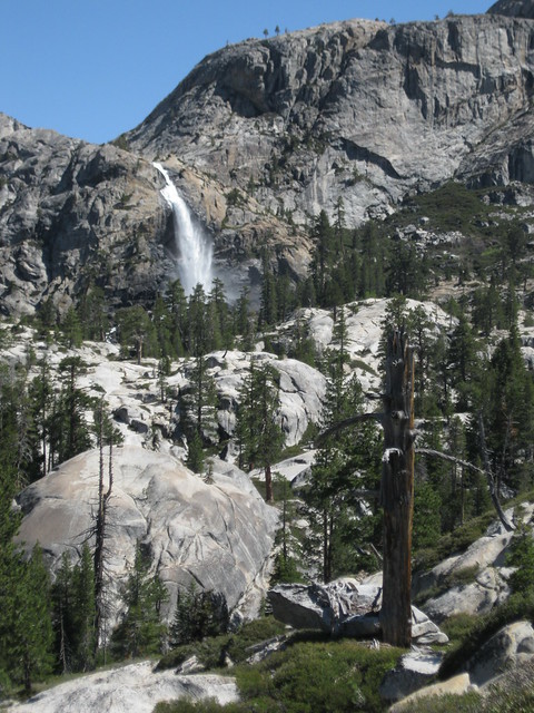
I saw signs of an old campsite at the falls. Getting over them to the right should be easy tho I have no knowlege of what happens after that.
Re: TR 5/20-23: Edyth Redux, Kendrick Creek Falls
Posted: Tue May 28, 2013 1:08 pm
by DoyleWDonehoo
RoguePhotonic wrote:Cool to see some pics of what I should expect next week. Hopefully I can climb up the falls to the right.
Either there or at about 600 meters to the NE. Bring bug spray.
Take lots of pictures of Big Island Lake, Bear Lake and especially Peninsula Lake.

Re: TR 5/20-23: Edyth Redux, Kendrick Creek Falls
Posted: Tue May 28, 2013 5:23 pm
by RoguePhotonic
My only concern above the falls is the satellite view shows smooth granite on both sides of the river but it's impossible to tell if it is steep or an easy stroll. Either way as Doyle said there looks like a place to get up to the NE.
I don't plan on visiting those lakes though. I'm going straight up Kendrick Creek to Twin Lakes.
Re: TR 5/20-23: Edyth Redux, Kendrick Creek Falls
Posted: Tue May 28, 2013 10:02 pm
by tomba
Here are some photos a
trip a 10 days earlier that could help you (click to see larger version):
IMG_1640-kendrick-creek-falls-zoom-lofi.jpeg
IMG_1656-kendrick-creek-falls-crop-lofi.jpeg
Re: TR 5/20-23: Edyth Redux, Kendrick Creek Falls
Posted: Wed May 29, 2013 8:27 am
by Scouter9
I love getting to see and read about areas well-outside my little box of familiarity in the eastern Sierra. Great photos, too! Thanks for taking the time to post it all.
Re: TR 5/20-23: Edyth Redux, Kendrick Creek Falls
Posted: Thu May 30, 2013 2:14 pm
by murphtron
@fourputt, is this the route you followed from the trail across Frog to Edyth lake? I'm guessing the pic of the large tarn is the one in the map at elevation 7385. Correct or no?
Mapped Route to Edyth
Cheers.
mtron
Re: TR 5/20-23: Edyth Redux, Kendrick Creek Falls
Posted: Thu May 30, 2013 2:46 pm
by giantbrookie
murphtron wrote:@fourputt, is this the route you followed from the trail across Frog to Edyth lake? I'm guessing the pic of the large tarn is the one in the map at elevation 7385. Correct or no?
Cheers.
mtron
I don't know fourputt's exact route but I can tell you that the route you've shown on the topo is almost on the best route except that I would put it precisely through the low point in the ridge and then descend, dodging various thickets of brush and small cliffs. I did this coming out of Edyth on a loop trip that dropped into L 5680+ (lake downstream of Edyth) from the vicinity of Laurel L. I've also been to Edyth following the north side of Kendrick after dropping in from Cherry Lake (much, much harder with horrific brush).
Re: TR 5/20-23: Edyth Redux, Kendrick Creek Falls
Posted: Thu May 30, 2013 4:05 pm
by murphtron
giantbrookie wrote:
I don't know fourputt's exact route but I can tell you that the route you've shown on the topo is almost on the best route except that I would put it precisely through the low point in the ridge and then descend, dodging various thickets of brush and small cliffs.
@giantbrookie, to which ridge to you refer? The low point from Moraine Ridge @7800ft down to the tarn? Or the ridge NW of Frog Creek (just SW of the route shown on the topo)?
I remember years ago you gave me advice on getting to Edyth via Cherry Creek. We bailed while looking down upon Edyth from Nance Peak after scrambling up from Spotted Fawn.
All of a sudden I'm considering bailing on my planned loop route to follow the W Fork of Cherry Creek north to Hyatt Lake and then down the main fork of Cherry and back out. Instead going to Edyth Lake up Kendrick to Upper Peninsula Lake and then somehow scrambling out to Otter Lake and a forced march back down the PCT to the trailhead @ Hetch Hetchy. Hmmm... not sure I can do that in 4 days.
Re: TR 5/20-23: Edyth Redux, Kendrick Creek Falls
Posted: Thu May 30, 2013 4:46 pm
by fourputt
Forgive my mspaint skills, but pretty close. I actually found ducks passing the largest tarn on the NE slipping between two knobs to Frog Creek.
I included the ducked route above the campsite with my visit to the inlet in green. The crack heading NE from the inlet was easier going than coming down but required getting by some cliffs from the shore.

And I removed this signpost at the rim heading to the tarns.
Re: TR 5/20-23: Edyth Redux, Kendrick Creek Falls
Posted: Thu May 30, 2013 5:24 pm
by murphtron
@fourputt thanks for the map and intel. Much appreciated. Is there good camping near the bottom of Kendrick falls?