Rogue,
I have nothing to add, except to say that I am glad you will be camping at Lake 11,676 to do a Mt. Sill bid. Most people coming through on the High Route only pass by along the west side of that lake, and that means they miss the campsites above the far east/northeast side of the lake with some of the best views in the Sierra.
I have a question. You like to layover at VVR and Parchers. And in Kings Canyon it is at Lodgepole or Roads End. What is it about these four places that keeps you coming back? With VVR I already know the answer to that question, it's all set up for backpackers and very friendly. When you are Lodgepole or Roads End, where do you stay the night? And what is the resupply/buying food situation?
- Elizabeth
Hike Planning
-
oleander

- Topix Expert
- Posts: 480
- Joined: Wed Aug 18, 2010 10:15 am
- Experience: N/A
Re: Hike Planning
You do not have the required permissions to view the files attached to this post.
-
RoguePhotonic

- Topix Fanatic
- Posts: 1693
- Joined: Thu Mar 24, 2011 9:52 am
- Experience: Level 4 Explorer
- Location: Bakersfield CA
- Contact:
Re: Hike Planning
Thanks for that note on Lake 11,676. I did the same thing last year and just passed the West side. I probably would have camped on that side again if I didn't know there were nice options to the East.
As for those resupply places what mainly keeps me coming back is I have no other option. VVR as you said is different. I'd love to spend a whole summer just hanging around that place.
South Lake does not offer much. Parchers Resort will hold your package for you for a 25 dollar fee. They have Showers at 6 dollars for 10 minutes but no laundry. They serve a buffet breakfast but no lunch or dinner. Any other food is just a few car camping meals on a small shelf and a few bags of chips. They also do not carry any butane fuel canisters like I use. If you go 3 miles down the road to Bishop Creek Lodge they serve lunch and dinner and have great food. They have a few more options in their store but still very limited and no fuel either. I tend to layover at these resupply places to refuel my body on some decent meals and I like to be able to get all my electric items such as GPS batteries fully charged back up which is very hard to do if you roll into a resort sometimes late in the day and then have to leave first thing in the morning. At South Lake I try to get a site in the Willow Spring campground. It's small though and fills up. Failing that in 2011 I hiked between that campground and Parchers and found a spot in the jungle to set up my tent.
Both Cedar Grove and Lodgepole are under the same category of what other option do you have? Over all it can dictate my routes allot because I have to get resupply and it's allot cheaper then paying for pack support.
Cedar Grove I like to stay in the Sentinel Campground because it's right across "the bridge" from the store and grill. This location is a problem in the way that you cannot send a package there by mail. They have no post office or resupply business. So your only option is to have someone bring you a package or take one and leave it. In 2011 I was able to talk to the manager in the store and he held my package. I also heard a rumor that the Rangers have a storage area that you can use. It is possible though to do a buy as you go resupply here because they have a full store and have plenty of things backpackers can make good use of. No fuel though. The manager told me the insurance costs so much to carry that fuel it's not worth it to him. This location also has showers and laundry. The only served food at the grill is terrible though.
Lodgepole I stay in the main Lodgepole Campground, they have a post office to send packages, they have a full store, they have fuel and two locations to get food. There is the cheap grill that serves fast food quality items for double the price or you can hit up the Wuksachi Lodge and get a quality lunch for the same price. They have showers and laundry and then there is always the other factor to resupply locations and that is do you have anything to do on your day off and there is plenty to do around there on the shuttles.
As for those resupply places what mainly keeps me coming back is I have no other option. VVR as you said is different. I'd love to spend a whole summer just hanging around that place.
South Lake does not offer much. Parchers Resort will hold your package for you for a 25 dollar fee. They have Showers at 6 dollars for 10 minutes but no laundry. They serve a buffet breakfast but no lunch or dinner. Any other food is just a few car camping meals on a small shelf and a few bags of chips. They also do not carry any butane fuel canisters like I use. If you go 3 miles down the road to Bishop Creek Lodge they serve lunch and dinner and have great food. They have a few more options in their store but still very limited and no fuel either. I tend to layover at these resupply places to refuel my body on some decent meals and I like to be able to get all my electric items such as GPS batteries fully charged back up which is very hard to do if you roll into a resort sometimes late in the day and then have to leave first thing in the morning. At South Lake I try to get a site in the Willow Spring campground. It's small though and fills up. Failing that in 2011 I hiked between that campground and Parchers and found a spot in the jungle to set up my tent.
Both Cedar Grove and Lodgepole are under the same category of what other option do you have? Over all it can dictate my routes allot because I have to get resupply and it's allot cheaper then paying for pack support.
Cedar Grove I like to stay in the Sentinel Campground because it's right across "the bridge"
Lodgepole I stay in the main Lodgepole Campground, they have a post office to send packages, they have a full store, they have fuel and two locations to get food. There is the cheap grill that serves fast food quality items for double the price or you can hit up the Wuksachi Lodge and get a quality lunch for the same price. They have showers and laundry and then there is always the other factor to resupply locations and that is do you have anything to do on your day off and there is plenty to do around there on the shuttles.
Last edited by RoguePhotonic on Mon Feb 04, 2013 12:05 pm, edited 1 time in total.
-
Wandering Daisy
- Topix Docent
- Posts: 6689
- Joined: Sun Jan 24, 2010 8:19 pm
- Experience: N/A
- Location: Fair Oaks CA (Sacramento area)
- Contact:
Re: Hike Planning
RE: Pinnacle Creek question. Travel all down East Pinnacle Creek is fairly easy. Go over the saddle at 11,040 feet to traverse to Pemmican Lake. You have to go up and down a bit but basically stay at 11,000 feet. It is slow and tedious because of some talus and a bit of bushwhaking but I do not recall any sections that were particularly difficult. I then crossed Spearpoint Lake at the outlet. I recall a few short cliffy sections just to the north of the Spearpoint outlet. I have never traversed to Lower Turrett. I came down the drainage from the pass NW of Old Squaw Lakes (two small ponds above Upper Turrett Lake), and traverse the ridge to the pass between Sharp Note Lake and upper Senger Creek. I saw some nice fish in Spearpoint Lake. I hiked by almost all the lakes in both east and west Pinnacle drainages. It is a nice area. The lower lakes in both drainages are actually more scenic then the upper lakes.
-
mokelumnekid

- Topix Expert
- Posts: 475
- Joined: Mon Sep 22, 2008 4:45 pm
- Experience: N/A
- Location: Seattle
- Contact:
Re: Hike Planning
Agree with WD regarding Pinnacle Ck's. I've only done the contour around the east side of Pinnacles from west-to-east (twice). Her description is spot on. It is interesting how different the two valleys are: east very barren and rocky, west more "lush" with more soil and greenery. The lower lakes are better for sure. I really like West Pinnacles as a place to hang-out and explore. Just saying.
-
Wandering Daisy
- Topix Docent
- Posts: 6689
- Joined: Sun Jan 24, 2010 8:19 pm
- Experience: N/A
- Location: Fair Oaks CA (Sacramento area)
- Contact:
Re: Hike Planning
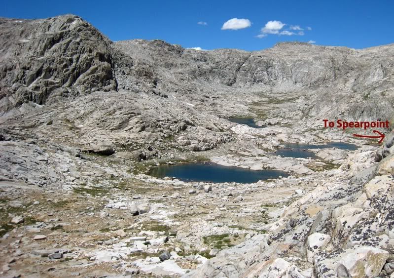
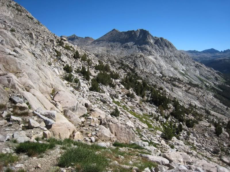
Some photos
View down West Pinnacle Creek from pass near upper Turrett Lakes
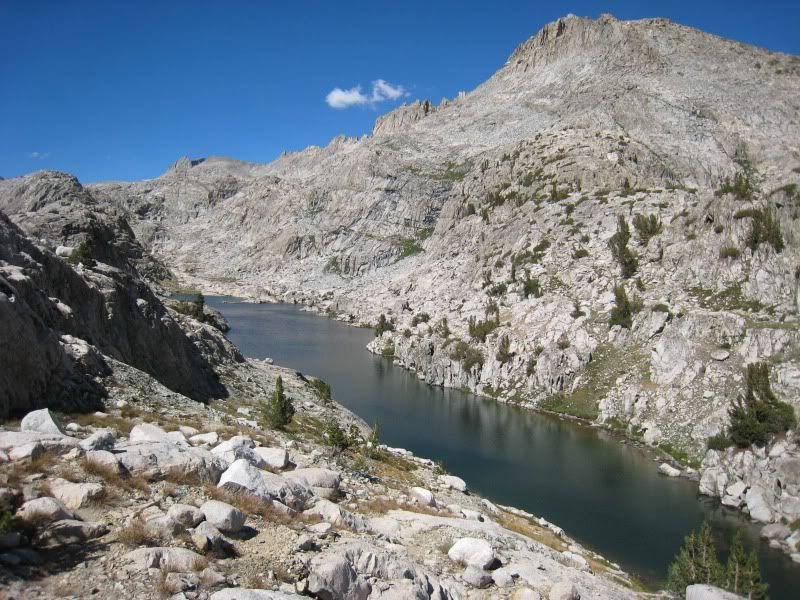
Spearpoint Lake
Traverse to East Pinnacle Creek
View down West Pinnacle Creek from pass near upper Turrett Lakes
Spearpoint Lake
Traverse to East Pinnacle Creek
-
RoguePhotonic
- Topix Fanatic
- Posts: 1693
- Joined: Thu Mar 24, 2011 9:52 am
- Experience: Level 4 Explorer
- Location: Bakersfield CA
- Contact:
Re: Hike Planning
Well good at least I know I shouldn't have any problems getting around there.
My plan originally for getting to Three Island Lake was to traverse all the way up West Pinnacles Creek to the Western flanks of Gemini but maybe it would be better to just head past Upper Turret Lakes and cross the past NE from Mt. Senger.
My plan originally for getting to Three Island Lake was to traverse all the way up West Pinnacles Creek to the Western flanks of Gemini but maybe it would be better to just head past Upper Turret Lakes and cross the past NE from Mt. Senger.
-
sekihiker

- Founding Member
- Posts: 959
- Joined: Sun Dec 18, 2005 2:47 pm
- Experience: Level 4 Explorer
- Location: Fresno
- Contact:
Re: Hike Planning
Travel through Red Mountain Basin, Bench Valley, and Blackcap Basin is not difficult or all that complex. It's so easy, even my dog wrote one of the trip reports at the following links. She didn't take any of the photos, however.RoguePhotonic wrote:
From where it leaves off I will try to figure out what is the best way to go through the Red Mountain and Black Cap Basins. It's a complex area and i'm not sure what is best to do there with the time frame. Due to the resupply issues that we talked about before I may make some route South through it all and then into Tehipite Valley and then up the Middle Fork on some route to South Lake.
http://sierrahiker.home.comcast.net/~si ... index.html" onclick="window.open(this.href);return false;
http://sierrahiker.home.comcast.net/~si ... index.html" onclick="window.open(this.href);return false;
http://sierrahiker.home.comcast.net/~si ... index.html" onclick="window.open(this.href);return false;
http://sierrahiker.home.comcast.net/~si ... index.html" onclick="window.open(this.href);return false;
http://sierrahiker.home.comcast.net/~si ... index.html" onclick="window.open(this.href);return false;
http://sierrahiker.home.comcast.net/~si ... index.html" onclick="window.open(this.href);return false;
http://sierrahiker.home.comcast.net/~si ... index.html" onclick="window.open(this.href);return false;
http://sierrahiker.home.comcast.net/~si ... index.html" onclick="window.open(this.href);return false;
http://sierrahiker.home.comcast.net/~si ... index.html" onclick="window.open(this.href);return false;
http://sierrahiker.home.comcast.net/WLe ... index.html" onclick="window.open(this.href);return false;
Who is online
Users browsing this forum: John Harper, Richardtr6 and 160 guests