Page 1 of 2
Water sources in Alta Peak Area?
Posted: Sun Sep 16, 2012 3:42 pm
by MountainMinstrel
I am ashamed to say that this is my first post in two years. I developed an intestinal issue that made the back country...well to put in bluntly, a sh***y experience (it turns out that at 54 years old I suddenly became lactose intolerant). I used the down time to get my '69 VW camper restored so that I have a great trail head vehicle. I though this summer would be the one when I could get back into the back country but a very stubborn Kidney stone kept me home all summer. I finally got a chance to get out this weekend (Day hiked Mitchel Peak). I might as well have been in heaven

So now on to my question. I have the last weekend of the month free and would like to do Alta Peak-Pear Lake as a two/three day loop. Will I find any water sources at Mehrten or Alta Meadow, or should I just plan on lugging in enough water to dry camp on day one? I have not had much fall experience due to college classes (that I finished last May

). I will carry the water if need be, but would rather not. What do you think?
Re: Water sources in Alta Peak Area?
Posted: Mon Sep 17, 2012 6:26 am
by SweetSierra
Welcome back to the Sierra and to hiking!
A short distance from the signed intersection to Alta Meadow as you're heading to Alta Peak on the Alta Peak trail is an ice-cold spring. It is right on the trail on the right-hand side as you're going up. It's perhaps a quarter mile from the Alta Meadow junction, but I don't remember exactly. Just keep an eye out for it after the short climb from Panther Gap.
Re: Water sources in Alta Peak Area?
Posted: Mon Sep 17, 2012 7:06 am
by AlmostThere
How are you getting from Alta to Pear?
There are tarns and lakes in the Tablelands as well as the spring at Alta Meadow.
Re: Water sources in Alta Peak Area?
Posted: Mon Sep 17, 2012 8:54 am
by atreehugger
As of mid-August,there was water at Mehrten Mdw and Alta Mdw.
There was water on the trail, 1/2 way from Panther Gap to Mehrten at the spring shown on the 7.5 topo.
There was also water on the trail, from the spring 1/4 mile east of Mehrten Mdw.
Have a great trip.
Re: Water sources in Alta Peak Area?
Posted: Mon Sep 17, 2012 3:08 pm
by MountainMinstrel
Thanks everyone. I am glad to hear that water will not be an issue even in this drought year.
AlmostThere, I will be taking a high route along the east side of the lake close to this route that SSSDave

or Shawn (the green line)
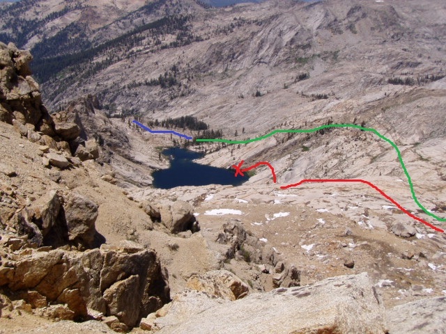
posted.
This will be the third time I have intended to complete the loop. he first time was from pear up and weather stopped us and the second time was from Alta Peak. That time I thought I could see the route but was unsure until I got home and looked at the pictures from here. I have confidence that I will complete the loop this time. Even if weather keeps me off of the peak, I will still go the long way around through the table lands.
Re: Water sources in Alta Peak Area?
Posted: Tue Sep 18, 2012 7:50 pm
by lambertiana
I did this loop just over two weeks ago. We went up via Pear Lake, and took a route not much different from the pink line shown in the map from SSSDave, and taking the right (east) fork to the top of the ridge. We stayed a little higher and looped along the eastern side of the basin. Lots of rock hopping there, but I like that. From the ridge itself, it looked like the western (left) fork on that map would be at least as easy as the one we took.
There were several small streams with very light flow still going on the south face of Alta, including the creek that drops down on the west side of Alta Meadow. We did not go to Alta Meadow, but the creek had enough flow to fill water bottles on the trail to the summit.
Re: Water sources in Alta Peak Area?
Posted: Wed Sep 19, 2012 4:09 pm
by MountainMinstrel
SweetSierra wrote:Welcome back to the Sierra and to hiking!
A short distance from the signed intersection to Alta Meadow as you're heading to Alta Peak on the Alta Peak trail is an ice-cold spring. It is right on the trail on the right-hand side as you're going up. It's perhaps a quarter mile from the Alta Meadow junction, but I don't remember exactly. Just keep an eye out for it after the short climb from Panther Gap.
I found my 7.5 TOPO so I can see the spring you mentioned. Is there any decent campsites near it? If possible I would like to make the TH at Woverton from there one day two. That way I can catch a day hike to Big Baldy on day three and still get home (Clovis) by 4:00. Then again a night at Pear or Emerald would be sweet too.
Re: Water sources in Alta Peak Area?
Posted: Wed Sep 19, 2012 7:33 pm
by SweetSierra
There are no campsites right at this spring. The closest campsites would be at Mehrten Meadow (see atreehugger's post above).
Re: Water sources in Alta Peak Area?
Posted: Wed Sep 19, 2012 8:31 pm
by MountainMinstrel
Thanks SweetSierra. That is what I remembered from the last trip. Mehrten was a nice spot and good for a late start (it might be 3:00 before I hit the trail on Friday). Looks like I will probably just make it a two night trip as I have not been out much at all and do not want to push too hard. Besides, sunrise at Pear lake is a special thing.
Re: Water sources in Alta Peak Area?
Posted: Tue Aug 25, 2020 9:38 am
by davidsheridan
I am re-purposing this old 2012 post for essentially the same question.
Is there water availability in Alta Meadow? I plan to stay there 2 nights this weekend.
I will be coming in from Wolverton on the standard trail route.
I heard there was a spring as you enter Alta Meadow.
Does anyone know if the spring is running in this dry year?
Also any more beta on the water sources at Mehrten or just above the Alta Meadow trail junction would be appreciated.
Many thanks for the beta