Page 3 of 5
Re: Kerrick / Matterhorn Canyon Loop (Cross Country Routes)
Posted: Fri Sep 28, 2012 1:34 pm
by phenocryst
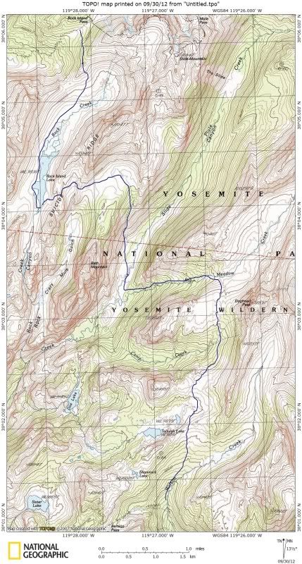
I have gone from Rock Island Lake to Slide canyon (10 yrs ago?) and from Slide to Rock Isl (last month). The route is straightforward in both directions but for me it was easier to find the best way going down (east). There was a little more decision-making involved going uphill... going down, the terrain just leads you.
I wondered if I would have trouble finding the ramp from the bottom but it is very obvious.
We approached via Wilson Creek and Tallulah and Doe. Again, routefinding is straightforward and hiking generally very easy. From the outlet of Doe Lake we headed northeast down an easy slope to Camp creek and down into Slide at the lower end of the meadows near the outlet of Big Meadow creek. The slope directly north of the outlet looked a lot less friendly.
I would strongly second the recommend to go via Rock Isl Lk rather than up Slide cyn... but The Slide is quite a sight and, if you have the time, worth a side trip to see.
Re: Kerrick / Matterhorn Canyon Loop (Cross Country Routes)
Posted: Fri Sep 28, 2012 10:55 pm
by mshields
phenocryst wrote:I have gone from Rock Island Lake to Slide canyon ........The route is straightforward in both directions but for me it was easier to find the best way going down (east).
We approached via Wilson Creek.....
From the outlet of Doe Lake we headed northeast down an easy slope to Camp creek and down into Slide at the lower end of the meadows near the outlet of Big Meadow creek.
Thanks for the input phenocryst.
- I am thinking of coming down from RIL and camping at the open area near Big Meadow Creek; at this location I can do a day hike to the slide. (best of both worlds)
- How far up did you proceed on Wilson Creek before heading west?
- I am assuming you stayed on the west side of Camp Creek on your way down from Doe?
Re: Kerrick / Matterhorn Canyon Loop (Cross Country Routes)
Posted: Fri Sep 28, 2012 11:00 pm
by mshields
oldranger wrote:
ask no more questions for a week as I enter the Eaglecap Wilderness tomorrow AM!

Mike
Oldranger,
I noticed you are back; I will have to come up with some questions

P.S. - Got "Splendid Mountains" in the mail today; am going to read the McClure section tonight.
mshields
Re: Kerrick / Matterhorn Canyon Loop (Cross Country Routes)
Posted: Sun Sep 30, 2012 8:29 pm
by Wandering Daisy
This is part of the trip I did in 2008, early season. Not saying it is the best route, but it worked. Just a warning- Slide Canyon meadow near Bath Mountain is FULL of mosquitoes. It was so bad that I could not even camp down there. However, Rock Island Lake was really pretty - still partly frozen and snow surrounding it. Dropping down the salbs to the meadow below Bath Mountain was quite steep. I had no previous information so I just winged it. I intersected the PCT near Benson Pass, then went back on the tril via Matterhorn Canyon, Burro Pass, Mule Pass, Robinson Lk.
Re: Kerrick / Matterhorn Canyon Loop (Cross Country Routes)
Posted: Mon Oct 01, 2012 12:13 am
by mshields
Wandering Daisy wrote: Just a warning- Slide Canyon meadow near Bath Mountain is FULL of mosquitoes. It was so bad that I could not even camp down there.
Thanks for that bit of info; I have heard a few others also mention this general area as being problematic. Perhaps a late season trip would help increase my odds?
I appreciate the topo. I noticed you went down Wilson Creek; do you recall how the navigation was through there?
Here is an interesting piece of history; that steep section you mentioned dropping down to the Slide Canyon meadows (below Bath Mountain) was navigated in 1895 by McClure on horseback. A couple HST members (TehipiteTom and OldRanger) gave me this piece of info. I just recently read McClures account in the "Splendid Mountains" book. Pretty cool stuff!
Thanks again
Re: Kerrick / Matterhorn Canyon Loop (Cross Country Routes)
Posted: Mon Oct 01, 2012 8:34 am
by oldranger
I know I've mentioned this before but my strategy for N. Yosemite is to limit my trips to Sept. of Wet years. Water available and no mosquitoes. We all know that mosquitoes early in the season doesn't necessarily translate to mosquitoes later in the season. Last year was an exception--plenty of water in september but also mosquitoes.
Mike
Re: Kerrick / Matterhorn Canyon Loop (Cross Country Routes)
Posted: Tue Oct 02, 2012 12:35 pm
by phenocryst
I concur with oldranger that late summer/Sept is the time to be in northern Yosemite. The last week of Aug there were no mosquitoes and water availability was pretty good even in a dry year. A couple of smaller streams shown on the topo were dry or nearly so, notably the creek draining Talullah lk, but Return, Matterhorn, Wilson and Piute creeks were all running well for late season. I will note that there had been quite a lot of recent rain.
Our route on Wilson creek was the same as Wandering Daisy's. There was no obvious trail but routefinding was easy, thru lodgepole woods near the creek, first 1/3 mi or so, and then n/e over open slabs leading to a wide pass east of Tallulah lk. Then west over wide open sand and meadow, easy going downstream to the meadow above Doe, and a nice trail down the n/e side of the creek. At the outlet we stayed to the right, then descended toward Camp ck, crossing probably pretty close to the bottom of the slope and contouring north. We came out east of the knob between the confluences of Camp and Big Mdw cks with Piute ck.
There isn't much to stress about here in terms of routefinding. The northern Yosemite high country is wonderfully easy and forgiving for the cross country traveler. Carry and use a topo, but let the mountains show you the way. McClure tells us "one going over this country must travel more or less by the great canyons, which correspond, in a rough way, to the streets of a mighty city". The great canyons are expressions of the overall jointing pattern in Yosemite granite that gives us wonderful seams, ramps and stairways to guide us from street to mighty street (and sometimes fissures and cliffs that stop us). There are meadows and open granite galore offering easy strolling and views of the surrounding terrain. If you can use a topo map you should have no trouble finding your way.
I too used McClure's account as both inspiration and instruction for my first visit here. Sometime I would like to try his entire route beyond Rock Island lk via Kerrick, Thompson and canyons north of the Sierra crest to "Jack Main's Canyon". His party took (but didn't necessarily ride) horses all the way (note that as they ascended the ramp out of Slide canyon, "We led our horses up this place, as is always my custom in a rough country").
Re: Kerrick / Matterhorn Canyon Loop (Cross Country Routes)
Posted: Tue Oct 02, 2012 8:48 pm
by mshields
phenocryst wrote: The northern Yosemite high country is wonderfully easy and forgiving for the cross country traveler. Carry and use a topo, but let the mountains show you the way. McClure tells us "one going over this country must travel more or less by the great canyons, which correspond, in a rough way, to the streets of a mighty city". The great canyons are expressions of the overall jointing pattern in Yosemite granite that gives us wonderful seams, ramps and stairways to guide us from street to mighty street (and sometimes fissures and cliffs that stop us). There are meadows and open granite galore offering easy strolling and views of the surrounding terrain. If you can use a topo map you should have no trouble finding your way.
Phenocryst,

Very well put ! (both yourself and McClure) Thanks again for your thoughts and input.
Re: Kerrick / Matterhorn Canyon Loop (Cross Country Routes)
Posted: Fri Feb 22, 2013 4:35 pm
by John Dittli
Sorry I came into this conversation a bit late, but I can answer some questions that have been raised here. First would be "Tower Pass" between Mary and Tower lakes. It is absolutely no problem. Stay along the trees in Old Rangers photo. I took my wife thru there no problem and she hates talus! I have skied through the pass just north of Tower Peak (east of the Pass) with no difficulties.
Crazy Mule Gulch is fantastic, and I found a way thru the cliffs into Slide last summer. A weakness about .5 miles east of the Crazy Mule Creek, a tiny bit of un-exposed class three. But there is only one way thru, so you have to hit it right! One may be able to follow the creek all the way down, but I haven't tested it.
Regarding the Bath Mountain ramp, you shouldn't have too much problem finding it from the top, but it is way more intimidating looking down it then up! (easy but visually exposed slabs)
I've been to Tullulah via Doe and upper Camp Creek, personally I prefer the latter as I find it more scenic and less convoluted.
Lastly, I was thru the entire Wilson Canyon from Doghead last summer, absolutely stunning in the upper reaches. No problem dropping into the PCT though it is forested. Found some old Calvery blazes in there but no trail. From Tallulah I've also gone via Shamrock Lakes; pretty straight forward.
Hope this helps. I could probably post photos if you are interested.
Re: Kerrick / Matterhorn Canyon Loop (Cross Country Routes)
Posted: Fri Feb 22, 2013 5:43 pm
by KathyW
mshields wrote:The Sierra's Are Game Over For Me This Year

Therefore I am occupying myself with the next best thing; planning next year's trip
Currently I have my sites set on the Kerrick/Matterhorn Canyon Loop in Northern Yosemite, but am interested in mixing it up a bit with some cross country travel. I have read several posts by HST members and come up with a couple good suggestions (thanks for the posts) If anyone has additional ideas or suggestions I would love to hear them!
- Level 3 Backpacking Experience
- Class 2 Terrain
- Main Interests: Photography/Great Campsites/Fishing
Thanks
I did that loop ten years ago and just loved it - it was just beautiful. I especially liked Slide Canyon - the views from Burro and Mule Passes were wonderful. Peeler, Benson, and Smedberg Lakes were really pretty, and Benson Lake is low enough elevation that you can swim in it in the summer without going numb. After that trip I decided I want to to go up to Horse Creek Pass and then on up to the summit of Matterhorn, which I finally did a couple years ago. I must say that I enjoyed the Kerrick/Matterhorn Loop backpacking trip better than the Matterhorn Peak death march day hike. Anyway, going over Horse Creek Pass wasn't very difficult if you decide to do that - I went over late in the season; so I was able to cross near the pass where there was a use trail and no snow.
Eventually, I'm going to go back to that area again.