Page 1 of 1
Circumnavigation of Goddard 8/14 - 8/27
Posted: Thu Aug 30, 2012 4:52 pm
by Mike M.
Just back from a two week trip in the Goddard area, starting on August 14th. Lots of rain and overcast weather the entire trip, with the exception of the last two days, which were bright, sunny and windy. Zero skeeters. It rained for seven hours our first day out (but did not rain that night). We started and ended at South Lake, circling Goddard via Bishop Pass --> Black Giant Pass --> Ionian Basin --> Reinstein Pass --> Davis Lake Pass --> Muir Pass and then back out via Bishop Pass. Except in the Dusy Basin Area, stream flows were surprisingly hearty -- we assume due to all the recent rain. Trails and terrain were well saturated with water and trail dust was minimal. Despite the uncharacteristically crummy weather, it was a fine time and the weather held up just enough to allow comfortable hiking for much of the day, most days. I pitched my tent three times during the adventure, but got rained on hard on a fourth night -- not a pretty picture. Saw few hikers once off the JMT highway -- no more than 4 in 8 days, including (we think) Moonwalker's group as they crossed a snowfield up near Scylla. We had a great time --more details and photos to follow in coming days in replies under this post.
Mike
Re: Circumnavigation of Goddard 8/14 - 8/27
Posted: Thu Aug 30, 2012 5:05 pm
by lostcoyote
looking forward to your pictures mike.
i may be headed back into ionian in a few weeks. depends on whether or not my buddy is going. since i have been there many times over, if he does not go, i will opt to head north from piute pass instead of heading south. we shall see.
i have a question.
how was the short steep section descending from lake 11828's outlet (the lake just south of black giant pass) as you are headed towards chasm lake?
that's one part of the basin that i have never done. have always gone over solomons pass & then on to lake 10232's paradise.
Re: Circumnavigation of Goddard 8/14 - 8/27
Posted: Thu Aug 30, 2012 5:46 pm
by Mike M.
Lostcoyote, it's not difficult. Stay to the north side of the creek and you'll find decent footing. Brother Van tried a more direct route, descending along the south side of the creek, but then crossed to the north side when he encountered steep rock.
Mike
Re: Circumnavigation of Goddard 8/14 - 8/27
Posted: Fri Aug 31, 2012 9:55 am
by Moonwalker
Sounds like a great trip Mike. Is Reinstein Pass what it looks like on my map, the pass between Mt Reinstein and Peak 12432? How did you do that and what was it like? We took Goddard Pass... I agree one nice thing about the cloudy weather was less trail dust than usual. Warmer nights, too. And though clouds were present almost every morning for 7 days, we only got rain once (8/14 in Darwin Canyon). Thanks for the post, and glad you noticed us!
-Eric
IMG_2294.jpg
Re: Circumnavigation of Goddard 8/14 - 8/27
Posted: Sat Sep 01, 2012 8:28 pm
by giantbrookie
Ah, this post brings back some fond memories. My wife did a trip we called "Ring Around the Goddard" in 1994. We went in via Lamarck Col and exited Lamarck on a 7 day trip that included Ionian Basin, Goddard Creek 10212 and vicinity, Blue Canyon, Martha Lake, Davis Lake and McGee Lakes, as well as a couple of quick hikes up Scylla and Mt Reinstein. The upshot was that the circumnavigation had not been planned in advance, for our original plan was some sort of in and back; we decided on the loop while at Goddard Creek.
I really look forward to seeing the photos.
Re: Circumnavigation of Goddard 8/14 - 8/27
Posted: Tue Sep 04, 2012 2:32 pm
by Mike M.
Moonwalker wrote:
Is Reinstein Pass what it looks like on my map, the pass between Mt Reinstein and Peak 12432? How did you do that and what was it like?
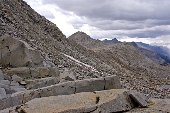
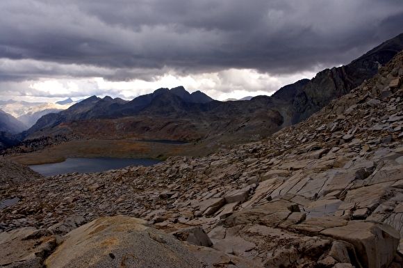
Yes, that is what I consider to be Reinstein Pass. It's a route I've used several times over the years -- just follow the obvious saddle shown on the topo map. It's relatively easy travel over slabs, benches, ledges, and blocks; take care to avoid the cliffs. This year I encountered a few duck marks high up on the route. I topped out during a lightning storm. Getting down to Martha Lake was easy, although I was nursing a sore knee. Once down, I chose to walk on the south side of the lake, heading west, making my way through a boulder field to the outlet. It would have been easier to simply walk around the entire lake -- I had to fight my way through some automobile sized obstacles. Just before the outlet, I happened across a terrific campsite, complete with a few scrawny trees, and chose to camp there.
Here's a photo from the top of the pass, looking over towards Valor and Confusion Passes:
Here's the gloomy view looking down to Martha Lake, with Mt. McGee in the distance:
Mike