GC Tuolumene - Ten Lks
Posted: Mon Jun 11, 2012 12:28 pm
Grand Canyon of the Tuolumne-Ten Lakes Loop
June 5-9, 2012
This is a loop trip I had planned over the winter. I only had to decide when to do it and which variation. I delayed a day due to reports of snow and left town at 6:30 AM on Tuesday. I picked up my permit at 9:00 and with White Wolf road closed and the new snow, the only reasonable option was to loop clockwise from Lukens Lake TH. Unfortunately, Tioga Road was still closed so I drove to the blockade and waited along with several others. Conditions could not have been better – cool in the canyon, clear skies, full moon, lots of good water sources, and low major river levels with no more than mid-calf wading required. Trip statistics: 54 miles, 12,000 feet elevation gain and loss, 4.5 days.

Day 1 (half day): 7.6 miles, +570 feet, -3025 feet, 5 hours. The road opened and I was on the trail by 11:00 AM with food for 6 days and several bail-out plans if the mosquitoes got horrible or if I got behind schedule. There was about an inch of fresh snow covering the ground and trees and a fierce cold north wind was blowing. I hiked in my jacket nearly the entire day, actually quite happy to have cool conditions instead of hot. First off, huge fresh bear tracks were all over the trail! So I started talking to the bears, who now have heard my repertoire of Dr. Seuss stories I read to the grandkids. “Red fish, blue fish; green eggs and ham”- hope the bears liked it. Lukens Lake was very pretty in the fresh snow. The trail became very soggy and snow was falling out of the trees. My feet were soon soaked. (Having accidently picked up my old same-brand hiking shoes that have been relegated to gardening. I am amazed they even lasted the trip!). Once I had descended to Morrison Creek snow was gone and there were lots of choices of campsites with plenty of water sources. I reached camp at 4:00 but had to check out camping on a nearby knob, finally returning to the standard campsite near the trail on a little saddle near the Morrison Creek trail crossing. I had a fine view of Hetch Hetchy. I saw nobody the entire day.

Lukens Lake

Hetch Hetchy from first campsite
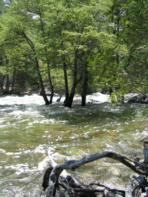
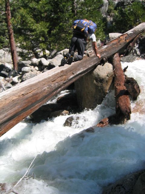
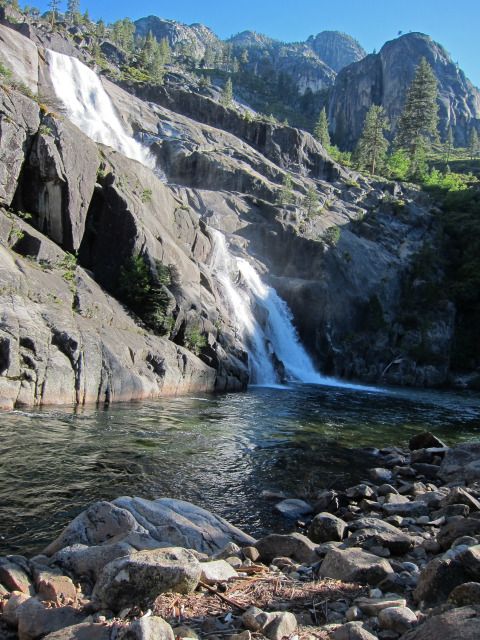
Day 2: 12.1 miles, +2350 feet, -2780 feet, 9.5 hours. Another day all by myself! My knees hurt so I was glad that I had not tried to descend to the river on the first day. I had forgotten how nice the camping was down at the river below Pate Valley. Pate Valley itself is miserable and having encountered several rattlesnakes here before I pounded my trekking poles loudly to warn them as I plowed through the deep grass. Last time I was here it was a swamp; this time it was dry. Thankfully it was still cool. Bear tracks and poop were present but thankfully no bears to be seen. Crossing Register Creek was a snap- mid-calf deep. Last time I was here in 2003 Memorial Day we had to shimmy a log upstream because the crossing was too swift and deep. I had planned on camping at the head of Muir Gorge, but there was none, so I continued. Across from the falls from Cathedral Creek there is a nice little knob/bench that is a few hundred feet off trail with good camping. I should have stopped. I thought that I could make it to the bridge at Return Creek so kept going. Within half a mile I got lost in a burned area where the trail was lost in debris. It was late and I was too tired to find the trail, so I turned around and went back to the campsite by Cathedral Creek. This was a fortunate decision because I found a really nice campsite with access to the river exactly where the falls entered. It was spectacular! I took a very cold bath and washed my shirt and enjoyed the lingering daylight. By now it was quite hot. I was excited about full moon on the canyon walls, only to discover that the moon was so low on the horizon and the canyon so deep that moonlight never reached the canyon walls! At least I did not have the bright moonlight keeping me awake. There were a few mosquitoes and some face-swarming gnats, but the wind kept them down so it was not bad at all.

Muir Gorge
Register Creek crossing

Cathedral Creek falls next to second day camp
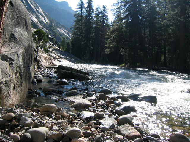
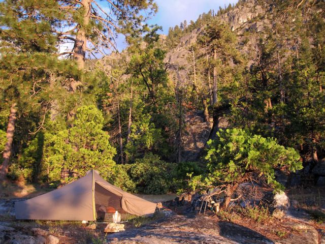
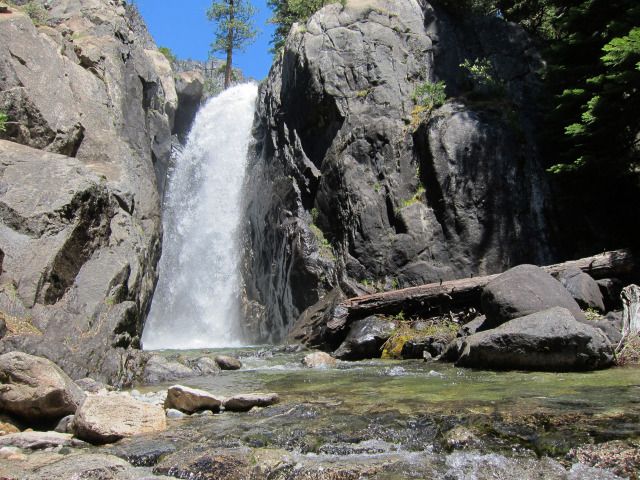
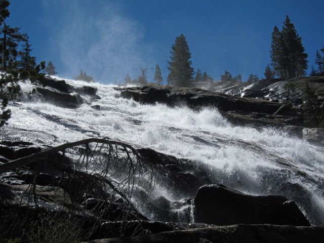
Day 3: 9.4 miles, +3350 feet, -710 feet, 8.5 hours. This day was the most spectacular. I stopped at every point I could get some photos of all the falls. One advantage of going upstream is that you want to stop and rest a lot. There are lots of little side trails that go closer to the falls. I ran into one other fellow as we bumped into each other from one falls to the next. At the top of Waterwheel Falls 4 hikers wanted me to take their photo. Near Glen Aulin I ran into several others. The infamous “swamp” required wading but nothing like my 2003 trip where we were crotch deep in water. My plan was to camp at McGee Lake, but I really did not like it, so continued. I waded across Cathedral Creek and did not like the camping there either. It was getting late and I was getting tired. I worried about water sources (no need to since all the minor trickles were running). I went about a mile and found a great campsite with a 360-degree view, on the very top of a rock knob just above a little stream. I went back down the stream, sat right in the middle of the trail crossing and took a bath and washed clothes- good thing nobody came along! Back up on my perch I had a very enjoyable evening. That night I had horrible arm twitches (like restless leg) and realized that I had this problem previously- and blamed it on Good Earth tea. I did not get to sleep until well past midnight. Basically there were no mosquitoes once I got past the Glen Aulin swamp.
Base of Waterwheel Falls

Top Waterwheel Falls

LeConte Falls "water wheel"

top pond of California Falls

Glen Aulin

Mt Conness from thrid day camp
Day 4: 12 miles- trail signs indicated 14, +3230 feet, -2065 feet and 9.5 hours. The trail to Ten Lakes is like a roller coaster and you seem to go back and forth like crazy. It and is only a few miles as the crow flies. The hike to the pass on the shoulder of Tuolumne Peak is in forest, a bit boring, but from the pass it is quite pretty with plenty of good views. There still is a bit of snow on the north side but the trail has been designed very well so it just skirted the snow banks. There was plenty of water so one could actually camp up here early season. The South Fork of Cathedral Creek is nicer than I had thought and there also was plenty of good camping. I had planned on camping at the meadow where the trail starts up to Ten Lakes, but reached this side by 2PM so decided to continue to Ten Lakes. I reached the upper lake by 4PM but this lake is surrounded by trees and the view is not the best, although the camp sites are luxurious. I decided to continue off-trail to the highest lake where the view was better but the camping was marginal. I found one established campsite and set up. The wind was cold and howling so no bath today! I explored the outlet area where I had hoped to find a more protected campsite but found none. During the evening the wind became stronger. I was a bit worried but had anchored my tent with huge rocks. I was more worried about trees falling down. The wind subsided by about 10PM and I put in earplugs to sleep and thankfully, slept well through the chilly night. I ran into one young fellow during this day- he asked me where he was, admitting that reading a map was not his aptitude! He was about 2 miles off and one ridge over from where he thought he was. As I age, I am amazed at the optimism of the young. Not knowing how to read a map did not seem to stop him. Oh, to again be young, strong and oblivious.

Tarn on top of Tuolumne Pass

Ten Lakes 9398

Ten Lakes upper lake - 4th night camp
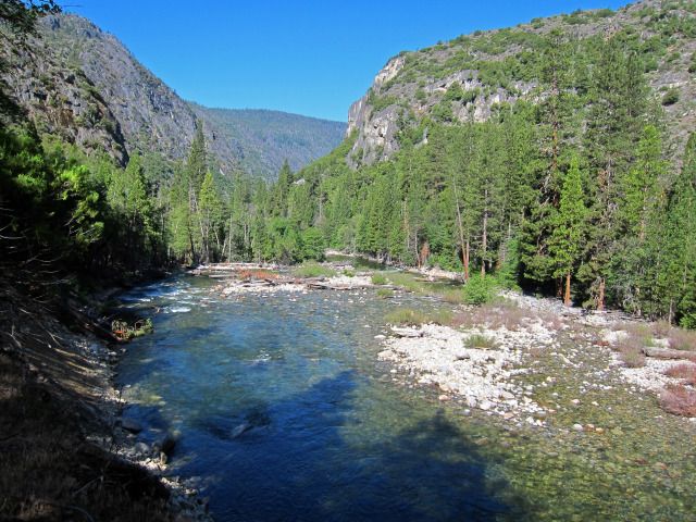
Day 5: 12.4 miles, +2300 feet, -2585 feet and 8.7 miles. I was off at 7:30 AM and spent the morning hiking through the Ten Lakes and then down to Grant Lake. The most scenic camping is at Lake 9021 outlet area. There were patches of ice on water as I descended cross country to this fine lake. At the larger main lake I met a father and sons who were fishing. I decided to go to Grant Lakes instead of the unnamed lake west of Grand Mountain. Grant Lake was a bit disappointing. Instead of taking the trail back up to Ten Lakes Pass I dropped down cross country (amazingly easy although very steep) to Halfmoon Meadow which was surprisingly dry. Then it was a matter of the long trudge out through thick forests. There were numerous fallen logs to climb over and I ran into several people on their way into Ten Lakes. I had planned on camping on the upper reaches of the Middle Tuolumne River, but after discovering that I forgot to pack a breakfast for the next day, I decided to just walk out. By 3PM I was nearly to the Lukens Lake junction and hot and tired. I found a nice spot away from the trail on the river and took a bath in a deep pool. I washed my shirt and put it on wet and it cooled me and was dry within a half hour! Lukens Lake sure looked different with the snow gone and full of tourists. I reached my car at 4PM and decided to drive home. For some reason I was not tired at all.

Most scenic of the Ten Lakes

No Snow at Lukens Lake on return
I have said on this forum that I thought going up-river offered better views. I recant that statement! The views are better going down the Grand Canyon of the Tuolumne. But to really enjoy it you need to slow down because it is too easy to just glide on downhill. At least going up, you are more inclined to take lots of breaks. I was a bit under impressed with Ten Lakes. They are pretty but I prefer the higher alpine lakes. I was lucky in that there were few people at Ten Lakes, which can get very crowded in the summer.
June 5-9, 2012
This is a loop trip I had planned over the winter. I only had to decide when to do it and which variation. I delayed a day due to reports of snow and left town at 6:30 AM on Tuesday. I picked up my permit at 9:00 and with White Wolf road closed and the new snow, the only reasonable option was to loop clockwise from Lukens Lake TH. Unfortunately, Tioga Road was still closed so I drove to the blockade and waited along with several others. Conditions could not have been better – cool in the canyon, clear skies, full moon, lots of good water sources, and low major river levels with no more than mid-calf wading required. Trip statistics: 54 miles, 12,000 feet elevation gain and loss, 4.5 days.
Day 1 (half day): 7.6 miles, +570 feet, -3025 feet, 5 hours. The road opened and I was on the trail by 11:00 AM with food for 6 days and several bail-out plans if the mosquitoes got horrible or if I got behind schedule. There was about an inch of fresh snow covering the ground and trees and a fierce cold north wind was blowing. I hiked in my jacket nearly the entire day, actually quite happy to have cool conditions instead of hot. First off, huge fresh bear tracks were all over the trail! So I started talking to the bears, who now have heard my repertoire of Dr. Seuss stories I read to the grandkids. “Red fish, blue fish; green eggs and ham”- hope the bears liked it. Lukens Lake was very pretty in the fresh snow. The trail became very soggy and snow was falling out of the trees. My feet were soon soaked. (Having accidently picked up my old same-brand hiking shoes that have been relegated to gardening. I am amazed they even lasted the trip!). Once I had descended to Morrison Creek snow was gone and there were lots of choices of campsites with plenty of water sources. I reached camp at 4:00 but had to check out camping on a nearby knob, finally returning to the standard campsite near the trail on a little saddle near the Morrison Creek trail crossing. I had a fine view of Hetch Hetchy. I saw nobody the entire day.
Lukens Lake
Hetch Hetchy from first campsite
Day 2: 12.1 miles, +2350 feet, -2780 feet, 9.5 hours. Another day all by myself! My knees hurt so I was glad that I had not tried to descend to the river on the first day. I had forgotten how nice the camping was down at the river below Pate Valley. Pate Valley itself is miserable and having encountered several rattlesnakes here before I pounded my trekking poles loudly to warn them as I plowed through the deep grass. Last time I was here it was a swamp; this time it was dry. Thankfully it was still cool. Bear tracks and poop were present but thankfully no bears to be seen. Crossing Register Creek was a snap- mid-calf deep. Last time I was here in 2003 Memorial Day we had to shimmy a log upstream because the crossing was too swift and deep. I had planned on camping at the head of Muir Gorge, but there was none, so I continued. Across from the falls from Cathedral Creek there is a nice little knob/bench that is a few hundred feet off trail with good camping. I should have stopped. I thought that I could make it to the bridge at Return Creek so kept going. Within half a mile I got lost in a burned area where the trail was lost in debris. It was late and I was too tired to find the trail, so I turned around and went back to the campsite by Cathedral Creek. This was a fortunate decision because I found a really nice campsite with access to the river exactly where the falls entered. It was spectacular! I took a very cold bath and washed my shirt and enjoyed the lingering daylight. By now it was quite hot. I was excited about full moon on the canyon walls, only to discover that the moon was so low on the horizon and the canyon so deep that moonlight never reached the canyon walls! At least I did not have the bright moonlight keeping me awake. There were a few mosquitoes and some face-swarming gnats, but the wind kept them down so it was not bad at all.
Muir Gorge
Register Creek crossing
Cathedral Creek falls next to second day camp
Day 3: 9.4 miles, +3350 feet, -710 feet, 8.5 hours. This day was the most spectacular. I stopped at every point I could get some photos of all the falls. One advantage of going upstream is that you want to stop and rest a lot. There are lots of little side trails that go closer to the falls. I ran into one other fellow as we bumped into each other from one falls to the next. At the top of Waterwheel Falls 4 hikers wanted me to take their photo. Near Glen Aulin I ran into several others. The infamous “swamp” required wading but nothing like my 2003 trip where we were crotch deep in water. My plan was to camp at McGee Lake, but I really did not like it, so continued. I waded across Cathedral Creek and did not like the camping there either. It was getting late and I was getting tired. I worried about water sources (no need to since all the minor trickles were running). I went about a mile and found a great campsite with a 360-degree view, on the very top of a rock knob just above a little stream. I went back down the stream, sat right in the middle of the trail crossing and took a bath and washed clothes- good thing nobody came along! Back up on my perch I had a very enjoyable evening. That night I had horrible arm twitches (like restless leg) and realized that I had this problem previously- and blamed it on Good Earth tea. I did not get to sleep until well past midnight. Basically there were no mosquitoes once I got past the Glen Aulin swamp.
Base of Waterwheel Falls
Top Waterwheel Falls
LeConte Falls "water wheel"
top pond of California Falls
Glen Aulin
Mt Conness from thrid day camp
Day 4: 12 miles- trail signs indicated 14, +3230 feet, -2065 feet and 9.5 hours. The trail to Ten Lakes is like a roller coaster and you seem to go back and forth like crazy. It and is only a few miles as the crow flies. The hike to the pass on the shoulder of Tuolumne Peak is in forest, a bit boring, but from the pass it is quite pretty with plenty of good views. There still is a bit of snow on the north side but the trail has been designed very well so it just skirted the snow banks. There was plenty of water so one could actually camp up here early season. The South Fork of Cathedral Creek is nicer than I had thought and there also was plenty of good camping. I had planned on camping at the meadow where the trail starts up to Ten Lakes, but reached this side by 2PM so decided to continue to Ten Lakes. I reached the upper lake by 4PM but this lake is surrounded by trees and the view is not the best, although the camp sites are luxurious. I decided to continue off-trail to the highest lake where the view was better but the camping was marginal. I found one established campsite and set up. The wind was cold and howling so no bath today! I explored the outlet area where I had hoped to find a more protected campsite but found none. During the evening the wind became stronger. I was a bit worried but had anchored my tent with huge rocks. I was more worried about trees falling down. The wind subsided by about 10PM and I put in earplugs to sleep and thankfully, slept well through the chilly night. I ran into one young fellow during this day- he asked me where he was, admitting that reading a map was not his aptitude! He was about 2 miles off and one ridge over from where he thought he was. As I age, I am amazed at the optimism of the young. Not knowing how to read a map did not seem to stop him. Oh, to again be young, strong and oblivious.
Tarn on top of Tuolumne Pass
Ten Lakes 9398
Ten Lakes upper lake - 4th night camp
Day 5: 12.4 miles, +2300 feet, -2585 feet and 8.7 miles. I was off at 7:30 AM and spent the morning hiking through the Ten Lakes and then down to Grant Lake. The most scenic camping is at Lake 9021 outlet area. There were patches of ice on water as I descended cross country to this fine lake. At the larger main lake I met a father and sons who were fishing. I decided to go to Grant Lakes instead of the unnamed lake west of Grand Mountain. Grant Lake was a bit disappointing. Instead of taking the trail back up to Ten Lakes Pass I dropped down cross country (amazingly easy although very steep) to Halfmoon Meadow which was surprisingly dry. Then it was a matter of the long trudge out through thick forests. There were numerous fallen logs to climb over and I ran into several people on their way into Ten Lakes. I had planned on camping on the upper reaches of the Middle Tuolumne River, but after discovering that I forgot to pack a breakfast for the next day, I decided to just walk out. By 3PM I was nearly to the Lukens Lake junction and hot and tired. I found a nice spot away from the trail on the river and took a bath in a deep pool. I washed my shirt and put it on wet and it cooled me and was dry within a half hour! Lukens Lake sure looked different with the snow gone and full of tourists. I reached my car at 4PM and decided to drive home. For some reason I was not tired at all.
Most scenic of the Ten Lakes
No Snow at Lukens Lake on return
I have said on this forum that I thought going up-river offered better views. I recant that statement! The views are better going down the Grand Canyon of the Tuolumne. But to really enjoy it you need to slow down because it is too easy to just glide on downhill. At least going up, you are more inclined to take lots of breaks. I was a bit under impressed with Ten Lakes. They are pretty but I prefer the higher alpine lakes. I was lucky in that there were few people at Ten Lakes, which can get very crowded in the summer.