It's a little out of the way, but Hungry Packer Lake with views of Picture Puzzle Peak is a much more scenic place to camp.
Ascending the east side of Echo we had to circle high on the south slopes above the lake because of "dirty" ice, i.e., be wary of what may look like sandy slopes.
Trip Advice: Ionian - Evolution - Darwin Loop
-
fourputt

- Topix Acquainted
- Posts: 83
- Joined: Thu Aug 11, 2011 10:25 am
- Experience: N/A
-
Bluewater

- Topix Expert
- Posts: 584
- Joined: Sun Oct 23, 2011 3:33 pm
- Experience: Level 4 Explorer
- Location: Laguna Beach
- Contact:
Re: Trip Advice: Ionian - Evolution - Darwin Loop
Thanx rogue, it sounds like bringing and ice axe may be a good idea. Do you find that micro spikes are enough when going up steep snow fields?
@tim; The area with the lakes above Goddard Canyon between Davis and Martha Lakes look like a potentially amazing spot, although this is just based on maps and Google Earth. I've read one trip report on HST of a 'ring around Goddard' type trip that included this area. Secor describes a route from Davis to Martha Lakes by following the benches to the southwest of the lake outlet, "Martha Lake can be reached from Davis Lake by heading southwest from the outlet of Davis Lake and climbing onto a bench at approximately 11,200 feet. Turn south and climb onto another bench between 11,400 and 11,600 feet. Follow a series of lakes along this bench and descend southwest to Martha Lake". This sounds appealing, but the reality may be much harder than it looks on paper. I'm hoping for an adventure into a great spot. We'll see..
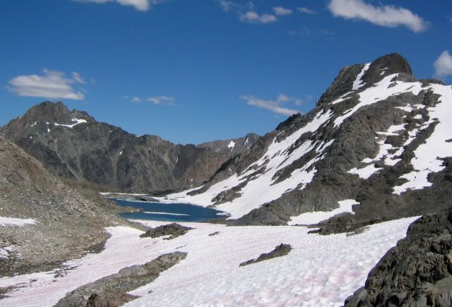
@fourputt; Thanx for the camping tip at Hungry Packer Lake. Awesome! When hiking above Echo Lake I will look out for what may look like sandy slopes above and to the south. From what I've read the route around Echo Lake toward the Col (when coming from Sabrina) involves following the cliffs above and to the east of the lake, then following the snowfield up toward the chimney with the dark colored rocks. Did you find that crampons and an ice ax were needed on the way over the col? Any other tips for making it over Echo Col would be appreciated.
Here's one of the better pictures I have found of the approach to Echo Col from the northeast:
@tim; The area with the lakes above Goddard Canyon between Davis and Martha Lakes look like a potentially amazing spot, although this is just based on maps and Google Earth. I've read one trip report on HST of a 'ring around Goddard' type trip that included this area. Secor describes a route from Davis to Martha Lakes by following the benches to the southwest of the lake outlet, "Martha Lake can be reached from Davis Lake by heading southwest from the outlet of Davis Lake and climbing onto a bench at approximately 11,200 feet. Turn south and climb onto another bench between 11,400 and 11,600 feet. Follow a series of lakes along this bench and descend southwest to Martha Lake". This sounds appealing, but the reality may be much harder than it looks on paper. I'm hoping for an adventure into a great spot. We'll see..
@fourputt; Thanx for the camping tip at Hungry Packer Lake. Awesome! When hiking above Echo Lake I will look out for what may look like sandy slopes above and to the south. From what I've read the route around Echo Lake toward the Col (when coming from Sabrina) involves following the cliffs above and to the east of the lake, then following the snowfield up toward the chimney with the dark colored rocks. Did you find that crampons and an ice ax were needed on the way over the col? Any other tips for making it over Echo Col would be appreciated.
Here's one of the better pictures I have found of the approach to Echo Col from the northeast:
You do not have the required permissions to view the files attached to this post.
-
fourputt
- Topix Acquainted
- Posts: 83
- Joined: Thu Aug 11, 2011 10:25 am
- Experience: N/A
Re: Trip Advice: Ionian - Evolution - Darwin Loop
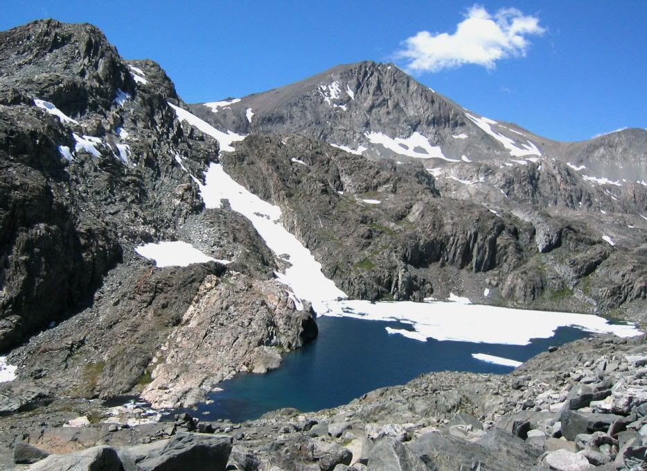
It's one of those 2 right dark notches ... memory's a funny thing so can't be sure. I do remember that I searched left in the lighter rock and found an unusable cliff.
Instructions to circle high sounds like it means avoiding the icy slopes of the glacier (or what's left of it).
... and looking again I'd guess the rightmost.
Instructions to circle high sounds like it means avoiding the icy slopes of the glacier (or what's left of it).
... and looking again I'd guess the rightmost.
-
tim
- Topix Expert
- Posts: 516
- Joined: Thu Feb 12, 2009 2:36 pm
- Experience: N/A
- Location: Bay Area
Re: Trip Advice: Ionian - Evolution - Darwin Loop
Here's a photo of the west end of Davis Lake. I think you go round behind the knoll in the left foreground or you will end up at a cliff just before the outlet (as the photo shows). The rest of your route after the outlet sounds right.
http://blog.outwild.net/Ionian%20Basin/index.cgi?j=7" onclick="window.open(this.href);return false;
http://blog.outwild.net/Ionian%20Basin/index.cgi?j=7" onclick="window.open(this.href);return false;
-
maverick

- Forums Moderator

- Posts: 11834
- Joined: Thu Apr 06, 2006 5:54 pm
- Experience: Level 4 Explorer
Re: Trip Advice: Ionian - Evolution - Darwin Loop
Here you go Andy: http://www.youtube.com/watch?v=yFnuM6vNfg0" onclick="window.open(this.href);return false;
Professional Sierra Landscape Photographer
I don't give out specific route information, my belief is that it takes away from the whole adventure spirit of a trip, if you need every inch planned out, you'll have to get that from someone else.
Have a safer backcountry experience by using the HST ReConn Form 2.0, named after Larry Conn, a HST member: http://reconn.org
-
RoguePhotonic

- Topix Fanatic
- Posts: 1693
- Joined: Thu Mar 24, 2011 9:52 am
- Experience: Level 4 Explorer
- Location: Bakersfield CA
- Contact:
Re: Trip Advice: Ionian - Evolution - Darwin Loop
I don't know since I have never tried but i'm pretty sure that they are not. I couldn't see them being effective on steep snow at all. The best you could hope for is if you were cutting foot holds they would offer a nice grip on those. I may regret taking them since it's an extra 15 ounces.Do you find that micro spikes are enough when going up steep snow fields?
-
Mike M.
- Topix Expert
- Posts: 647
- Joined: Fri May 25, 2007 10:50 pm
- Experience: Level 4 Explorer
- Location: Portland, Oregon
Re: Trip Advice: Ionian - Evolution - Darwin Loop
Bluewater, I'm jumping into this conversation late . . . here's my two cents:
I've hiked most of the route you have mapped out several times, with the exception of Echo Col. I've avoided Echo Col because of the possibility of ice at the top on the eastern (Echo Lake) side -- I'm not comfortable with routes that are exposed and/or require ice axes. That said, this is going to be a very low snow year and it is likely you will find the conditions good this year (i.e., mostly ice free). In that case, route finding is key.
Either way you do your route, starting at Echo Col or starting at Lamarck Col, your itinerary is challenging. Too ambitious for this old fart! I would add two extra days and avoid the death march.
Day 2 is a hard one, only your second day in altitude. Do-able, but strenuous -- you'll be on your feet for many hours. May I suggest: there is an excellent campsite about a mile before Helen Lake, next to a stream coming down from the crest near Wallace and Fiske. (Coming down from Echo Col, just where you meet up with the Muir Trail, is a lake. From here, the trail switchbacks up toward Helen Lake. The campsite is at a bench at the top of the first series of switchbacks. There is a little grove of trees here (on the left) and a nice vista looking down the head of Le Conte Canyon.)
Day 3 is a killer, because it includes the detour to climb Black Giant. You could easily see yourself on your feet for 8 hours this day.
Day 5 is ambitious, at least a five hour day, likely more.
Day 6 is another killer day, because it includes the long climb to and from Mt. Goddard, then a tiresome climb over Davis Col. Davis Col looks trivial on the map, but you'll be tired by then and the route will take some effort. Easy once you meet the trail. Another very long day.
Mike
-
Bluewater
- Topix Expert
- Posts: 584
- Joined: Sun Oct 23, 2011 3:33 pm
- Experience: Level 4 Explorer
- Location: Laguna Beach
- Contact:
Re: Trip Advice: Ionian - Evolution - Darwin Loop
@fourputt, thanks for the confirmation on the rightmost notch on the east side of Echo Col. Although I was hoping to climb up that part from the east side, it looks like I'll be heading down that on the way out. At least I'll be many days into the trip and carrying a light load.
@tim, that photo of Davis Lake from way up the southern slope gives a great perspective. From the looks of it I would have hit an impassable cliff. Here's a quick detail map of the better way, does this look right?
@maverick; the 'run the planet fr' person on youtube must be an ultra-runner. I was watching one of his other videos called Evolution and it looks like he's running the JMT down from the hut toward Wanda. Yikes. thanks for the link to his Echo video, I've been enjoying the detailed footage of him climbing over the east side of Echo Col.
Thanx for your comments Mike M. I may have camped nearby the site you described overlooking the head of Le Conte Canyon last summer while on the JMT. I remember the vista overlooking Le Conte, amazing views. I'm planning on adding 2 contingency days and reversing the order of the trip.
Does this seem more reasonable/realistic? I'm open to any advice. . .
Day 1: North Lake TH to tarn just below Lamarck Col (5 miles)
Day 2: Over Lamarck Col to Darwin Bench (3.5 miles)
Day 3: Darwin Bench to Davis Lake (6.6 miles)
Day 4: Climb Mt. Goddard (3.8 miles)
Day 5: Davis Lake to tarn above Martha Lake (5 miles)
Day 6: Tarn above Martha Lake to Scylla Lake (3 miles + possible side trip/climb Scylla)
Day 7: Scylla to lake 11,828 (4 miles + possible side trip/climb Scylla)
Day 8: Lake 11,828, Black Giant, to Lake 11,428 below Echo Col (4.5 miles)
Day 9: Echo Col to Sabrina (9 miles)
This is a basic outline, some flexibility is built-in (and low mileage in the beginning). Here's an overview map:
You do not have the required permissions to view the files attached to this post.
-
Wandering Daisy
- Topix Docent
- Posts: 6689
- Joined: Sun Jan 24, 2010 8:19 pm
- Experience: N/A
- Location: Fair Oaks CA (Sacramento area)
- Contact:
Re: Trip Advice: Ionian - Evolution - Darwin Loop
You will have plenty of time for a wonderful day-hike to the upper lakes on Darwin Bench.
You can also climb Mt. Goddard from Ionion Basin if for some reason weather scrubs your first choice. I climbed Mt. Goddard from the small ponds north of Martha Lake on the west side of Goddard. It goes, but is not a highly recommended route (lots of loose stuff down low).
If you are going light, get an early start, and are pre-aclimated you could get to down to the string of lakes below Lamark Col on Day 1. The advantage of this is that you go up over the snowfield on Lamark Col in the late afternoon when the snow is softer. If there is no snow, this of course is not an issue. There are even flat spots near a little creek about half way down from Lamark. When I did this route, my plan was to get over the Col, but I ended up altitude sick so had to stop at the tarn on the east side. At any rate, there are plenty of options to deal with afternoon storms or altitude sickness.
these photos were taken in Aug 15-16 2006 so you can get an idea of the conditions. There will be less snow this year, but given last years 200% snowpack and the tendency of Ionian Basin to hold snow I suspect that you may have to deal with some very hard old snow that remains from last year.

Camp below Scylla

View towards Lake 11818 from Reinstein Pass
Approaching Lake 11818
View back at Lake 11818 on way to lake below Scylla

Lake below Scylla bench

map of route
You can also climb Mt. Goddard from Ionion Basin if for some reason weather scrubs your first choice. I climbed Mt. Goddard from the small ponds north of Martha Lake on the west side of Goddard. It goes, but is not a highly recommended route (lots of loose stuff down low).
If you are going light, get an early start, and are pre-aclimated you could get to down to the string of lakes below Lamark Col on Day 1. The advantage of this is that you go up over the snowfield on Lamark Col in the late afternoon when the snow is softer. If there is no snow, this of course is not an issue. There are even flat spots near a little creek about half way down from Lamark. When I did this route, my plan was to get over the Col, but I ended up altitude sick so had to stop at the tarn on the east side. At any rate, there are plenty of options to deal with afternoon storms or altitude sickness.
these photos were taken in Aug 15-16 2006 so you can get an idea of the conditions. There will be less snow this year, but given last years 200% snowpack and the tendency of Ionian Basin to hold snow I suspect that you may have to deal with some very hard old snow that remains from last year.
Camp below Scylla
View towards Lake 11818 from Reinstein Pass
Approaching Lake 11818
View back at Lake 11818 on way to lake below Scylla
Lake below Scylla bench
map of route
-
Wandering Daisy
- Topix Docent
- Posts: 6689
- Joined: Sun Jan 24, 2010 8:19 pm
- Experience: N/A
- Location: Fair Oaks CA (Sacramento area)
- Contact:
Re: Trip Advice: Ionian - Evolution - Darwin Loop
Here is a scan of my route notes. Not saying my choice of route was the best. This is a 6MG file I can send you if you send me a PM.

Who is online
Users browsing this forum: No registered users and 52 guests