Page 3 of 5
Re: TR: South Lake to North Lake to South Lake complete loop
Posted: Tue Aug 09, 2011 8:25 am
by kpeter
dsotm wrote:No real problem with mosquitoes then? Coming from Arizona to do this loop in 2 weeks. Looks like it's going to be worth the trip!
Mosquitoes were horrible at the upper Tyee Lakes and pretty bad at Piute. They were all above 9500 feet when I was there, and so lower Piute canyon and Goddard Canyon were completely free of them. Evolution Valley and Evolution Lake might have been bad, but it rained and they did not come out. I encountered them again coming up to and traveling through Dusy Basin, but I passed through quickly enough that they were not a problem for me. Again, people reported them being bad in the Long Lake area.
In short, by the time you do this trip, they will probably be confined to the highest elevation band.
Re: TR: South Lake to North Lake to South Lake complete loop
Posted: Tue Aug 09, 2011 8:30 am
by kpeter
DoyleWDonehoo wrote:I have long wanted to go up to Ladder Lake (there use to be a trail to it), and I think one of your pictures had Ladder Cascade in it.
Thank you Doyle, I've long so admired your trip reports and they were really the inspiration for me to try to give a little something back.
I took a look at the maps and while I have a shot or two of cascades coming down the west side of Le Conte canyon, they are north of the Ladder Lake/Cascade area. If (from my vantage on the east wall of the canyon, coming up the Dusy switchbacks) I had pivoted and taken the shot to the SW instead of to the W or NW I could have gotten the Ladder Cascades, but I did not. It does indeed look like a very interesting spot.
Re: TR: South Lake to North Lake to South Lake complete loop
Posted: Tue Aug 09, 2011 8:34 am
by kpeter
frediver wrote:The weather conditions have really thrown a wrench into
plans this year, I hope winter snows do not start early. Whacha think???
It hailed on me, and I was told by other backpackers that the day before I got to the Evolution area there were as much as two inches of hail that accumulated. That was in July. So be prepared for anything, but September is usually a good month in the Sierras.
Re: TR: South Lake to North Lake to South Lake complete loop
Posted: Tue Aug 09, 2011 8:57 am
by Wandering Daisy
Well my reply got lost in the big black iternet hole! So here we go again. I have been up to Ladder Lake via two routes- from lower LeConte Canyon and leaving the PCT on the east side of Black Giant. The latter is my preference, although it is more "technical" requiring LOTS of talus hopping and a few steep snow sections, depending time of year. The lower route is more miserable, and you have to find a crosssing (not easy). There are game trails to be found, but we still had to do a considerable amount of bush whacking. It got easier as we ascended. Ladder Lake is wonderful- well worth the effort. If anyone is interested I might be able to dig up some maps with the routes.
Ladder Lake
Posted: Tue Aug 09, 2011 3:47 pm
by DoyleWDonehoo
Wandering Daisy wrote:I have been up to Ladder Lake via two routes-... Ladder Lake is wonderful- well worth the effort. If anyone is interested I might be able to dig up some maps with the routes.
I would like to see the maps and routes, but also most of all pictures if you have them. I have read about the area in Fiddler's Sierra Classics (and the class 2 route on The Citadel), which has few details. By all accounts Ladder Lake is very nice. Thanks in advance.
Re: TR: South Lake to North Lake to South Lake complete loop
Posted: Wed Aug 10, 2011 10:13 am
by Wandering Daisy
Sorry, I did not take a camera on this trip. Here is the map.
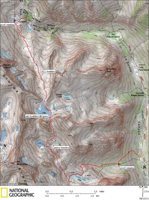
Re: TR: South Lake to North Lake to South Lake complete loop
Posted: Thu Aug 11, 2011 3:17 pm
by DoyleWDonehoo
Wandering Daisy wrote:Sorry, I did not take a camera on this trip. Here is the map.
Someday someone will post some pictures. *sigh* Thanks for the map. I have read about the northern route before, and the eastern route is just about what I figured as the logical way. Good camp suggestion on the east route: I would not have thought of that or known it was there. Nice.
Re: TR: South Lake to North Lake to South Lake complete loop
Posted: Fri Apr 20, 2012 10:14 pm
by Eiprahs

Ladder Lake has always interested me so I was most pleased to find this thread. Here's a photo of Ladder Lake's outlet stream cascading into LeConte Canyon.
Doyle, I thought I could see parts of a trail to the right of the cascade--doesn't show well in photo--but I studied the scene for a long time and wondered, if that was a trail, where it might have taken off from the JMT. Do you have a map showing the trails location?
Anyhow, not too far South from the LeConte Ranger Cabin, you can look up into the hanging valley and see the cascade just below Ladder Lake. That was into the sun, so I didn't take a photo.
Thank you, Wandering Daisy, for your map. I ran across a trip account about crossing Echo Col that has photos showing part of your route and boy did that look like a taylus slog. Your knees must be holding up better than mine.

Eiprahs
Re: TR: South Lake to North Lake to South Lake complete loop
Posted: Sat Apr 21, 2012 8:58 am
by kpeter
I have combed through my photos from the loop trip and found one that might show the Ladder Lake area. I've photoshopped it and added labels that reflect my guesses as to the approximate location of landscape features. I could be wrong though...people should feel free to chime in and correct me.
Skyline.jpg
Note that the photos from earlier in my trip report that Doyle thought might be the cascades coming out of Ladder Lake turned out to be similar cascades coming out of the Hester Lake area, which is immediately West of the trail up to lower Dusy Basin. To get a shot of Ladder Lake you have to look sharply SW, diagonally across the canyon.
By taking the southernmost part of my skyline shot and blowing it up, it turns out that I can just see the glint off the water of Ladder Lake. I've highlighted it in the englargement below in bright blue and labeled it in red.
Don't be confused by the shadowed slope in the bottom left of the enlargement--that is on the East side of LeConte Canyon and partly blocks the view of the outlet area of Ladder Lake. The photo makes more sense when you realize I am well to the NE of Ladder lake and shooting at a fairly sharp angle to the canyon.
Ladder Lake Colored2.jpg
Re: TR: South Lake to North Lake to South Lake complete loop
Posted: Sat Apr 21, 2012 11:00 am
by RoguePhotonic
Someday someone will post some pictures. *sigh* Thanks for the map.
As long as I survive my hike as planned this summer I will bring back detailed photos and descriptions.
