If you've been searching for the best source of information and stimulating discussion related to Spring/Summer/Fall backpacking, hiking and camping in the Sierra Nevada...look no further!
It's nice to see the live map in action, but I don't think TenderPaw needs map skills. I thought this thread was more about are certain passes "doable." TenderPaw, I would trust Mav and LC's guidance once you pick a proposed route and identify secondaries. We wouldn't want you to have to use that PLB either.
I was not trying to imply that at all. Instead, I posted for two reasons.
First, I think a big value of forums like these is to help people learn about areas. Certainly including a map in a thread can help with that. No doubt there are people reading this thread that don’t know much about this area and are not familiar with the peaks and other named features that have been mentioned. (I’m one of them.)
Second, OK - time to ‘fess up. The other reason I posted was to show a practical example of using the new Gmap4LL button that Eric added to the screen where we compose our posts.
BTW, to see the map full screen just click Menu ==> Full Screen
Before you go over Amp. Pass be sure to read from the Secor book which explains how to go over the pass when there is a cornice on it which there will probably be all summer this year.
I like what you are doing -- looking at topo maps and dreaming up possible routes for the summer. Don't worry if you don't know anyone who has done the route, or if the route isn't listed in Secor's guide. Back in the day, before Secor and the internet, all we had was Roper's Climber's Guide and our trusty 15 minute U.S. Geological Survey Maps. And every hike was a new adventure, with each of us his own pathfinder.
If you see a route that might go, try it. Give yourself plenty of time and be prepared to be flexible. Know your limits and reroute if you are uncomfortable.
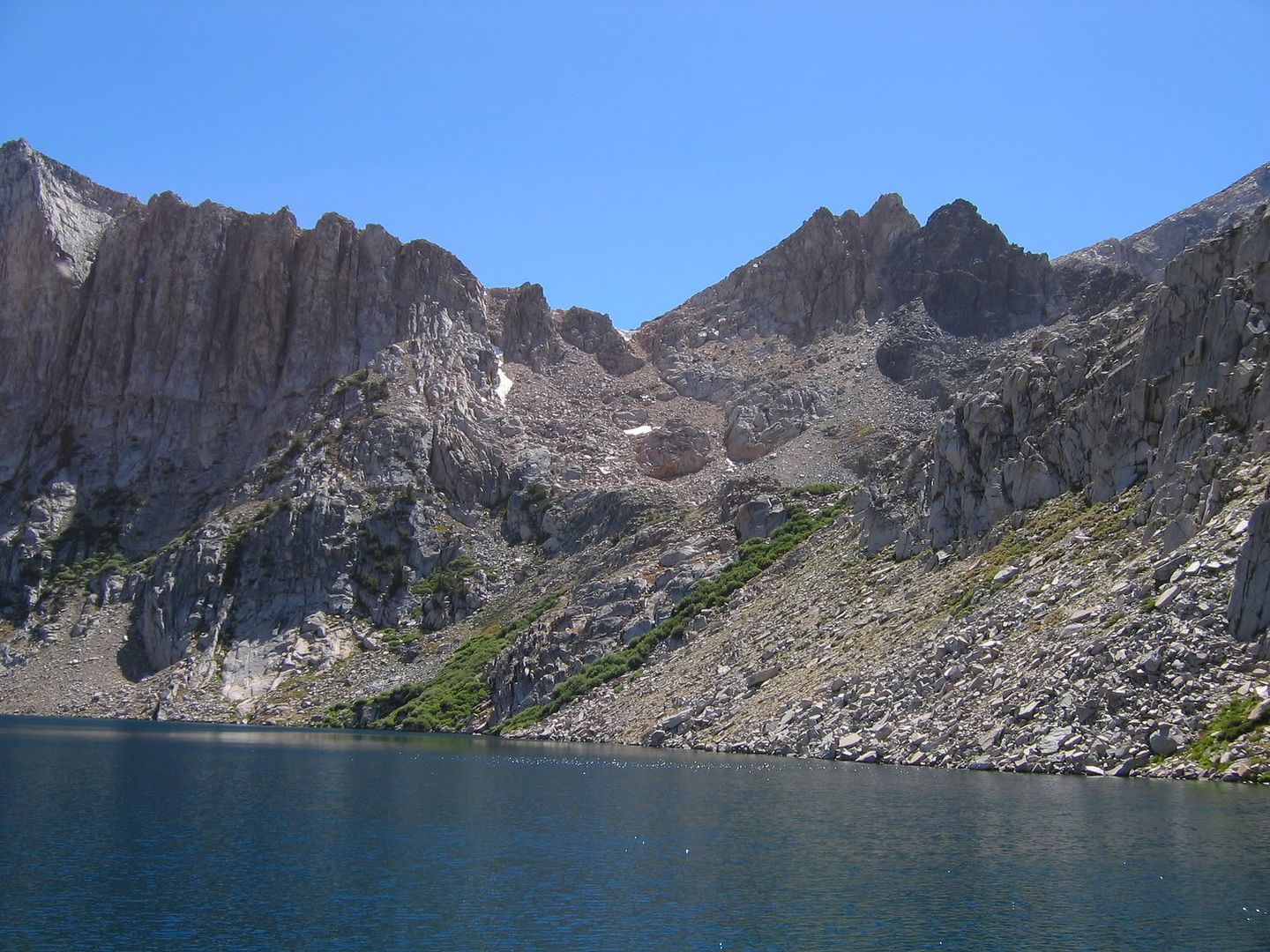
Here is Amph Pass from the top looking down at Amph Lakes. http://wildernessapertures.com/img/s7/v" onclick="window.open(this.href);return false; ... 0083-6.jpg
Maverick, that photo is actually a shot taken from the top of Cataract pass, just above the cornice, on the Dumbell Lakes side of Amphitheater lake. I think TenderPaw was asking about the route from the basin south of Mather Pass over the ridge to Amphitheater Lake. That route looks doable but tricky -- I have always wondered about it. I know it is done in the winter as part of cc skiing expeditions.
Yes Mike your correct, it is Cataract Pass looking at Amph Lake, and the OP later
wrote,
"But when I look at the maps a route like this looks hard/fun/big time adventure;
Kearsarge pass -sixty lakes basin, gardener basin, down to woods creek.
Take woods creek to west to Muro Blanco follow it north to Cartridge Pass.
Lake Basin – Dumbbell Pass and lakes – Amphitheatre Lakes – Cataract Creek"
which is was what I was responding to.
I'm guessing you'll be fine. Your doing your homework and sound no different than I many moons ago. I wasnt and am not a climber, but I love cross country backpacking and haved fared pretty well by just being cautious. IMO, the biggest thing as others have said is to be flexible and have alternatives. If it doesnt look safe, turn around.
I speak from experience on the Amphitheater route you are talking of. I did that hike back in 1980 (give or take a year ) with my brother and friend Tom (CI_Seawolf), but we did not cross Cataract and we had planned to. The pics by Mike & Maverick bring back memories as I have gazed upon both views, but the view from below looked mighty different than in Mikes pics. As JTCarter pointed out, there can be a snow cornice and when we did it, it was freaking massive (no less than 25 feet and likely more). When we got there we basically figured it was impassible. My brother and I dropped our packs and hiked up to it, and found we could access the pass as there was space between the ice and the rock wall that we could get through to access the summit. I as surprised when off in the distance we could see the orange of someones tent between the two western most lakes. As for crossing the pass, we knew it would be quite the trek and would be hard on all of us. We considered it, but Tom basically said "your outta your mind if you think I'm going up that." He was right, it would have been a difficult push with packs for all of us, so we stayed that night and enjoyed the solitude of Amphitheater Lake. The next day we backtracked back to the JMT and hiked to Upper Palisade Lake, the next day to Marion, the next to Twin, and then out over Sawmill (we are primarily fisherman so all of our destinations involved ending by a lake or stram) It was an awesome trip and one I will always remember. The changing the course didnt dampen the mood or the trip one bit.
Once in a while you can get shown the light
In the strangest places if you look at it right.


