If you've been searching for the best source of information and stimulating discussion related to Spring/Summer/Fall backpacking, hiking and camping in the Sierra Nevada...look no further!
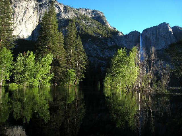
I just got back from Yosemite last night. I did a 3-day trip - Happy Isles to Merced lake up Merced River, back high cut-off trail to John Muir Trail, Panorma Trail to Glacier Point - Four Mile Trail to valley. Snow is not a problem for this route - but there was some major wading. Echo Valley is very flooded. Afternoon water levels more than a foot higher than morning. Little snow still on John Muir Trail. Lots of water in small side streams right now. It was really hot. Merced water levels seem to be coming down a bit. Merced Lake is flooded. The water is less than a foot below the footbridges on the upper Merced River. The Valley is really beautiful now.
Since June 6 all the snow gauges have lost about 10" of snow. That is better than 3" of melt a day.
June 9 readings:
Charlotte Lake 18" (down from 27")
Bishop Pass 41"(down from 51")
Ostrander Lake 27"(down from 37")
Slide Canyon 39" (down from 47")
The streams must be roaring.
At this rate, Charlotte will be clear in a week, while Bishop Pass will take two weeks. All these gauges should be clear before the last week of June. If it stays warm, the next three weeks will have a lot of very dangerous stream crossings.
Mineral King report from Stoney Savage (thabnks, Stoney!):
I went to MK yesterday to survey the situation and had a successful adventure!
The road is open to Disney parking lot and in great shape with the following limitations:
1. Above High Bridge there are a couple minor snow drifts in shaded areas which are currently single lane cleared and will be gone very soon at the current melt rate;
2. Between the cattle guard and the Dixon cabin snow/ice is currently single lane with depth up to 1-3 feet in some areas deepest in the area of Cochrun -- Diseman cabins;
3. The rest of the road is clear of any snow;
4. Monarch Creek is currently overflowing across the road about 50 yards beyond the normal crossing due to the heavy runoff;
5. The bridge at EMK is one lane as it was last fall;
6. There are a couple large puddles along the way in the usual places.
There is lots of snow in the WMK and Faculty Flat area but if the weather stays warm/hot all of the snow will be gone soon! The temperature was a very warm 70+ degrees all day.
The water falls were the largest I've seen in many years!
Just got back 4 days YNP - 2 days Valley and 2 days almost fishing Cherry Lake,
Observations/ impressions Yosemite
...no particular order of importance.
- High water in the Valley crested Tuesday; all the falls are magnificent and total drenching on the Mist trail –indeed something to experience.
- Backpacker camp was 1/3 flooded…the last little bridge (coming in from Stables) was underwater in sections. After 5:00 PM you had to come in from the Ahwahnee (1/2 mile) or Mirror Lake (1 mile), or wade waist deep.
- Out of 50 backpackers met there over 2 nights, maybe 5 were Americans…a lot of German, French, and Israeli…some fun South American guys too.
- The little Mexican Food stand at Curry, next to Mountain Shop, does a great job with dinner, but Curry Cafeteria breakfast, (now $12.50) sort of sucked as compared to last year.
- Still 8 feet of snow where the Tuolumne Store usually stands.
- No PCT’s yet over Donahue.
- Degnon’s Deli is under construction with the addition of an elevator.
- The little trinket shop next to Degnon’s, the one always crowded with cheap bear bric-a-brac now is unexpectedly almost “bare” of most merchandise. (Sorry!)
- The trail up to Merced Lake…last 2 miles underwater – waist deep and full-on rushing…turned back at least 3 parties that I heard of. As the river fluctuates greatly hour by hour, reports early morning access still possible.
- Trail from south to Clouds Rest open with the summit block still under snow…5+ feet snow above 9000 ft.
- Cables on Half Dome still not up.
- HSC’s still expect to open but no hard dates - yet.
- North Dome Trail possible mostly but a lot of snow around the arch still remains…Snow Creek trail OK but muddy.
- There is water everywhere
- Mosquitoes not that bad – yet!
- Gas prices at Crane Flat - $3.29 regular
- Yosemite Valley Art classes @ $5/day…I took two.
- Fishing…since everything high is still ice - We were supposedly all dialed in for Cherry Lake (4800 feet and 20 miles in from 120 entrance), looking for the big browns… trolling with down-riggers. Our own Ozark Flip brought in his small boat with depth finder/everything… pretty tricked out rig. We launched the boat, made the turn out of the inlet north, right into the teeth of the wind. Got wet and scary quick…there will be other days.
- Flip stated, “Some days you are the dog and some days you are the hydrant."
BTW, Flip has a way with words...lots of laughs and stories ...and cold power! Plus, he can cook!
Thanks Flip!
To sum it up about water, right now Yosemite is the big dog and we are all hydrants...waiting?
Just looked at the 4 snow gauges I have been monitoring, and this is what they have done in the last 7 days.
Bishop Pass (11,200) is 36" down from 41". Only 5 inches in a week?
Charlotte Lake (10,400) is 5.5" down from 18". Going fast.
Ostrander Lake (8,200) is 13.5" down from 27". Going fast.
Slide Canyon (9,200) is 29" down from 39".
The melt is going well but the 2nd week in June did not keep up the torrid pace set at the end of the 1st week of June. Bishop Pass in particular is going slow, most other places are losing 1-2 inches a day. I'm heading in at Beehive Meadows later this week and will tell you what I find. I'm expecting things under 8000 feet to be pretty clear, other than shaded areas and northern exposures. But I will find out!
As of June 19, Charlotte and Ostrander gauges are more or less snow free.
Slide Canyon at 9200 is at 18", down from 29" five days ago.
Bishop Pass at 11200 is at 29", down from 36" five days ago.
Yesterday I hiked over Morraine Ridge Trail into Jack Main Canyon. At 8000 feet there was snow in shade and on north faces, but was otherwise clear.
Water. In the Hetch Hetchy area the very worst of the snowmelt has passed and the streams are becoming somewhat more reasonable. 10 days ago the Park Service medivacd a hiker out who was swept away in waist deep water trying to approach the bridge at the Vernon Lake outlet. Now dozens are crossing it on the circuit and not even getting their feet wet. The lake looks to me to be about 2-3 feet above its normal height. Some low lying campsites are underwater. Needless to say, Falls Creek is still extremely impressive and is completely unfordable and uncrossable anywhere except on that bridge--from Jack Main to Vernon and below Vernon. I have seen "rivers" with a lot less water than that "creek".
Recently they opened up the overflow at the Dam and there is a huge waterfall over the cliffs under the day use parking.
Trail conditions are so-so. I had to wade to get down the staircase from the top of Morraine Ridge to Jack Main. Snowmelt had turned the trail into a stream for part of the way. Lots of mud on lots of trails. And the Park service has not yet cleared any of the deadfall from the trails.