Page 2 of 4
Re: Part 2: Aug. 2008 TR: Kaweah Basin, Colby Pass, etc.
Posted: Wed Jul 08, 2009 3:08 pm
by quentinc
CG, I agree -- it's probably unrealistic, and would start to feel like an endurance contest by the 5th or 6th day. I have been seeking a tough (and scenic, of course) 7-8 day trip for September, to try to convince myself I'm not really 50 (despite what the calendar claims), but this might have the opposite effect.
How does one best access Red Spur Basin (which, I assume, is the basin to the northeast of the ridge labeled Red Spur on the map)? I see the southwest ridge is listed as Class 3 in Secor, but I wouldn't be coming at it from that direction. I'm thinking of a 7 day trip at the end of July to Kaweah Basin, probably starting and ending at Wolverton. I figure I can get to Kaweah Basin in 2 days, so am looking for other attractions in the area. Has anyone climbed Picket Guard Peak? Mt. Stewart or Eagle Scout? I'd love to try climbing some of the Kaweahs, but the reputation for loose rock has pretty much killed that idea.
Re: Part 2: Aug. 2008 TR: Kaweah Basin, Colby Pass, etc.
Posted: Wed Jul 08, 2009 4:53 pm
by cgundersen
Hi Quentin,
Maverick (Giantbrookie?) can probably elaborate, since he's been there. On the map, and from my recent visit to Kaweah basin, it looks like one can loop into Red Spur basin from the lower parts of the Kaweah basin (mostly a broad traverse with modest climbing), and this is pretty much what I think Maverick mentioned in another thread. Also, to me, it looked like it would be possible to "hop" directly into upper Red Spur basin by climbing the ridge of the col two "canyons" to the East of Kaweah Pass. I don't have maps handy, but I'll check my wife's photos later and if she has a good shot, I'll post it (though, there may be one already in the mix I posted with my TR from mid-June). Also, Maverick re-iterated that Pyraqueen is the best way into (& out of) Kaweah basin, and after having done Pants/Kaweah Pass, I'd be inclined to agree (I did not "do" Pyraqueen, but it looked far better than Kaweah Pass from the eastern side). Regardless, it's a spectacular area and you'll not regret having time to wander around up there!
CG
Re: Part 2: Aug. 2008 TR: Kaweah Basin, Colby Pass, etc.
Posted: Wed Jul 08, 2009 5:31 pm
by maverick
Start you ascent towards the shoulder above the lake with an island in it in the lower
part of Kaweah Basin well before you reach the lake, go over the shoulder at about
the 11000 ft level.
Mt. Kaweah is an easy stroll from the south (class 1) to the summit.
Eagle Scout has some great views to the west down towards the Hamilton area.
Re: Part 2: Aug. 2008 TR: Kaweah Basin, Colby Pass, etc.
Posted: Thu Jul 09, 2009 1:55 pm
by Mike M.
Q: my favorite way to get into the Kaweahs is via Triple Divide Pass. You can plan a nice 8 day loop trip from the Lodgepole trailhead. Glacier Lake, just below Triple Divide Pass on the west side, is a magical place to camp. It has one of the best views of The Whaleback and Cloud Canyon you will ever see. You can get there in a hard two days or a more reasonable three days depending on your route; that would put you in the Kaweah Basin by Day 4 of your trip. Then explore the basin and loop back to Lodgepole by the cross-country route of your choice (Pyra Queen, Kaweah, or Pants), via the High Sierra Trail and Panther Gap. Depending on how much time you end up spending in Kaweah Basin, Day 8 could end up a long hike.
Another excellent way to get into the Kaweahs is via Milestone Pass. This gives you the option of three east side approaches, Kearsarge, Shepherd, or New Army. A nice loop might be Kearsarge to Vidette to Center Basin over Junction Pass over Shepherd Pass to Tyndal Creek to Milestone Basin over Milestone Pass to Kaweah Basin, to upper Kern, to Tyndal Creek, over Forester and out Kearsarge. For me, that is more like a 10 day loop, but if you skipped Junction Pass and went over Forester instead, you could easily do this in 8 days.
Shepherd Pass from the valley floor is more direct but I hear it can be a ball buster. How'd they get kayaks up there??
I'm sure one of the things that attracts us to the Kaweahs is how remote they are -- it's hard to dash in and dash out, unless you're Bob Burd!
Mike
Re: Part 2: Aug. 2008 TR: Kaweah Basin, Colby Pass, etc.
Posted: Thu Jul 09, 2009 2:29 pm
by cgundersen
Mike & Quentin,
As I mentioned before, I like Triple Divide Pass, too (though, frankly, I like the "mini-Glacier Lake" at the top of Cloud Canyon better than Glacier Lake itself). One word of caution if you choose that route: once you cross (W to E) the pass, follow the gentlest contours around the ridge south of the pass and aim to wind up in the "permanent" snowfield almost due south of the pass. From there you can get down to the lake (at ~10,200) at the upper reaches of the Kern-Kaweah river. Otherwise, getting off the plateau to the East of Triple Divide Pass can be hairy. I tried to find another way down from above and the further East I went, the worse it looked. It looks no better from below, so if there's a way, it's not obvious (unless you're packing ropes).
CG
Re: Part 2: Aug. 2008 TR: Kaweah Basin, Colby Pass, etc.
Posted: Thu Jul 09, 2009 9:37 pm
by Mike M.
CG:
Is that the tiny lake just below Lion Pass?
Yes, getting down from Triple Divide Pass is always an adventure. I've tried several routes; none are easy or obvious, and all involved me handing my pack down by nylon cord a few times. I have never done it east to west, but I would guess it would be easier to find a route going up as opposed to going down.
Mike M.
Re: Part 2: Aug. 2008 TR: Kaweah Basin, Colby Pass, etc.
Posted: Thu Jul 09, 2009 10:52 pm
by quentinc
Guys, thanks much for all the ideas. I'll have to go study the map! For some perverse reason I've always liked the hike up to Shepherd Pass, so I was considering that as an alternative route.
Maverick -- I noticed Secor listed Kaweah as Class 1 from the south, but the approach hike south around the whole basin doesn't look very appetizing on the map. Have you done it?
Re: Part 2: Aug. 2008 TR: Kaweah Basin, Colby Pass, etc.
Posted: Fri Jul 10, 2009 2:28 pm
by cgundersen
Hi Mike & Quentin,
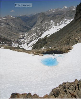
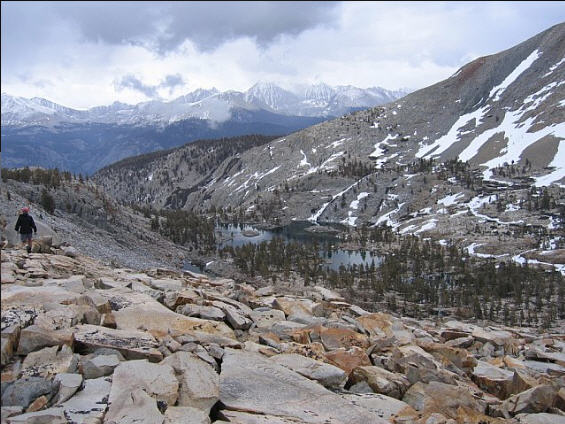
Yes, the lake I'm referring to is the tiny dot (on the topo map) at the upper end of Cloud Canyon, just below Lion Pass. I'll try to post a couple of old pictures below. Also, my wife got a shot of the lower lakes in Kaweah basin, and it's pretty clear from the photo that traversing around to Red Spur basin (by ascending the ridge to the right of the lakes) is pretty straightforward! CG
Little Lake above Cloud Canyon:
[img=
http://www.flickr.com/photos/10845599@N03/3708158718/]
http://farm3.static.flickr.com/2455/370 ... 16e7_o.jpg[/img]
Little Lake at the upper end of Cloud Canyon: View up to Lion Pass:
[img=
http://www.flickr.com/photos/10845599@N03/3708158664/]
http://farm3.static.flickr.com/2561/370 ... 3c08_o.jpg[/img]
And, the view of the lakes at the low end of Kaweah Basin:
[img=
http://www.flickr.com/photos/10845599@N03/3707349037/]
http://farm3.static.flickr.com/2357/370 ... d790_o.jpg[/img]
Re: Part 2: Aug. 2008 TR: Kaweah Basin, Colby Pass, etc.
Posted: Fri Jul 10, 2009 2:57 pm
by maverick
Hi Q
Yes, I have.
You would do this from the Big Arroyo side not from inside Kaweah Basin, unless
of coarse you were going to use Kaweah Pass as an entrance or exit from/into the
basin and then do the climb at that time as a side trip.
Re: Part 2: Aug. 2008 TR: Kaweah Basin, Colby Pass, etc.
Posted: Fri Jul 10, 2009 6:42 pm
by Mike M.
CG: that's a pretty lake -- downright dainty!
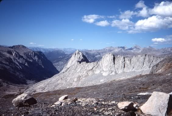
Here is the view of The Whaleback from Glacier Lake, just below Triple Divide Pass, that I like so much. (Sorry about the bad slide scan.)
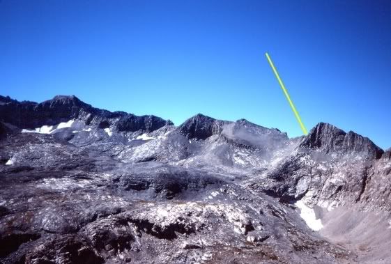
And a view of Pants Pass from Triple Divide Pass, with the yellow line pointing to Pants Pass:
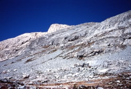
And finally, a view of the steep ridge you have to pass through to get down to the upper Kern-Kaweah watershed from Triple Divide Pass. After several trial and errors over various seasons, including working my way down a steep creekbed one year, I think the ridge shown here is the best alternative. It just takes time and patience.
Mike