Page 2 of 4
Re: TR: Kaweah Basin June '09
Posted: Thu Jun 18, 2009 5:52 pm
by Mike M.
TehipiteTom wrote:Dang Mike M, I'm getting vertigo just looking at those pics.
Or maybe it's just been a long time since lunch, and I'm dizzy from hunger. Maybe both.

Yeah, I'm not real comfortable with heights, and this is one pass right on the edge of my comfort level!
My first time up in 1975, I was guided by a girlfriend who knew the route from a previous visit. It's only the last 30 feet or so that has any exposure, and this is bypassed completely if you are willing to fuss around in the loose chute. We chose to move to the rock, not look down, and keep on moving . . . . I'm sure it's not as exposed as it looks, else I would have **** my pants!
Re: TR: Kaweah Basin June '09
Posted: Thu Jun 18, 2009 6:10 pm
by markorr
treadwell wrote:
I'm sensing a requirement for a "car cannister" in my future....

Wouldn't that be a carsized Marmot Canister (TM)?
Re: TR: Kaweah Basin June '09
Posted: Thu Jun 18, 2009 7:42 pm
by Shawn
Great TR and photos (crazy wx) - thanks for posting.
Re: TR: Kaweah Basin June '09
Posted: Fri Jun 19, 2009 12:35 pm
by quentinc
CG, I'll add my voice to the multitude of thanks. I was particularly interested since I'm considering a trip to Kaweah Basin this September.
Maverick -- thanks for the tip that Pyra-Queen is the easiest entry.
For those who have done this trip, would you recommend starting from Wolverton or MK (assuming the marmots are full by September)? I had my eye on approaching 9 Lake Basin from Glacier Pass and Black Rock Pass.
Re: TR: Kaweah Basin June '09
Posted: Fri Jun 19, 2009 1:02 pm
by maverick
To me the Crescent Meadow approach is the quickest using the freeway known
as the HIgh Sierra Trail.
If you take off early enough you can make Nine Lakes Basin in a day, though in
September the days are shorter so you could probably make it to Hamilton.
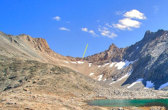
Queen-Pyra is the small chute in the middle of the ridge going from left to right above
the snow patch.
http://maverick.zenfolio.com/img/v6/p707623398-5.jpg" onclick="window.open(this.href);return false;
Re: TR: Kaweah Basin June '09
Posted: Fri Jun 19, 2009 7:43 pm
by quentinc
Maverick, thanks for posting the picture. Do you mean the tiny notch just to the right of that small pyramid type outcropping? (Or is that an incredibly stupid question given that the name of it is
Pyra-Queen?)
I've never backpacked out of the main part of Sequoia, and am not sure I like that "freeway" description!

I have been over Black Rock Pass to Little and Big 5 Lakes, and that route is pretty nice.
Re: TR: Kaweah Basin June '09
Posted: Fri Jun 19, 2009 7:53 pm
by copeg
quentinc wrote:For those who have done this trip, would you recommend starting from Wolverton or MK (assuming the marmots are full by September)? I had my eye on approaching 9 Lake Basin from Glacier Pass and Black Rock Pass.
I'd agree with maverick that Crescent Meadow is probably the quickest approach. I'd say Mineral King has a lot of potential sidetrips that - if Kaweah is your main goal - could also slow a hiker down quite a bit. I've hiked towards Kaweah from Shepherds Pass, Roaring River, and Crescent Meadow and of those routes Crescent was by far the fastest.
Re: TR: Kaweah Basin June '09
Posted: Fri Jun 19, 2009 10:44 pm
by maverick
Hi Q
Look at the ridge in the middle and you'll see that area that looks like sand and
follow that up and then to the left you see that snow patch starting, look above
that and you see a tiny sliver of "sand" at an angle going from left to right.
By the way "freeway" was meant as it being very moderate in elevation gain which
is great for going fast at least till Bearpaw Meadow, not the human traffic.
Re: TR: Kaweah Basin June '09
Posted: Sat Jun 20, 2009 10:22 pm
by quentinc
Thanks Maverick -- that makes more sense that what I was looking at.
The HST does look easier than Mineral King with its two passes. But 9 Lakes Basin in a day --
what's that, 18 miles and 4000 foot gain? I think my days of doing that are behind me.
Re: TR: Kaweah Basin June '09
Posted: Sun Jun 21, 2009 10:40 pm
by Mike M.
Maverick:
Thanks for posting the excellent photo of Pyra-Queen Col. I assume this was taken from Kaweah Basin. Is that correct? I had a hard time following your written route description. Does the yellow line in the photo below point to the col?
Mike