TR: Kaweah Basin June '09
Posted: Thu Jun 18, 2009 10:55 am
First, here's the photo link (on flickr):http://www.flickr.com/photos/10845599@N03/
And, here's the long-winded description:
Kaweah Basin Trip
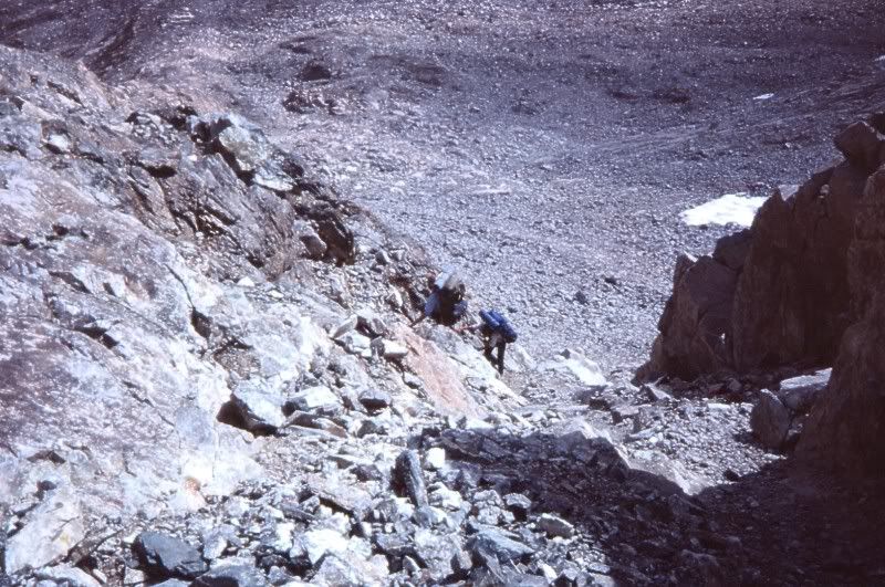
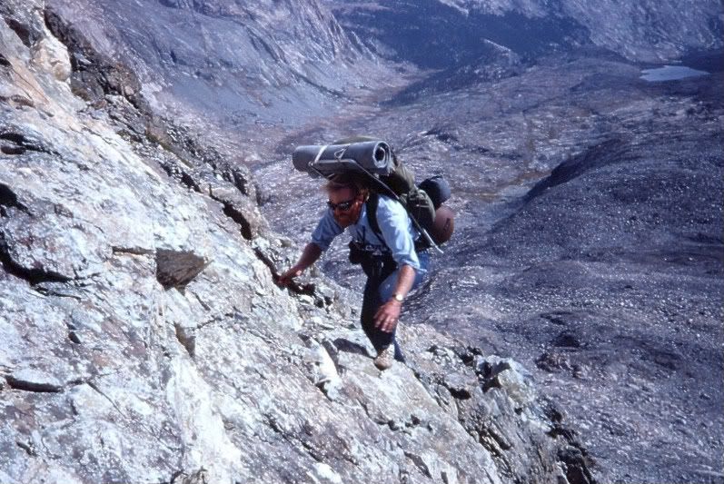
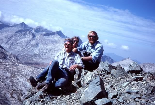
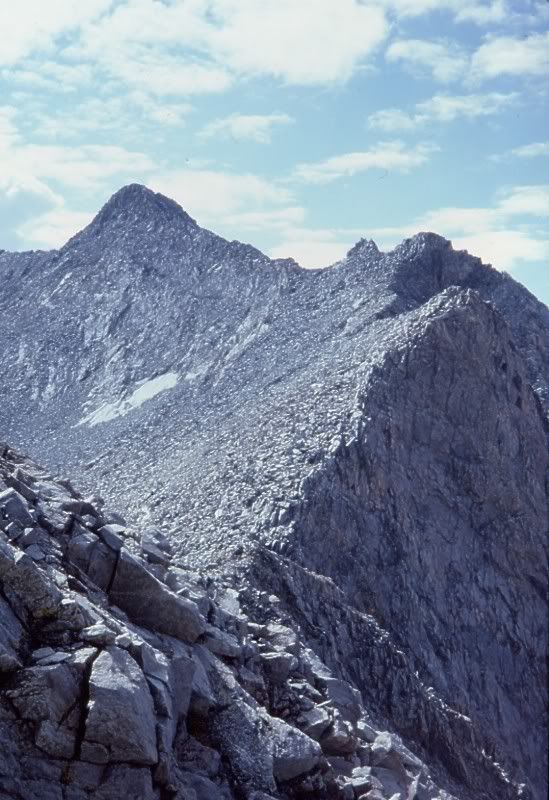
Having visited 9 Lakes Basin on my first Sierra backpack (in the early ‘70s), I’d always wondered what the other side of the Kaweahs was like (and this interest was fueled by other folks on this site!). Four years ago, my wife & I were aiming for the backside of the Kaweahs (by looping in from the North via Triple Divide Pass), but with heavy snow on an early June trip, we did not get beyond the headwaters of the Kern-Kaweah River. This time, we planned to go over Sawtooth Pass (and head in via Pants Pass or Kaweah Pass, whichever looked better), but on the appointed day, we encountered a few obstacles. First, a fallen tree blocked the Mineral King road (fortunately, two rangers arrived 5 min after we did and the delay was minimal). Second, we were told by the very helpful ranger issuing wilderness permits that her boss had been reluctant to descend the far side of Sawtooth a couple days earlier even though he had an ice axe and crampons (too icy; we had neither). Third, the marmot problem has apparently gotten worse, and folks are encouraged to bring full wraps or fences for their vehicles (we had neither). Fourth, by the time we got our permit, it was raining/hailing and there were sporadic bursts of thunder (too grey to see lightning, if there was any). We aborted, stayed overnight and got an early start the next morning at Wolverton. The weather held till Hamilton Lake and though we’d wanted to try for Precipice Lake, the clouds were just beginning to obscure Kaweah gap, so we parked at Hamilton. The next two days had a mix of every imaginable form of precipitation with the most impressive being an inch of hail and ~4 inches of snow. We almost hit trail at midday on our second day, but the transient clearing was just that, transient. Had it not cleared on day 4, we were going to bolt. But, day 4 started with brilliant sunshine and by mid-morning we hit solid snow about 300 ft below Precipice Lake and carved fresh tracks to Kaweah gap. Not surprisingly, there was little exposed ground in 9 Lakes Basin, but we found a campsite at the lake below Pants Pass just before the clouds reduced visibility to less than 10 ft. The next morning was gorgeous with warm sun (and billowing clouds in the distance), so after giving just enough time to let the snow thaw a bit we tackled Pants Pass. The west side was pretty benign, but the first ~100 ft on the East side was close to vertical, and the entire chute was coated with snow. The scenery helped quell my wife’s initial reluctance to go down and after some semi-tricky maneuvering on the top third, we got to glissade the rest. I have a hunch that Pants is appreciably harder in August, but for us it was a thrill! Unfortunately, we got two more days of miserable weather in the upper reaches of the Kern-Kaweah basin before finally being able to climb a saddle into Picket Guard basin. Even so, we got pelted by hail and snow as we reached the lower end of the basin. Nevertheless, the mini-hump into Kaweah basin was a stone’s throw away, so even when the next day opened with a winter grey sky, we hit the road. And, during the rest of the day, the sun broke through occasionally, so we could appreciate (a little) everything we’d heard about the area from Maverick, Greg (Trailblazer) and others. Yes, Kaweah basin is splendid, and our only regret is that the time we’d hope to have to wander around the basin was spent waiting out storms earlier in the trip. In spite of this, the best weather of the trip arrived the next morning, so we waited till about midday before starting our ascent of Kaweah Pass. I think that a few of the photos my wife took begin to capture some of the splendor, but the awful weather precluded any alpenglow and some of the subtler lighting effects that will make a return trip necessary. Anyway, Kaweah Pass is much more challenging than I expected it to be. The rocks that I’d been longing for during the seemingly interminable snow ascent turned out to be miserably jumbled and loose. Hence we made a very slow and cautious creep up the final ~150 ft. Fortunately, the packs were a lot lighter at this stage of the trip. Anyway, the lake that sits at ~12,400 ft (below Mt. Kaweah) was completely enshrouded in snow, as was the first several hundred feet of our descent to Chagoopa plateau. We camped by one of the small, high lakes as the early morning sunshine segued to a steel grey. It was the only day of the trip with no precipitation. The next morning came with high clouds that kept descending until we met them in the upper Big Arroyo. By mid-afternoon, the cloud bank was dense enough that it seemed that nightfall was imminent. Still, we managed to dust off a campsite below Kaweah gap and in freezing sleet packed up the next morning and reached Wolverton by early evening. During the drive down to Three Rivers the alpenglow on Moro Rock and Castle Rocks was spectacular. It was the only alpenglow of the whole trip. Still, as the saying goes, any day in the Sierras beats the best day in LA………(or the office). The final tidbit is that we “rescued” two balloons on the trip, but the third one was a shiny blue mylar star that we left near where we found it in Kaweah basin. My wife wants to see if it’s still there the next time we visit the area. I’m guessing it won’t last that long. On the other hand, it’s a BIG basin! And, it's worth the effort to get there!
CG
And, here's the long-winded description:
Kaweah Basin Trip
Having visited 9 Lakes Basin on my first Sierra backpack (in the early ‘70s), I’d always wondered what the other side of the Kaweahs was like (and this interest was fueled by other folks on this site!). Four years ago, my wife & I were aiming for the backside of the Kaweahs (by looping in from the North via Triple Divide Pass), but with heavy snow on an early June trip, we did not get beyond the headwaters of the Kern-Kaweah River. This time, we planned to go over Sawtooth Pass (and head in via Pants Pass or Kaweah Pass, whichever looked better), but on the appointed day, we encountered a few obstacles. First, a fallen tree blocked the Mineral King road (fortunately, two rangers arrived 5 min after we did and the delay was minimal). Second, we were told by the very helpful ranger issuing wilderness permits that her boss had been reluctant to descend the far side of Sawtooth a couple days earlier even though he had an ice axe and crampons (too icy; we had neither). Third, the marmot problem has apparently gotten worse, and folks are encouraged to bring full wraps or fences for their vehicles (we had neither). Fourth, by the time we got our permit, it was raining/hailing and there were sporadic bursts of thunder (too grey to see lightning, if there was any). We aborted, stayed overnight and got an early start the next morning at Wolverton. The weather held till Hamilton Lake and though we’d wanted to try for Precipice Lake, the clouds were just beginning to obscure Kaweah gap, so we parked at Hamilton. The next two days had a mix of every imaginable form of precipitation with the most impressive being an inch of hail and ~4 inches of snow. We almost hit trail at midday on our second day, but the transient clearing was just that, transient. Had it not cleared on day 4, we were going to bolt. But, day 4 started with brilliant sunshine and by mid-morning we hit solid snow about 300 ft below Precipice Lake and carved fresh tracks to Kaweah gap. Not surprisingly, there was little exposed ground in 9 Lakes Basin, but we found a campsite at the lake below Pants Pass just before the clouds reduced visibility to less than 10 ft. The next morning was gorgeous with warm sun (and billowing clouds in the distance), so after giving just enough time to let the snow thaw a bit we tackled Pants Pass. The west side was pretty benign, but the first ~100 ft on the East side was close to vertical, and the entire chute was coated with snow. The scenery helped quell my wife’s initial reluctance to go down and after some semi-tricky maneuvering on the top third, we got to glissade the rest. I have a hunch that Pants is appreciably harder in August, but for us it was a thrill! Unfortunately, we got two more days of miserable weather in the upper reaches of the Kern-Kaweah basin before finally being able to climb a saddle into Picket Guard basin. Even so, we got pelted by hail and snow as we reached the lower end of the basin. Nevertheless, the mini-hump into Kaweah basin was a stone’s throw away, so even when the next day opened with a winter grey sky, we hit the road. And, during the rest of the day, the sun broke through occasionally, so we could appreciate (a little) everything we’d heard about the area from Maverick, Greg (Trailblazer) and others. Yes, Kaweah basin is splendid, and our only regret is that the time we’d hope to have to wander around the basin was spent waiting out storms earlier in the trip. In spite of this, the best weather of the trip arrived the next morning, so we waited till about midday before starting our ascent of Kaweah Pass. I think that a few of the photos my wife took begin to capture some of the splendor, but the awful weather precluded any alpenglow and some of the subtler lighting effects that will make a return trip necessary. Anyway, Kaweah Pass is much more challenging than I expected it to be. The rocks that I’d been longing for during the seemingly interminable snow ascent turned out to be miserably jumbled and loose. Hence we made a very slow and cautious creep up the final ~150 ft. Fortunately, the packs were a lot lighter at this stage of the trip. Anyway, the lake that sits at ~12,400 ft (below Mt. Kaweah) was completely enshrouded in snow, as was the first several hundred feet of our descent to Chagoopa plateau. We camped by one of the small, high lakes as the early morning sunshine segued to a steel grey. It was the only day of the trip with no precipitation. The next morning came with high clouds that kept descending until we met them in the upper Big Arroyo. By mid-afternoon, the cloud bank was dense enough that it seemed that nightfall was imminent. Still, we managed to dust off a campsite below Kaweah gap and in freezing sleet packed up the next morning and reached Wolverton by early evening. During the drive down to Three Rivers the alpenglow on Moro Rock and Castle Rocks was spectacular. It was the only alpenglow of the whole trip. Still, as the saying goes, any day in the Sierras beats the best day in LA………(or the office). The final tidbit is that we “rescued” two balloons on the trip, but the third one was a shiny blue mylar star that we left near where we found it in Kaweah basin. My wife wants to see if it’s still there the next time we visit the area. I’m guessing it won’t last that long. On the other hand, it’s a BIG basin! And, it's worth the effort to get there!
CG