Page 1 of 3
Is This Rancheria or Crown Valley Trailhead?
Posted: Wed Feb 01, 2006 3:42 pm
by krudler
Hi great people,
Ok so this year, for the 3rd year in a row, I am "planning" on making an epic 1-week trip in early Oct to the awesome Tehipite Valley to flyfish the M.Fork Kings. I keep saying I'm going to get there, but each year when the time rolled around for one reason or another I couldn't (or didn't) actually go. I swear this year will be different!
Anyhoo, I'm trying to plan out my route and have settled on the option pictured below (only beginning of the route pictured) - although this could change based on new info. The million dollar question is this: Which trailhead would that be? Rancheria or Crown Valley? I hear that Rancheria is a somewhat "easier" (less elevation gain) although slightly longer route. Since I think the route I plotted out is the "shortest", based on what I can see on the topo, I assume it is Crown Valley - however this may not be accurate so I am trying to confirm what I am looking at here.
Wishon Res. is in the upper left corner of the map:

While I'm just looking for some confirmation on what trailhead that is, any info on the actual trail or the valley (esp. the fishing) is always welcome...however I think I have already gotten alot of that from some of you in previous years!
Thanks much for your collective expert assistance!!!
--dan.
Posted: Wed Feb 01, 2006 5:43 pm
by giantbrookie
I actually don't know what each of these trailheads are called ('officially'), but the one you have highlighted is the lower elevation (<7000' elev) trailhead. I hiked out of that one to go to Spanish Lakes in the past. I too am planning to hike out of this area at least once this year (first to the Geraldines, then, possibly to Tehipite to kick off a megatrip) and I don't plan to use that lower elevation trailhead. The one they call Rancheria may be one of those several parallel roads near Little Rancheria Creek. I do not know what the access issues on those are, specifically, but the lowest of them is 7600'+ so you're starting >600' higher at minimum. I would think that the higher one would be the preferred route given that you aren't going to adding that much extra distance (none if you're able to use the middle elev. one).
Posted: Wed Feb 01, 2006 8:28 pm
by Buck Forester
The one I start at is the Rancheria Trailhead, which I do believe is the one depicted in your map, but I mostly use the Tom Harrison maps because they're updated and the old USGS ones have changed so much. There's a large, obvious trailhead there but most aren't there for Tehipite Valley. I go every late May/early June and I have never seen another person down there. It's truly amazing to have such an incredibly stunning and massive valley to yourself. Well, you share it with the rattlesnakes.
Here's some links to some images from my trips in there:
http://gallery.photo.net/photo/2415446-lg.jpg
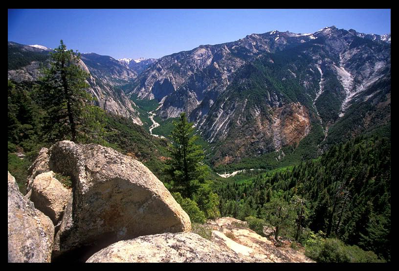
M.F. Kings River just north of where Crown Creek comes in. Wide-angle shrinks the perspective (peaks).
http://gallery.photo.net/photo/2623291-lg.jpg
Crown Valley Creek below Silver Spray Falls. The base of the falls are in the distance of this shot, but it's too misty there to really see them from this angle.
http://i13.photobucket.com/albums/a259/ ... bsmall.jpg
A snapshot of Tehipite Valley as you being your steeeeep descent on the trail.
http://i13.photobucket.com/albums/a259/ ... csmall.jpg
Zoomed in on Tehipite Valley a little more from the same perspective. That's Tehipite Dome on the left, which doesn't look so domey from above, but when you're in the valley it's like Half Dome.
http://i13.photobucket.com/albums/a259/ ... bsmall.jpg
Bear claw marks on a tree along the lonely trail beyond Crown Valley.
http://i13.photobucket.com/albums/a259/ ... bsmall.jpg
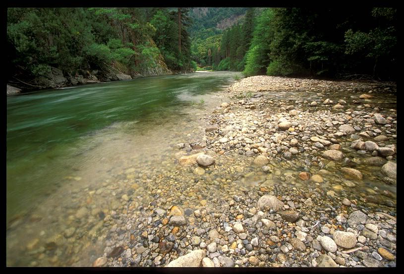
The crystal clear M.F. Kings in the middle of Tehipite Valley. I hooked a very large trout on a big spoon right here but lost it.
http://i13.photobucket.com/albums/a259/ ... bsmall.jpg
Another shoot looking across the wild M.F. Kings River. This was in early June so obviously in October you'll be able to easily walk across the river here.
I've got a bazillion photos and I'll be putting them up on my website, whenever that may be! Hopefully I'll be in this magical place again in about three weeks!
Posted: Wed Feb 01, 2006 8:40 pm
by Buck Forester
A couple more...
http://www.photo.net/photodb/photo?phot ... 22&size=lg
Tehipite Dome towering over the valley. Again, this is a wide angle lens to fit it into the image. In real life it's even higher.
http://www.photo.net/photodb/photo?phot ... 36&size=lg
Hidden pictographs (or petroglyphs? I get them mixed up!) on Painted Rock.
http://www.photo.net/photodb/photo?phot ... 88&size=lg
Looking up at Tehipte Dome.
It's the promised land! This Buck deerly loves this place.
Posted: Wed Feb 01, 2006 8:52 pm
by krudler
Absolutely AWESOME, Buck!

Wow, in 3 weeks? A crazy winter trip? You'll have to report back on that one. Are you going to snowshoe or XC ski , or posthole it? I assume there must be snow?
Posted: Wed Feb 01, 2006 9:00 pm
by Buck Forester
Well, the plan is to snowshoe to Yucca Point in Kings Canyon, crank down into one of the deepest gorges in North America to the confluence of the M.F. and S.F. Kings Rivers, then hike up the wild, trailess M.F. Kings River (often in the river itself, with wetsuits) to Tehipite Valley. I'm not sure it's doable, it depends on water levels. Yes, there will be snow and fuh-reezing water. It'll be epic trying to get up there via this route.
Posted: Wed Feb 01, 2006 9:21 pm
by krudler
Best of luck! That is hard-freaking-core!!!
Posted: Wed Feb 01, 2006 11:44 pm
by SSSdave
Buck Forester wrote:Well, the plan is to snowshoe to Yucca Point in Kings Canyon, crank down into one of the deepest gorges in North America to the confluence of the M.F. and S.F. Kings Rivers, then hike up the wild, trailess M.F. Kings River (often in the river itself, with wetsuits) to Tehipite Valley. I'm not sure it's doable, it depends on water levels. Yes, there will be snow and fuh-reezing water. It'll be epic trying to get up there via this route.
Your joking of course.

You'd never survive trying to cross the South Fork. The road into Kings Canyon is often open by mid May or Memorial Day. There are some fine late spring wildflowers along that road I've been to a few years about then. The South Fork of the Kings in early June still has a huge and violent flow. This year the snowpack in that part of the Sierra is well above normal. I have Kodachromes looking down from Yucca Point at the confluence taken during one of last decade's El Nino years.
...David
Re: Is This Rancheria or Crown Valley Trailhead?
Posted: Thu Feb 02, 2006 12:02 am
by SSSdave
krudler wrote:... The million dollar question is this: Which trailhead would that be? Rancheria or Crown Valley? I hear that Rancheria is a somewhat "easier" (less elevation gain) although slightly longer route. ...
--dan.
Might phone the district ranger station then ask to have the person on the other end to find out the definitive information so when you phone back you'll get the right info. Might be stable trailhead situation now. However the end of road access in areas east of the Wishon dam have changed a few of times because of logging and cattle grazing going on. In 2000 four of us drove to the end of that road on your map shown northwest of Hoffman Mountain with "restricted access" (blocked at gate at north bend) and I did a crosscountry north of the mountain in a cheater route towards reaching Pearl and then Martha. ...David
Posted: Thu Feb 02, 2006 8:49 am
by giantbrookie
Regarding the Rancheria trailhead, I checked my JMWilderness/Seki topo which has the more recent trails and cultural features on it and it has the <7000' elev. trailhead (the one highlighted) labeled as "Crown Valley" and the trailhead and where that northern trail takes off on your map (at just below 7640 and just west of a labeled spring) as "Rancheria".
Ditto Dave's comment on the S.Fork Kings early season. Even far upstream, one of the main tributaries of the S. Fork, Bubbs Creek, has claimed lives at the notorious Junction Meadow crossing during the early season (I myself crossed Bubbs at Jct Mdw. under dangerous conditions there on Memorial Day weekend 1979--a low snowfall year at that).