Page 3 of 5
Re: Obelisk Lake Route Questions
Posted: Sat Mar 28, 2009 12:24 pm
by oldranger
maverick,
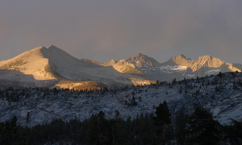
Thanks for the photo. It is amazing how much the mind forgets over 40 years! I assume that is a view down long creek. I've been up it once and down it once and don't remember it being that rough. First time was down it after hiking up Bench Canyon with my dad in the early 60s. Second time was 69 with my ex on a trip that ended in Yosemite Valley. Everytime I took her on a trip she said "I'll never go there again." So I had to keep taking her to different places. Now my true love refuses to go if I plan cross country trips. So I have to sneak cross country up on her or go with the kids or solo.
hope we cross paths
Mike
Re: Obelisk Lake Route Questions
Posted: Sat Mar 28, 2009 1:57 pm
by TehipiteTom
Maverick, I hope it works out--it would be great to meet you!
Re: Obelisk Lake Route Questions
Posted: Sun Jul 26, 2009 7:58 am
by TehipiteTom
markskor wrote:Just got a PM from this perky youngster...named Tehipite Tom…still wet behind the ears it seems. Anyway, the way it now looks is that all three of us (myself, OldRanger, and TT), are planning joining forces for what promises to be an epic summer journey. The Adair, Obelisk X-country route…meeting up mid July, 15 miles in, at Red Devil, Etna, or someplace close to… with 6 other lakes thrown in for good measure …figure 10 – 13 days of fishing. Who knows where we will eventually end up, or what damage we three can do to Yosemite.
Best part is that TT volunteered to carry all the heavy gear, as he brags about his being so much younger. Watch out Sierra, here we come.
Mark
Well, we did it: we actually met up where and when we planned to! Spent the next couple days exploring some out-of-the-way corners of Yosemite. Great trip, great company. More later; for now, I'll leave y'all with a shot from near the outlet of Adair Lake after a late afternoon thunderstorm.
Edit: by the way, I did do the Obelisk-to-trail route shown in the original post in this thread...made a couple of bad choices along the way, but on the whole it worked out really well.
Re: Obelisk Lake Route Questions
Posted: Wed Jan 04, 2012 8:39 pm
by norcalhiker
Tom, which Obelisk to trail route did you end up doing? The third one? Slab? Cavalry?
I'm actually toying with the idea of heading up there this weekend from Happy Isles.. In January

Re: Obelisk Lake Route Questions
Posted: Thu Jan 05, 2012 9:15 am
by oldranger
NCH
Tom can describe his route, markskor and I followed the drainage down to the steep cascade then skirted n. and worked our way down various user/deer trails, and through brush and across slabs. A couple of hundred feet from the bottom we realized we were on the now brush covered cavalry trail (a clearly constructed trail with switchbacks). We lost it at the very bottom. Obelisk, though beautiful, is one place I will not return to (no fish!).
Mike
Re: Obelisk Lake Route Questions
Posted: Thu Jan 05, 2012 10:28 am
by markskor
Drew up our successful route on the HST Map...
Look under "Trails not maintained"
Red Devil drainage in dark blue/purple.
FYI, tried this lake twice. Once up from Merced Lake and got cliffed out - picked wrong canyon - sigh,
and once down from Red Devil with the boys (TT and OldRanger) - one hellaciously great trip - we all made it to Obelisk too, split off there - Tom went one way and Mike and I another, but,
The last few miles down to Merced River consisted, as Mike said, solid Manzanita walls and very steep.
Alas after 2 years of planning, (FYI, this route was featured in BackPacker mag - "Old Calvary Trail... supposedly stocked a century before...bla, bla, bla") there was no visible trail found, and there were no fish seen in Obelisk.
Mark
Re: Obelisk Lake Route Questions
Posted: Thu Jan 05, 2012 3:32 pm
by TehipiteTom
norcalhiker wrote:Tom, which Obelisk to trail route did you end up doing? The third one? Slab? Cavalry?
I'm actually toying with the idea of heading up there this weekend from Happy Isles.. In January
From Obelisk to the trail I did pretty much the solid red line route [EDIT: see my map earlier in the thread] (over the saddle north of Obelisk, drop to ~8700, traverse west into Clark Canyon, drop to the trail below Echo Valley). It went beautifully, for the most part; if you find the right level for the traverse (which should be fairly obvious going up), everything else is pretty clear.
Re: Obelisk Lake Route Questions
Posted: Thu Jan 05, 2012 5:09 pm
by DoyleWDonehoo
Thank you all for bringing up this thread! Every time I went over Red Peak Pass, I looked longingly over to that imagined route to Adair Lake (and the lake to the east), and poured over maps countless times wondering if it was do-able, and not cut off by cliffs or something. And here I find out it is possible! That's outstanding! And pictures here to boot. Awesome. Old Ranger, if you have mapped that route I sure would like to see it. It looks obvious, but verification is always nice. Great thread!
Re: Obelisk Lake Route Questions
Posted: Thu Jan 05, 2012 6:12 pm
by rlown
it's not intuitive where to look for "trail not maintained". If you use the search feature, you get jack.
You have to know where the map pointers are:
viewtopic.php?f=1&t=6960" onclick="window.open(this.href);return false;
The other map SW is on the compose message page, but not the HST map..
you have to go to
http://www.highsierratopix.com/high-sierra-map/map.php" onclick="window.open(this.href);return false; and then do your "search map"..
just to be clear.. Mark, at least you gave a pointer.
Russ
Re: Obelisk Lake Route Questions
Posted: Thu Jan 05, 2012 8:13 pm
by DoyleWDonehoo
markskor wrote:Drew up our successful route on our own HST Map here...Old Ranger, TT, and myself -Look under "Trails not maintained routes"
I checked that out and it does have possibilities, but it is not the same route that oldranger used in about post 12 with pictures in this thread, the one I am interested in, which comes in above Adair Lake (while the above map route comes in from below). No matter, I have a very good idea of the route anyway, and really, the lower route may be better. Thanks!
(It just occurred to me: my picture avatar to the right was taken at Red Peak Pass.)