
Day 1: Onion Valley to Kearsarge Lakes via Kearsarge Pass
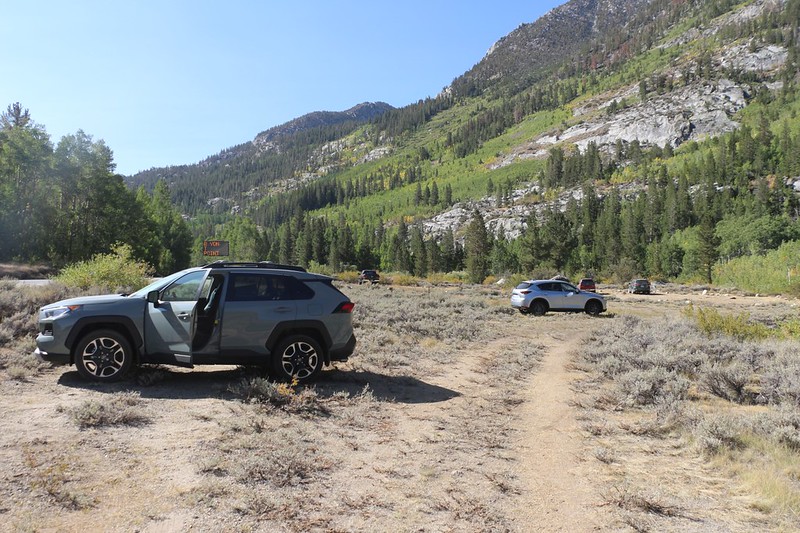
We drove up to Bishop from San Diego a day early, then spent the night near the trailhead. It turned out that South Lake Road had been under construction all Summer, so they made the overnight hikers park way down past the Tyee Lakes Trailhead. The dirt lot on the side of the road was packed with cars. This issue meant that we would have to hike three extra miles after getting to South Lake, in order to reach the car. But it was just another annoying item that 2020 had dealt us, so we made do. This was nothing compared to Covid and the wildfires.
The next morning, Owens Valley was full of smoke. Well, we still weren't going to quit, and we hoped that there would be less smoke up at higher elevation. So we left one car up north and headed south in the other. My wife had volunteered to help with the shuttle, and so she dropped us off at Onion Valley and headed home - Thanks! Luckily for us, the air already seemed clearer up there.

My son and I at the Kearsarge Pass Trailhead in Onion Valley

Looking east over Gilbert Lake and the big boulder - you can see how the smoke is rising up from Owens Valley

After climbing above Heart Lake, Kearsarge Pass came into view on the left, with Mount Gould on the right

Looking back east from Kearsarge Pass, with Big Pothole Lake down below us
As usual, there was a group of hikers hanging out on the pass. We chatted with them and talked about the news of the trail. Then we headed down to the lakes.
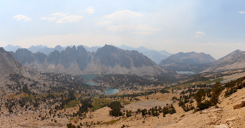
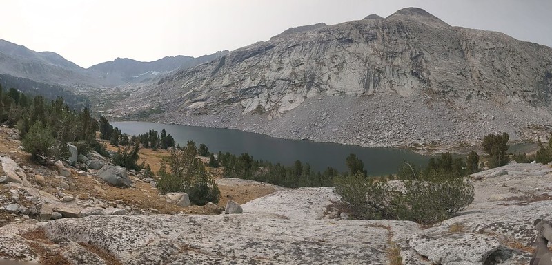
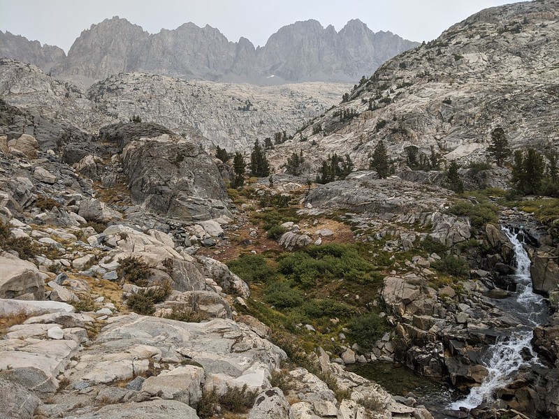
Panorama view west into the Kearsarge Basin from Kearsarge Pass, with the Kearsarge Lakes and Kearsarge Pinnacles

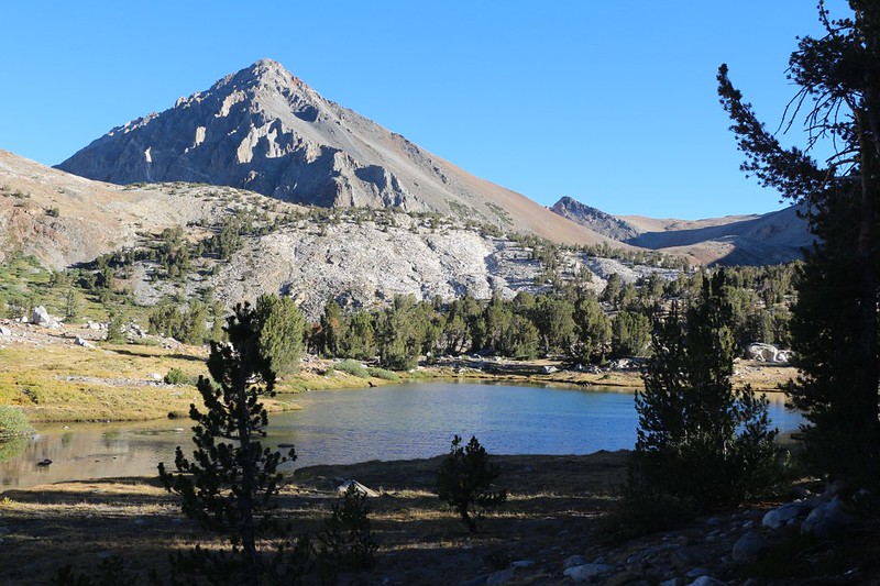
The sky was a bit more blue at the first of the Kearsarge Lakes
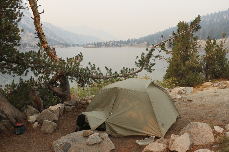
We set up camp across the way from the second lake, as it was pretty crowded that weekend. This day had been planned to be fairly easy, as we only hiked about six miles. Tomorrow we'd do about seven, and then after that we'd be cranking out ten-plus milers.
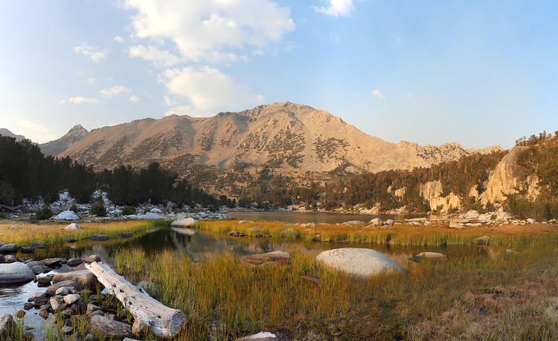
Mount Gould and Kearsarge Pass from the Kearsarge Lakes as evening approached
Day 2: Kearsarge Lakes to Rae Lakes via Glen Pass

We woke up early in the dark and smelled smoke in the air - the full moon was orange-colored from the smoke

The air was so hazy you could barely see the Kearsarge Pinnacles as we left camp at the Kearsarge Lakes
A fine rain of ash was falling, and you could see it the headlamp beams earlier that morning. We decided to put on our trusty cloth Covid Masks. On our way out, I commented to one of our neighbors that this was the first time since the pandemic began that I actually needed to use a mask! We all laughed, because it was true.

Looking down at hazy Bullfrog Lake from the "high trail" as we continued west toward the PCT

An orange sun rose into the smoky air above Kearsarge Pass, from the trail above Bullfrog Lake

Looking down at Charlotte Lake and Mount Bago from the Pacific Crest Trail
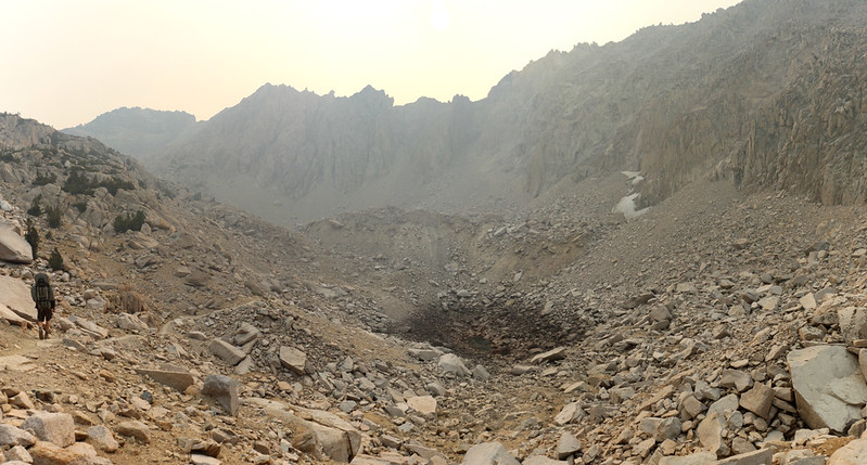
The lower lake below Glen Pass on the south side was almost dried up - the water had sunk down through the rocks

Smoky orange sun and orange reflections on the lake just south of Glen Pass

It was very smoky up on Glen Pass so the views were hazy but we posed for photos anyway

Somewhere out in that haze are the Rae Lakes - view north from Glen Pass
We spoke with some southbound JMT hikers and they all thought that the smoke was coming from the Creek Fire. That fire hadn't been very large when I looked at it a few days ago, but they said that it had doubled in size overnight and now was a major threat up north. I still swore that this smoke was from the SQF Fire down south, but without the satellite photos none of us knew for sure. But we all knew that it sucked, and the only good thing was that the fires were far, far away from us.
I apologized to my son for bringing him all the way out here to see such a lousy view, but he didn't care. It was the Sierra, and it was still gorgeous. And that was true enough.

Looking west as we descended from Glen Pass - the gray granite looked orange thanks to the smoke
Upper Rae Lake with Black Mountain left of center
Our campsite on Lower Rae Lake with orange sunlight filtering down through a tree onto the tent
The smoke got worse and worse over the next two hours. It appeared that we were directly in the thickest part of the smoke plume. The smell of smoke was very strong, and I'm sure that the air quality would have been rated as "unhealthy" if someone happened to have a particle counter handy.
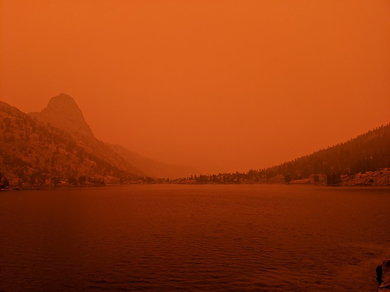
At 3pm the smoke reached an insane orange maximum in the air and the sun disappeared - Fin Dome to the north
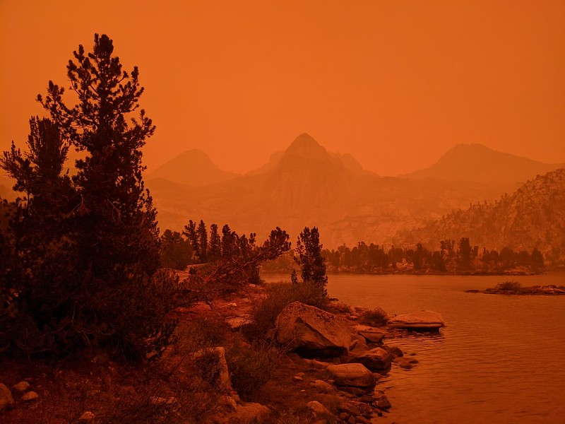
Ash was drifting down everywhere and the sky was deep orange, with Painted Lady visible over the Rae Lakes

By 5pm the main plume of smoke and ash had drifted away, and the sun was only slightly orange
Luckily for us, we had already filtered our lake water earlier. One of our neighbors only had tablets to treat the water, and he said that the upper six inches of the lake was cloudy with ash. Which he collected. So he treated the ash-laden water. And drank it anyway.
Day 3: Rae Lakes to Woods Creek
During this trek we would be hiking over five passes in seven days, and today was one of the two days with no passes. Instead, we followed the Rae Lakes water down the valley to Woods Creek, then climbed up along Woods Creek about halfway to the next pass. It was still a ten mile day, but without the extra views.

Fin Dome reflected in Lower Rae Lake just after dawn - most of yesterday's smoke had blown elsewhere

Handwritten sign at the Rae Lakes Ranger Station detailing closure of SEKI and Inyo NF to new entries on 7 Sept 2020
It turned out that they closed all the local National Forests on the Monday of Labor Day weekend. Today was Tuesday the 8th. I found the timing of the closure to be suspicious. It was as if they did it once they thought they could get away with it, after Labor Day, when the outcry would be minimal. For those here on the forum that had their permits cancelled, I feel your pain. I was simply thankful that we made it in here before the knee-jerk bureaucrats knee-jerked the forest closed. It's always safer for a bureaucrat to say no - it takes guts to say yes, and most of them don't have what it takes. They'd already closed the trails where there was actual danger, near the fires, so why did they close everything? It was like getting punished for somebody else's crime, or locking the barn door after the horse was stolen.
But enough ranting. I have a trip report to write!

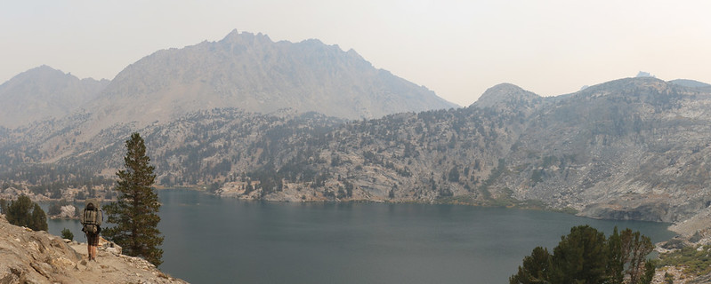
Panorama view west over Lower Rae Lake with Painted Lady (far left) and Fin Dome (far right)

Arrowhead Lake

Dollar Lake

The Suspension Bridge over Woods Creek on the JMT-PCT. What a great bridge!

The metal catwalk on the bridge deck was rocking and wobbling with every step
We ate lunch next to the creek and the bridge. We took a bunch more photos. We really liked that bridge. And then we remembered that we had a whole lot of uphill climbing ahead of us. So on we trudged into the afternoon.

Woods Creek flowing down smooth granite

The trail paralleled Woods Creek as we continued north - the air was turning smoky and orange again

As we hiked north up Woods Creek, we got a glimpse of clear blue sky - maybe we could leave the smoke behind!

We continued uphill along Woods Creek, and finally had clear blue skies and clean air!
Being under a blue sky really improved our morale. And it was nice to see crisp-edged mountains all around us. We just hoped it was gone for good. It also made me think that I was correct about the SQF Complex being the source, but I'm not sure I'll ever find out unless I review historical satellite records. Sounds like too much work for too little profit.

Sunset from our campsite near where the Sawmill Pass Trail intersects the PCT
Day 4: Woods Creek to Upper Basin via Pinchot Pass
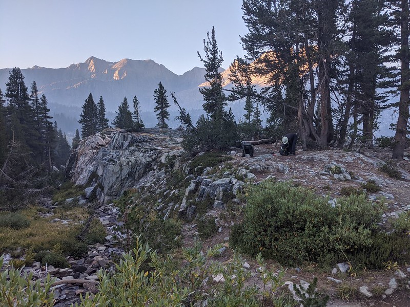
Getting ready to hike just after dawn with minimal smoke and haze
Mount Wynne (13179 feet elevation) above an unnamed lake

Panorama view of Crater Mountain, Pinchot Pass, and Mount Wynne

Crater Mountain and the trail we just climbed down below us
Panorama view south from the trail just south of Pinchot Pass, with the smoke still sneaking up below us in the Woods Creek Valley
The smoke was following us! We started hiking even faster.

Pinchot Pass, with Mount Ickes right of center
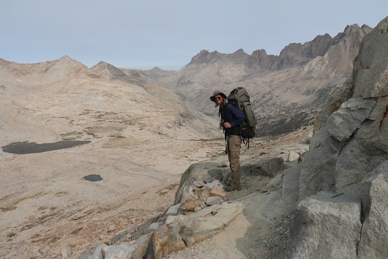
For once, we had the pass all to ourselves. We stopped and enjoyed the high-altitude solitude. We were still meeting occasional groups heading south on the JMT, bound for Whitney, but hardly anyone at all heading north. We kind of liked it this way. We hung out for a bit on the pass, taking tons of photos. We kissed the evil smoke good-bye, then headed on down the valley to the north.

Panorama view northwest from the trail just north of Pinchot Pass, with Lake Marjorie on the right

Lake Marjorie, with some hazy smoke rising up behind the mountains from the south. Still chasing us, we noticed.

Looking north over the small lake below Lake Marjorie
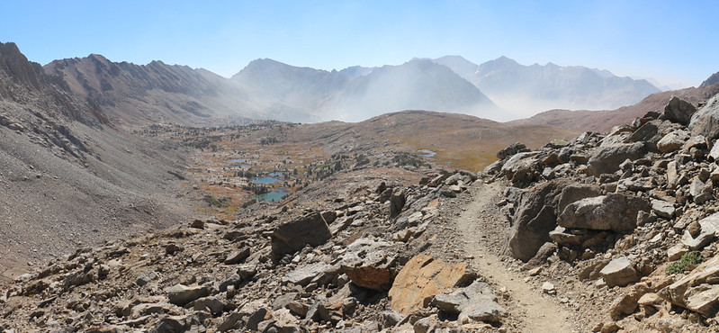
Down at the bottom of the valley, we crossed the South Fork Kings River and started heading upward again. Our plan was to get at least halfway to Mather Pass, and camp somewhere in Upper Basin.

The South Fork Kings River was very calm and had a shallow grade with grassy shores. We wanted to build a cabin along here, and go fishing every day.

View from our campsite in Upper Basin.
The smoky haze continued to dominate the sky to the south and west but we remained in clear air under blue skies. We vowed to hike a bit further and faster tomorrow, in the hopes of leaving it behind for good.
Day 5: Upper Basin to Palisade Creek via Mather Pass

Looking south toward Mount Ickes (center) before dawn from our camp in Upper Basin
It was cold out there that morning, so we got ready as fast as we could and started hiking to get warm. It wasn't just the smoke that motivated us this time.

There was ice on the ground and the air was cold above 11,000 feet elevation

High tarns in Upper Basin with Split Mountain left of center as we headed toward Mather Pass

Mather Pass came into view ahead of us

We finally made it to Mather Pass, with Twin Peaks to the east along the ridge

Panorama view southeast from Mather Pass, with Upper Basin and the headwaters of the South Fork Kings River

Panorama view north from Mather Pass, with the Palisade Lakes and the Palisade Crest (center)
Hiking north from Mather Pass into the Palisade Creek drainage.
We had to descend about 8 miles and 2600 feet from there. We were hoping to camp close to the lowest point, near the Middle Fork Kings River, in order to make tomorrow's big climb into Dusy Basin a little shorter.
Mather Pass is the low spot on the far left. This is where we ate lunch high above one of the Palisade Lakes

Lake 10613, the lowest of the Palisade Lakes, just before the valley really dropped off
Mount Williams, Norman Clyde Peak, and Middle Palisade above a waterfall, looking back up Palisade Creek

Waterfall on the headwall of the lower valley

Easy hiking alongside Palisade Creek, and we were finally below tree line

After a long day of hiking, we made camp next to Palisade Creek.
We had hiked over 13 miles that day, the longest day of the trip. We were also down below 9,000 feet elevation, and were hoping for a warmer night this time. We had slept with our gloves and hats on last night.
Day 6: Palisade Creek to Dusy Basin

We woke up before dawn and it was still cold, so we lit the stove inside the tent to warm things up while we got dressed
It looked like the cold air had flowed down the valley, which wasn't all that surprising. I should also mention that we lit that stove strictly for purposes of taking the photo, so that we could prove useful to the forum as Bad Examples. Plus, it didn't really work all that well for getting dressed. To avoid melting the sleeping bags, we had to turn the flame off first, and by the time we were actually dressing the heat was already gone. In other words, kids: Don't Try This At Home!

We arrived at the Middle Fork Trail - PCT/JMT junction and heard a lot of water roaring nearby, so we put down our packs to go check it out

Wide angle panorama shot of the Middle Fork Kings River where it cascaded over smooth granite
We realized that we should have hiked the extra mile last night, and camped down here, where the excellent waterfall was. Too late now!

The orange sun rose through the smokey haze to the east, and we hoped to continue heading north to avoid it
The orange color made me wonder if WE were the ones in the smoke, down here in the bottom of the river drainage. Smoke will do that at night. But we still didn't like it.

Looking north up Le Conte Canyon over Grouse Meadow with the languid Middle Fork Kings River
There were zero bugs there that morning, so late in the season. But we wondered what this place would be like in the Spring. Hmmmm... Clouds of ravenous mosquitoes in search of human blood...

The Citadel and the Middle Fork Kings River in Le Conte Canyon

Signs near the Le Conte Ranger Station at the Bishop Pass Trail and the PCT stating that all northbound hikers must exit here - good thing this was our plan!
We took a long break before starting the ascent to Dusy Basin. We had hiked almost five miles out of ten, so we were doing OK. We also had a total of 3200 feet to climb that day, but 2500 feet of it was still ahead of us. We looked at the topo map. There were a whole lot of switchbacks in our immediate future. This was the biggest climbing day of the whole trip, and we weren't even climbing over any passes! It didn't seem fair.

Wide-angle shot of the Dusy Branch cascading down into Le Conte Canyon, with Peak 11458 and The Citadel

The views only got better as we climbed up the trail toward Dusy Basin, with Langille Peak on the left

It's great to be alive and backpacking in the High Sierra! Life doesn't get much better than this! And that's a fact.

One last view of Le Conte Canyon as we climbed up and into lower Dusy Basin
You may not have noticed, but the smoke is to the south (left), and the blue sky is to the north. As usual. Running from smoke was really getting old at this point. We had gotten a weather report through my InReach and it looked like the weather might be changing later on that day. Hopefully with a good north wind to blow it all away.

The biggest climb was done, and it was time for an extended break, along a smooth-flowing stretch of the Dusy Branch

Columbine Peak and Knapsack Pass in lower Dusy Basin

Our tent and campsite in upper Dusy Basin with Agassiz, Winchell, Thunderbolt, North Palisade, and Isosceles
Let's be honest: This view is what made us climb 3200 feet that day. And just look at that beautiful blue sky! Oh, yes.
Day 7: Dusy Basin to South Lake via Bishop Pass
This was the final day of the trek, and, even though we love backpacking in the High Sierra, we really just wanted to head back to civilization for some juicy burgers. So we woke up at 3:30am and started hiking in the dark, headed uphill for Bishop Pass. It was icy cold up in camp at 11,000 feet, and there was a stiff breeze blowing out of the north. Just like we'd hoped, and we knew that we'd finally beaten the evil smoke. Hooray!
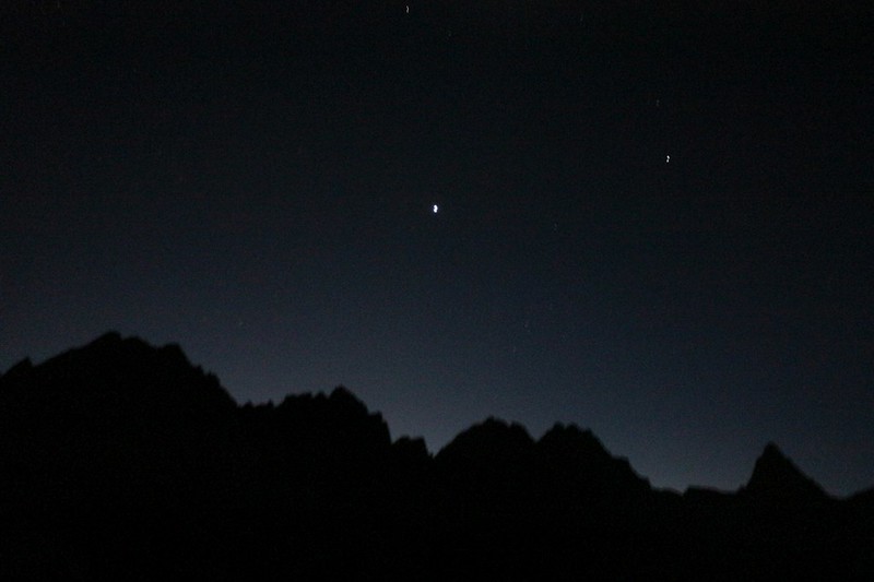
Crescent Moon and Venus over Agassiz, Winchell, Thunderbolt, North Palisade, and Isosceles from Dusy Basin

Dawn alpenglow over Dusy Basin from the trail as we neared the pass

Looking down at the Bishop Lakes and Bishop Creek from Bishop Pass in the morning light

Looking down at the Bishop Lakes from the trail just below Bishop Pass

Saddlerock Lake (11128 ft) with Mount Goode (13085 ft) and Hurd Peak (12237 ft)

Looking back, south over Long Lake, with Bishop Pass on the left, and Mount Goode on the right

Timer shot using my phone camera of the two of us at South Lake
We got to the trailhead parking lot and there was another group just finishing loading their gear into an SUV. It was the only car present. The driver offered me a ride down to the dirt parking lot, and I accepted immediately. We had known that we'd have to hike that extra three miles. But not any more. Life was good again. Yes, sometimes waking up early pays off, and this was one of those times.
My car was one of the few left in the lot below the Tyee Lakes trailhead after they closed the wilderness to hikers

Notice on my windshield from Inyo National Forest stating that the entire forest was closed due to the 2020 wildfires
I got in the car and drove back to the trailhead. While we were loading our packs, a National Forest Law Enforcement Officer arrived. He was suspicious, and thought that we were sneaking into the forest. But no, we assured him. We were done. We were leaving. Right now, officer.
We headed back to Bishop and ate the burgers we had been dreaming of. After that, it was time to head back home to San Diego. We decided that the trip had been plenty of fun, regardless of the smoke. If anything, that crazy smoke at Rae Lakes had been something worth talking about for years. Sometimes you need a bit of adversity to really get a good story going.
And we made plans to try for Whitney again next Summer. Maybe this time we'd try it from the south instead, just to change our luck. One of these years we're going to make it.
Map and GPS tracks on my CalTopo Page
Lots more photos and videos on my Flickr Album Page
.