Page 1 of 3
Kaweah Basin trip report
Posted: Mon Jul 02, 2007 12:33 pm
by copeg
Spent the last week+ traveling to, from, in, and around Kaweah Basin. I started and ended my trip at Rowell Meadow, going by way of Cloud Canyon and Colby Pass, starting my x-country part of the trip above the Kern-Kaweah river across from Kern Point (
map). No snow along the way, and very easy creek crossings (I think my feet got wet once the entire way). The x-country route turned out to be slightly rough but relatively easy to climb and navigate. Once I reached the ridge I traversed below the lowest lake on Picket Creek where its an easy climb up to the lake. From there I took the easy pass into Kaweah Basin and camped near the outlet of one of the lower lakes (
map), arriving early enough to explore the area around the lower lakes a bit. The following days I explored the basin and the lakes east of Red Spur, then found myself back along Picket Creek to explore that area, where I camped at the lowest lake along the creek. This lake was so amazing, with great fishing and great views up Picket Creek and across the Kern River valley toward the Sierra Crest. The next two days were spent on the trail hiking out. Many of the passes looked mostly clear of snow, but I talked to a person who had come over Pants Pass and said he had one heck of a time negotiating the snow. I bailed out of doing a loop because of this.
I shouldn't have been, but was astonished at how pristine this whole area was. It all had such a magical feeling to it. Very few signs of humans ever being in the area - only some old fire rings to let me know. Several rock slides shattered the silence of the basin, one large one off the south ridge of the basin left a cloud of dust blowing across the sky. My head is still in a different world now so its hard to write up everything I want to, I hope to try to add more details and more photos in the future, but here are a few that I've processed so far:
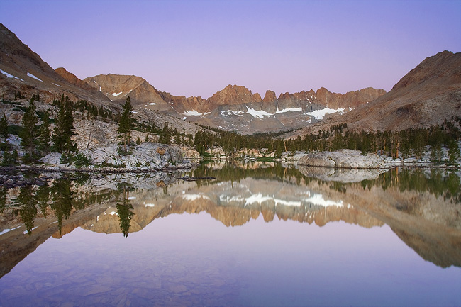
Early morning twilight in Kaweah Basin
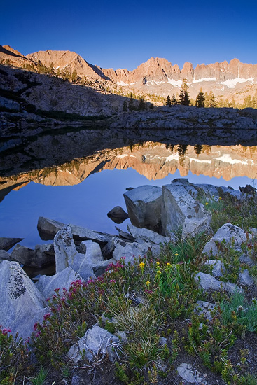
Sunrise alpenglow
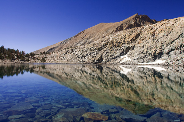
Lake along the Red Spur
Posted: Mon Jul 02, 2007 1:35 pm
by Skibum
Thanks for the report! I'll be in Cloud in a couple weeks when I get back from the east side. Can't wait! Any bugs?
I really like that middle shot. What type of camera do you use? Digital?
Posted: Mon Jul 02, 2007 4:23 pm
by maverick
Dont you get the feeling that "this was the way the Sierra used to
be like" when you enter KB.
Did you get to the upper lakes(11000ft)? Alot of the smaller ones were
dried up when I was there the last time.
Did you get to spend time at the swimming hole(last lake on
Picket Creek)?
The view towards the Whitney area from Red Spur Basin is
unmatchable.
If I could be there right after some thunderstorms that whole range
would change colors like a chameleon!
Sounds like a great trip, can hardly wait to revisit the area.
Posted: Mon Jul 02, 2007 5:02 pm
by maverick
By the way nice pic's! I know you have some more coming, right?
Posted: Mon Jul 02, 2007 6:54 pm
by copeg
Thanks skibum and maverick.
Skibum, these were digital - canon rebel xt. Took some film shots, but not many and haven't developed them yet. Mosquitos weren't too bad along the way - but pretty thick in the evening between 9k and 11k. Minor in many of the meadows along the way (Rowell, Comanche, Sugarloaf, etc..) (The horse flies between Rowell and Comanche were horrid on my way out - didn't bite but drove me up the wall ]
](./images/smilies/eusa_wall.gif "Brick wall")
). I encountered few mosquitos at Big Wet Meadow on the way in, and a few on the way out. Mosquitos were horrid where the trail turned up to climb toward Colby Lake.
Maverick, that same thought went through my head so many times and I think I wrote that same line in my journal over and over, and recited it to everyone I've told about this trip since I've been back. Simply amazing. Got to the upper lakes - none were dry and none were frozen. Those two large upper lakes, I just sat for hours in amazement - the color of the lakes beneath those spires of the Kaweahs, the birds dancing in the air, the wind breezing by... I couldn't believe the view east from the lakes near Red Spur - could see south of Langley all the way to the peaks near Forester and Upper Kern, wow

More pics soon...
Posted: Mon Jul 02, 2007 7:13 pm
by hikerduane
Thank you for the early photos and trip description. I'm slowly exploring more of the southen Sierra. Rae Lakes loop this year, then tie some more country to other territory later. So much country to see.
Posted: Tue Jul 03, 2007 12:18 am
by rightstar76
.
Posted: Tue Jul 03, 2007 10:44 am
by copeg
Thanks duane and rightstar.
Here's a link to some more photos, I'd like to put more up with a better detailed trip report - but we'll see when I can get around to that
 Kaweah Basin
btw maverick, yes I did stay a night at that last lake on picket creek - when I first saw that lake I literally lost my breath - it is so beautiful
Posted: Tue Jul 03, 2007 6:32 pm
by doug395
Trailblazer - you always pick great places to explore, the images from this trip are just amazing and do a pretty good job explaining that magical felling you were talking about.
Posted: Tue Jul 03, 2007 9:31 pm
by quentinc
Those are indeed fantastic pictures.
I've done hundreds of trips in the Eastern Sierras but have never been in this area at all, and now I really want to! How many miles is the hike in from the trailhead to your turnoff point near Kern Peak?
I had also been contemplating a trip around the western side of the Kaweahs, by way of Glacier and Black Rock passes to Nine Lake Basin. Any thoughts on how that compares to this route (for those of you who have done both, and I'm sure you're out there!). I take it that once the snow melts, Pants Pass is a decent route to do a round trip starting and ending at Sunset Meadow Road?