Page 2 of 2
Re: SEKI Loop Advice
Posted: Tue Feb 26, 2019 8:33 am
by sekihiker
Re: SEKI Loop Advice
Posted: Sun Mar 10, 2019 7:58 am
by agfhst
Quick follow-up question about the Alta Meadow/Moose Lake/Pterodactyl Pass route that some have suggested: is the terrain on that route basically class 1 or easy class 2? From Google Earth, it looks like it's mostly slab terrain like the Tablelands.
I'm planning a similar trip through that area in late August (Wolverton/Pterodactyl/Elizabeth/Roaring River/Colby/Kern-Kaweah/Picket Creek/Kaweah/Shepherd Pass). One of my friends hiked somewhere south of Moose Lake a few years ago. He can't remember exactly where, but he does remember "a nightmare of talus" which, along with some weather, led his group to hike down Buck Creek to the HST.
He doesn't want to repeat that experience, so I'm hoping to provide him some assurance that the Alta/Moose/Pterodactyl route is not so bad, if that's the case. Thanks-
Re: SEKI Loop Advice
Posted: Sun Mar 10, 2019 1:35 pm
by maiathebee
agfhst wrote: ↑Sun Mar 10, 2019 7:58 am
Quick follow-up question about the Alta Meadow/Moose Lake/Pterodactyl Pass route that some have suggested: is the terrain on that route basically class 1 or easy class 2? From Google Earth, it looks like it's mostly slab terrain like the Tablelands.
I'm planning a similar trip through that area in late August (Wolverton/Pterodactyl/Elizabeth/Roaring River/Colby/Kern-Kaweah/Picket Creek/Kaweah/Shepherd Pass). One of my friends hiked somewhere south of Moose Lake a few years ago. He can't remember exactly where, but he does remember "a nightmare of talus" which, along with some weather, led his group to hike down Buck Creek to the HST.
He doesn't want to repeat that experience, so I'm hoping to provide him some assurance that the Alta/Moose/Pterodactyl route is not so bad, if that's the case. Thanks-
From Alta to Moose there is only a small amount of talus if you choose the route properly. If you go too high or too low, there's large talus that can be steep. Through the middle there's an old trail to follow. When I was out there in 2014, we found the right route on the way to Moose but missed it on the way out somehow. The difference in difficulty was significant. Trip report
here. I can't imagine thinking that following Buck Creek down to the HST would be the easiest way out of there. Maybe if there was weather and you really needed to descent for some shelter (everything up there is very exposed), but you'd first have to get down to these tarns, then down to the creek, which has a lot of cliffy areas.
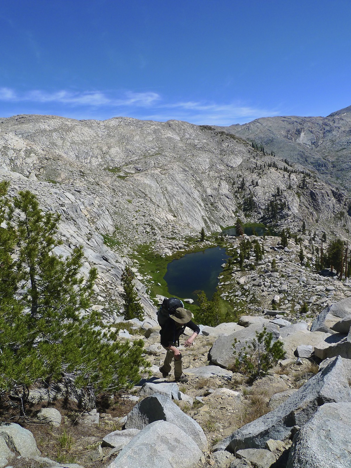
Climbing back up to the ridge to head back to Alta Meadow by
Maia Averett, on Flickr
Haven't gone from Moose over Pterodactyl but looked at it from Pterodactyl and it looked annoying as hell if you accidentally get too low, so watch out for that.
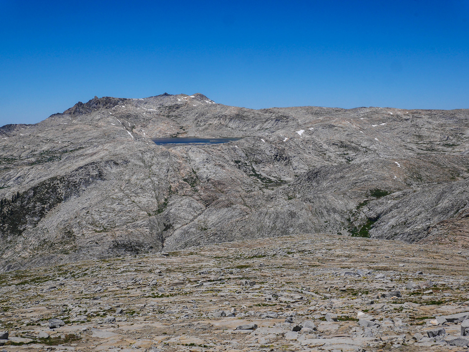
Moose Lake from Ptetrodactyl Pass by
Maia Averett, on Flickr
Re: SEKI Loop Advice
Posted: Sun Mar 10, 2019 2:43 pm
by agfhst
Thanks, Maia - very helpful information both in this post and your blog post, and great pictures. Good to know that there's something of a trail from Alta Meadow to the lake - hopefully we'll find it.
Once we got to Moose Lake, the basic idea would be to cross the outlet stream and head northnorthwest, staying above Buck Canyon, then circling around the head of the canyon to Pterodactyl Pass, Lonely Lake and so on. Your second photo gives me a pretty good sense of what that route would be like -- some ups and downs, but doesn't look like the hiking is that difficult.
-Andy
Re: SEKI Loop Advice
Posted: Sun Mar 10, 2019 9:02 pm
by wildhiker
I thought the worst part of the hike from Alta Meadow past Moose Lake to Pterodactyl Pass was getting stuck in brush east of Alta Meadow. In 2011 we found some fragments of old trail in the forest contouring east from the top of Alta Meadow and then once on the main ridge above Buck Creek, there was a well-defined trail continuing to Moose Lake. Beyond Moose Lake it was mostly slab and meadow walking. You have to stay high contouring around the head of Buck Creek to avoid little cliffs. I don't remember any significant talus. From Pterodactyl Pass, we dropped down into the little basin below, at least 500 feet elevation loss and then climbed back up to Lonely Lake. It looked easier to us than trying to contour around at the same elevation. We found a decent campsite among scattered whitebark pines on the low ridge just west of Lonely Lake. Both times I have camped here, a buck wandered into camp area to within 20 feet of where I was sitting, seemingly curious about me, but not afraid. From Lonely Lake, follow up that ridge on the west side to Horn Col. There are some steep slabs that you have to traverse just before the col, but if you hit the route right, you can cross on a lower grade. Maybe a tiny bit of class 2 just getting down from the immediate col, and then easy class 1 on slabs and meadows over to the Elizabeth Pass trail.
-Phil
Re: SEKI Loop Advice
Posted: Mon Mar 11, 2019 5:24 pm
by agfhst
Thanks for the detailed info, Phil, that's very useful. Our plan is to camp at Moose Lake and then Ranger Meadow, but maybe if the timing works and we're feeling good we'll keep going past Moose Lake to that site near Lonely Lake. Interesting that the buck was there repeatedly. Doesn't look like there's a lot for a deer to eat up in that area. But maybe he gets tired of hanging out in Buck Canyon all the time.
-Andy
Re: SEKI Loop Advice
Posted: Mon Mar 11, 2019 7:36 pm
by Wandering Daisy
In 2014 I camped on a bench about 200 feet below Lonely Lake and this deer approached, with no fear of humans at all! I suspect they come up from the Tamarack Lake area.
00_small15_IMG_8435.jpg
On an early July trip in 2006, Lonely Lake had no camping because of snow, so I filled water bottles and camped up on the ridge above Big Bird Lake. There were nice flat sandy sites in scrub timber and the view was fantastic.
09_TBL_BigBirdLk.JPG
Re: SEKI Loop Advice
Posted: Tue Mar 12, 2019 7:40 pm
by agfhst
Nice photos, WanderingDaisy -- looking forward to that view over the ridge. Looks like a nice moment there with the deer -- hopefully we'll have some deer visitors too.