Here are some photos of Lake 10559 north of Table Meadows taken on August 23, 2011 - a summer after a heavy snow pack.
First one is the view from the Kings-Kaweah Divide looking west across Lake 10559:
Second is the view from the west side of Lake 10559 looking east, with the ugly weather station placed prominently where everyone can see it!
-Phil
tablelands questions
-
wildhiker

- Topix Fanatic
- Posts: 1112
- Joined: Tue Jul 26, 2011 4:44 pm
- Experience: Level 4 Explorer
- Location: Palo Alto, CA
- Contact:
Re: tablelands questions
You do not have the required permissions to view the files attached to this post.
-
Harlen

- Topix Addict
- Posts: 2097
- Joined: Sat Mar 11, 2017 9:13 am
- Experience: Level 4 Explorer
- Location: Santa Cruz Mountains
Re: tablelands questions
I too was inspired by Maia's trip report. The image that really got to me was the view east from Horn Col (aka "Fin Col?). I felt that I just had to walk along that great granite arc! I came at it from the east, and the granite had turned to snow, but I still found that area really beautiful. So if you find yourseIf within shooting distance, I would highly recommend a day hike up to that magic Horn Col. Good luck, Ian.
Maia wrote
I couldn't manage to import those 2 photos of yours Maia? Can you slip them in? They will inspire someone else too. Ian.
[They are the two just below your sentence above.]
Maia wrote
Instead, I headed straight up to the ridgeline north of Horn Col itself. It was views I was after, anyhow, and holy heck it was views I got.
Image
Image
I couldn't manage to import those 2 photos of yours Maia? Can you slip them in? They will inspire someone else too. Ian.
[They are the two just below your sentence above.]
Last edited by Harlen on Sun Jan 06, 2019 3:38 pm, edited 1 time in total.
Properly trained, a man can be dog’s best friend.
-
oleander

- Topix Expert
- Posts: 480
- Joined: Wed Aug 18, 2010 10:15 am
- Experience: N/A
Re: tablelands questions
I've camped at that little lake. It was pretty, but it didn't rock my world, and wasn't all too memorable. If I were to camp in that area again, I'd instead choose to camp in the gorgeous slabby areas approx 200 vertical feet downstream from that lake, on the north side of the main stream.frozenintime wrote: ↑Fri Jan 04, 2019 2:11 pm thanks for the info!
i wanted to double check that we're talking about the same lake. since you use the phrase "above table meadows" it makes me think of lake 10,559. i was thinking of the lake marked on this map (https://mapper.acme.com/?ll=36.61631,-1 ... %2Cunnamed).
anyway, thanks for the reply:)
But Lake 11,200 was even better. I disagree that you can't see much of the GWD from there. The view is really unique somehow. Both intimate and all-encompassing at the same time.
-
frozenintime
- Topix Regular
- Posts: 299
- Joined: Tue Aug 18, 2015 8:06 pm
- Experience: N/A
Re: tablelands questions
ian, yes! horn col is such a striking shape. i absolutely plan to dayhike up to it from lonely. (i'm not particularly interested in any of the routes that pass through it this year, for some reason.)
oleander, thank you! i've read all your tablelands reports as well.
oleander, thank you! i've read all your tablelands reports as well.
-
maiathebee

- Topix Expert
- Posts: 470
- Joined: Tue Jun 18, 2013 11:59 am
- Experience: Level 4 Explorer
- Location: Alpine Meadows, CA
- Contact:
Re: tablelands questions
Ha, I'm reading this thread to plan for another Tablelands trip next week (this time more NW / Sillman) and just noticed some mentions. Glad y'all were inspired!
Per request of @Harlen , some photos from the ridgeline north of Horn Col.
 Upper Deadman Canyon from near Horn Col by Maia Averett, on Flickr
 Ridgeline north of Horn Col by Maia Averett, on Flickr
 Deadman Canyon from ridgeline north of Horn Col by Maia Averett, on Flickr
I'm using a 7 year old Panasonic Lumix GX-7. It's about to die. I hope it survives one more summer!frozenintime wrote: ↑Thu Jan 03, 2019 2:37 pm maia, it's an amazing report! so well written and photographed. are you using something other than an iphone camera? i'd guess so, but i've been wrong before.
Per request of @Harlen , some photos from the ridgeline north of Horn Col.
Upper Deadman Canyon from near Horn Col by Maia Averett, on FlickrRidgeline north of Horn Col by Maia Averett, on FlickrDeadman Canyon from ridgeline north of Horn Col by Maia Averett, on Flickroh hey! you're reading my signature.
that's nice. want to check out my blog?
here it is: plutoniclove.com
ig: @plutonic_love
that's nice. want to check out my blog?
here it is: plutoniclove.com
ig: @plutonic_love
-
sekihiker

- Founding Member
- Posts: 958
- Joined: Sun Dec 18, 2005 2:47 pm
- Experience: Level 4 Explorer
- Location: Fresno
- Contact:
Re: tablelands questions
Here is a photo of the lake.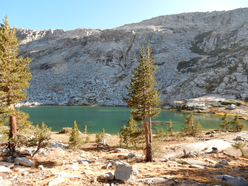
Not only are there a lot of places to camp around the lake, I remember being serenaded by lots of pikas.
It's easy hiking from the above pictured lake to the large lake to the north [Lk 10,559].
That gets you high on the Tableland. Remember - stay high if you want to go to Pterodactyl Pass. Otherwise there is a lot of up and down.
Who is online
Users browsing this forum: Bing [Bot] and 363 guests