If you've been searching for the best source of information and stimulating discussion related to Spring/Summer/Fall backpacking, hiking and camping in the Sierra Nevada...look no further!
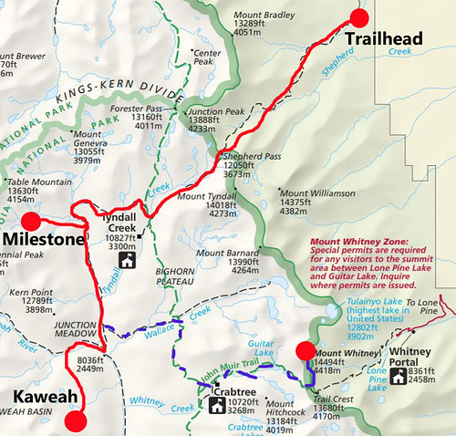
Level 3 backapacker here who is heading for Milestone and Kaweah Basin via Shepherds in a few weeks. Depending on time, I might do a side trip to Whitney too.
A couple of questions about the Shepherd's Pass trail:
1) Is Mahogany Flat the first camping area on the trek in, or are there other places suitable for camping along the way?
2) What is the water situation like along the trail? (I am trying to determine how much to carry.)
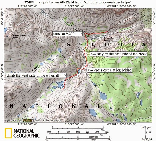
On Kaweah Basin, I've looked at several descriptions on the route in near Picket Guard. One of the easiest descriptions, I saw on this forum and I grabbed the map. For anyone that's gone this route, is there anything important I should be aware of or any tips?
I've found it easier to continue on the trail towards Colby pass and then turn back and ascend to PG creek. Perhaps less direct, but less talus. It's an easy scenic hop from PG creek (which is well worth your time).
Captain Slappy wrote:
1) Is Mahogany Flat the first camping area on the trek in, or are there other places suitable for camping along the way?
2) What is the water situation like along the trail? (I am trying to determine how much to carry.)
(1) There are some spots at the top of the 1st hill as you enter the Shepherd's creek drainage (you begin in the Symmes Creek drainage).
(2) Depends :-) on what time you leave. Along Symmes it can be HOT, suggest leaving early as possible in day. You have good water early (Symmes Creek) then (this time of year) when you get to Mahogany flat (hike/climb down to creek) and then Anvil Camp. Sometimes there is a creek running down the hill/across the trail before reaching Mahogany flat. Hard to say if its still flowing now.
I usually fill up right before the 1st hill for sure, and carry at least 1.2L (2 bottles), but I'm moving fairly quickly.
I was just there a few days ago. When starting from the Shepherd Pass Trailhead (I started at 3 a.m.), there are four easy stream crossings in the first mile. Then you have to ascend dry switchbacks to get to 9100 feet. There is a dry camp site on that first ridge. You descend to around 8600 before you start back up again, and the first water was around 8700 feet. Not too far higher you get to Mahogany Flat. Then eventually you get up the hillside to Anvil Camp, which had a good stream. The Pothole looked a bit buggy. Above that, you could go to the bottom of the snowfield that runs down from the pass. At the bottom is where the deer herd carcasses are from last winter's tragedy. There is a good snow-fed lake just west of the pass and its outlet flows to the west.
Why not go over Milestone Pass and into Milestone Bowl and Gallats Meadow (one of the prettiest meadows in the Sierra), much more scenic then heading down the trail to dusty and dry Junction Meadow.
Professional Sierra Landscape Photographer
I don't give out specific route information, my belief is that it takes away from the whole adventure spirit of a trip, if you need every inch planned out, you'll have to get that from someone else.
Have a safer backcountry experience by using the HST ReConn Form 2.0, named after Larry Conn, a HST member:http://reconn.org
Thanks, this is exactly the kind of advice I was looking for.
I am going to get a late start up Shepherd's and I appreciate the challenges that come with that, so it's helpful to have info on water and camping spots. I'm really hoping to be able to make it to the hiker's trailhead because that will at least shave a bit of the elevation and mileage off.
maverick -- awesome route suggestion. I looked at info on Milestone Pass today (which I had been considering on my Circle of Solitude hike) and it looks very doable.
thegib -- i think i've seen some reports where hikers took the route you're suggesting. I'll have to look more closely at that if it's easier.
Instead of going down to Rockslide Lake to ascend into KB, which a class 2 route with a little bush, which can be avoided, rather from Gallets Meadow, just ascend in an angle towards PG Lake, before you get to close to Kern Point, there are some previous TR's with specifics on this, won't get into any specifics, but PG Lake is one of the finest swimming holes in all of the Sierra.
Professional Sierra Landscape Photographer
I don't give out specific route information, my belief is that it takes away from the whole adventure spirit of a trip, if you need every inch planned out, you'll have to get that from someone else.
Have a safer backcountry experience by using the HST ReConn Form 2.0, named after Larry Conn, a HST member:http://reconn.org
Great trip you're doing Captain! I second Mav's Milestone Pass suggestion, and while you're at it, why not drop your pack on that pass and pop up onto that classic sharp pinnacle? Not only is it straightforward class 3 along the west ridge, but listen to what Roper says about the summit:
"The view of the Kaweahs from the top is one of the greatest Sierra sights."
The summit is actually a nice flat place to hang out awhile. Hope to enjoy your trip report soon.
Last edited by Harlen on Thu Aug 16, 2018 2:21 pm, edited 1 time in total.
I think I've gotten some good info on the route into Kaweah Basin via PG Lake from reading the meetup thread from a few years ago.
Getting to the summit of Milestone would be terrific. I've been reading route info, but it's tough to envision everything that's being discussed. I'll have all info saved to my phone so hoping it makes more sense when I'm on the ground.
I've also been keeping an eye on the smoke situation and keeping my fingers crossed. My backup hike was going to be the Northern Yosemite 50 miler through Hoover Wilderness starting at Twin Lakes, but that's looking smokier at this point. Backup to the backup will be something in the North Cascades.