Sawmill -> Pinchot -> Taboose 7/2017
-
oleander

- Topix Expert
- Posts: 480
- Joined: Wed Aug 18, 2010 10:15 am
- Experience: N/A
Re: Sawmill -> Pinchot -> Taboose 7/2017
I have a lot more to add about this wonderful trip, but wanted to start by saying that at Taboose Pass, we made a toast to Larry Conn 
-
maverick

- Forums Moderator

- Posts: 11837
- Joined: Thu Apr 06, 2006 5:54 pm
- Experience: Level 4 Explorer
Re: Sawmill -> Pinchot -> Taboose 7/2017
I have a lot more to add about this wonderful trip, but wanted to start by saying that at Taboose Pass, we made a toast to Larry Conn
Great to that hear, that some folks had Larry on their minds, while going over Taboose.
Professional Sierra Landscape Photographer
I don't give out specific route information, my belief is that it takes away from the whole adventure spirit of a trip, if you need every inch planned out, you'll have to get that from someone else.
Have a safer backcountry experience by using the HST ReConn Form 2.0, named after Larry Conn, a HST member: http://reconn.org
-
Shawn
- Topix Fanatic
- Posts: 1061
- Joined: Sat Nov 12, 2005 9:56 pm
- Experience: Level 4 Explorer
Re: Sawmill -> Pinchot -> Taboose 7/2017
Hobbes = Your TR was bitchin and I enjoyed the stats.
Oh, and the outstanding photos and descriptions of your experience too. Thanks for posting it up.
Maybe one year when I get out of gridlock I would actually have the time to make the annual get together.
Oh, and the outstanding photos and descriptions of your experience too. Thanks for posting it up.
Maybe one year when I get out of gridlock I would actually have the time to make the annual get together.
-
Jimr

- Forums Moderator
- Posts: 2178
- Joined: Fri Jul 31, 2009 2:14 pm
- Experience: Level 4 Explorer
- Location: Torrance
Re: Sawmill -> Pinchot -> Taboose 7/2017
Hobbes, you asked about my impression of Sawmill and Woods Lake basin. You summed it up exactly.
BTW, I think the spot you took the shot of Sawmill Meadow was our exact camp location. Was there a fire ring near a large burned log?I think I could definitely get into carrying a full load of tent, camp chair, etc up Sawmill to base camp & fish @ Woods lake for a few days at some future date. It really is that special
If you don't know where you're going, then any path will get you there.
-
Ashery
- Topix Acquainted
- Posts: 89
- Joined: Wed Jul 08, 2015 7:17 pm
- Experience: N/A
Re: Sawmill -> Pinchot -> Taboose 7/2017
I didn't see SAR people up close, but three choppers came down throughout the day this past Monday and landed in a small clearing just on the W side of the South Fork as it bent up towards Upper Basin. I saw the first two clearly as I was gradually making my way around to Cardinal Lake while trying to keep high and saw people get out, but the third came during the storm and by then I no longer had a vantage point on the clearing.Wandering Daisy wrote:I read that the lost PCT hiker's body was found in this area. Evidently drown. Did you see S&R people?
All that seems to fit in with what was posted on the SAR board about the recovery operation that day.
Last edited by Ashery on Tue Aug 01, 2017 4:06 pm, edited 1 time in total.
-
Hobbes
- Topix Fanatic
- Posts: 1120
- Joined: Wed Apr 27, 2011 8:09 am
- Experience: N/A
- Location: The OC
Re: Sawmill -> Pinchot -> Taboose 7/2017
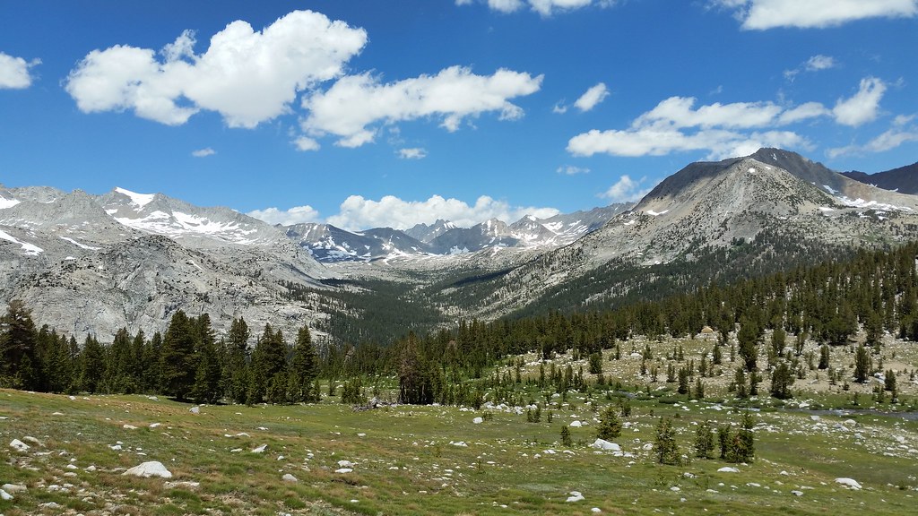
Mav, I explained the story about Larry to both Flamingo & Ashery while hanging at the top of Taboose. Since this was also a kind of memorial trip for Randy - even though we didn't make it through Window/White fork - I had a moment of reflection while sitting in this meadow before contouring around to Bench lake. Can you see the/his ranger "cabin" center mid-right?
I know I've said this before, but it appears the (entire) drive for going x-c is to avoid crowds and engage in perhaps more challenging terrain. But, are the zones off the JMT really that much more scenic? After all, the highest peaks, the most extensive meadows and the greatest prominence is right along the crest. So, if the objective is to avoid both crowds & mindless trail zombiefication, why not go early season?
You will not see many - if any - people, and the snow coverage & crossings most definitely forces one to engage in both reconnoitering and technical skill deployment.
-
Hobbes
- Topix Fanatic
- Posts: 1120
- Joined: Wed Apr 27, 2011 8:09 am
- Experience: N/A
- Location: The OC
Re: Sawmill -> Pinchot -> Taboose 7/2017
You mean the packer fireplace & chimney? Man, those guys know how to live; forget this 'roughing it' nonsense. Full comfort all the way letting mules carry your essential supplies. You know, things like a cooking stove, steaks, sleeping cot, etc.Jimr wrote:Was there a fire ring near a large burned log?
-
Jimr
- Forums Moderator
- Posts: 2178
- Joined: Fri Jul 31, 2009 2:14 pm
- Experience: Level 4 Explorer
- Location: Torrance
Re: Sawmill -> Pinchot -> Taboose 7/2017
No chimney and fireplace, but I've seen those. Ours was right off trail. I mean 10ft off trail. It had a huge bonfire ring with a smaller ring on an inner edge. It looked like the large bonfire ring was filled in with only the perimeter showing and a smaller ring was built within. Your shot was our camp view, so you were close. I kept looking for deer to show up in the meadow.
If you don't know where you're going, then any path will get you there.
-
cgundersen
- Topix Fanatic
- Posts: 1338
- Joined: Sun Jul 16, 2006 1:07 pm
- Experience: N/A
Re: Sawmill -> Pinchot -> Taboose 7/2017
Hobbes/Jim,
It's a long story (Joy's & my "failure-to-attend", and general lack of posting), with nothing as involved as raising kids, so we can bore you with the details some other time (but, it certainly has nothing to do with malodorous companions). Nevertheless, we have been managing to get out pretty regularly either before the snow melts or after Labor Day, which tend to be our favorite times. And, I have a pal from the East coast, who just confirmed his arrival on 16 August, so I'm winnowing through options for where to go with him. Daisy's comments about low bug counts up Pine Creek sure has me thinking! Oh, and the story about serving as the photographer-du-jour is reminiscent of an experience Joy had a couple years ago doing honors for a lone Japanese guy who had gleefully reached the ridge of Glen Pass and was thoroughly stoked looking down toward Rae Lakes. His English was as scant as our Japanese, but the stone-age communication was superb and we're pretty sure that he got at least one lasting memento. It was fun sharing his delight! Cheers, Cameron
It's a long story (Joy's & my "failure-to-attend", and general lack of posting), with nothing as involved as raising kids, so we can bore you with the details some other time (but, it certainly has nothing to do with malodorous companions). Nevertheless, we have been managing to get out pretty regularly either before the snow melts or after Labor Day, which tend to be our favorite times. And, I have a pal from the East coast, who just confirmed his arrival on 16 August, so I'm winnowing through options for where to go with him. Daisy's comments about low bug counts up Pine Creek sure has me thinking! Oh, and the story about serving as the photographer-du-jour is reminiscent of an experience Joy had a couple years ago doing honors for a lone Japanese guy who had gleefully reached the ridge of Glen Pass and was thoroughly stoked looking down toward Rae Lakes. His English was as scant as our Japanese, but the stone-age communication was superb and we're pretty sure that he got at least one lasting memento. It was fun sharing his delight! Cheers, Cameron
-
SSSdave
- Topix Addict
- Posts: 3524
- Joined: Thu Nov 17, 2005 11:18 pm
- Experience: N/A
- Location: Silicon Valley
- Contact:
Re: Sawmill -> Pinchot -> Taboose 7/2017
Hobbes wrote:...I know I've said this before, but it appears the (entire) drive for going x-c is to avoid crowds and engage in perhaps more challenging terrain. But, are the zones off the JMT really that much more scenic? After all, the highest peaks, the most extensive meadows and the greatest prominence is right along the crest. So, if the objective is to avoid both crowds & mindless trail zombiefication, why not go early season?...
Well that is sometimes true for some people but of course there are many more reasons backpackers go cross country depending on their interests. Am sure you were speaking in a narrower sense than what you wrote.
By going beyond trails one hugely expands the potential backcountry area one can explore and play in. Trails tend to be laid out for efficient travel between historical backcountry locations and not with regard for scenery, fishing, or access to special peaks and places. Historically most of trails were also routed to be horse friendly avoiding unpleasant to horse rocky, topographically awkward, and steep areas while affording places to graze down in forested areas camp fires could be built. Even where trails route, for those on foot with good creature monkey skills, there are often ways to cheat trails with short cuts. On my trips, I scrutinize trails for places I might do so in the interest of reducing effort. For instance east of Sawtooth Pass on the Lost Canyon trail on our way to Big Five Lakes, we always vector off the trail at 9960 here:
http://mapper.acme.com/?ll=36.46741,-118.51239&z=15&t=T
then traverse up the canyon slopes towards the no name pond at 10070 instead of taking the trail that otherwise drops 360 feet before climbing the ridge.
The PCT and JMT do at times route through some of our grandest areas but they also miss a lot. Many times they miss incredible scenery that is just short distances from trails. As a photographer, I just shake my head at times when discovering incredible ignored locations that are close to heavily used trails. There are vast areas just beyond trails and off use routes that rarely see boots, especially if such requires climbing up above trails more than a little vertical. For fishermen like GB, the interest is often to go where few men have gone before, where lakes, especially no name lakes, have been less impacted leaving more abundant and larger trout.
Experienced backcountry peak baggers tend to have strong off trail skills due to the nature of their game and targets. Accordingly their interests are about efficiently staging camp spots near their targets with little regard for whether getting there is on a trail or not as long as it is easiest and or quickest.
For a serious photographer, the crowd or challenge issues are again not of much concern but rather being at scenic locations at time of year and time of day when subjects are most aesthetic. Sometimes that happens to be right where a trail is, as at the Thousand Island Lake outlet where the JMT and PCT cross. Other times it may require climbing up cross country to better views like to Orchid Lake with Seven Gables and Feather Peak. Generally for this photographer, I prefer mid July thru mid August, for timberline areas when landscapes are most green and flowery and some snow still adorns peaks and shadows with their melt streams still common across landscapes. Late season when grasses and vegetation is often drab dry and brown provides less color.
Early season when there is still considerable snow on landscapes aesthetically tends to be sterile and lack a mix of color. The time of day with workable light is greatly reduced to early and late because as soon as the sun rises up, snow becomes much too bright for the dynamic range of digital image sensors. Though that is not to say there are some situations where a lot of snow on a landscapes provides unique opportunities as the image below ( 9 frame 20,000 pixel wide stitch blend) I just processed yesterday from the Desolation Wilderness trip I returned from last Thursday. Snow with a mix of light granite provides a more interesting mix of early warm light and element geometries than after it melts when it is all just the same orange.

David
Who is online
Users browsing this forum: astranko, Google Adsense [Bot], jefffish and 421 guests